Linden stump
| Linden stump | ||
|---|---|---|
|
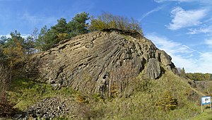
Basalt columns in mile construction |
||
| height | 527 m | |
| location | Bad Kissingen district , Bavaria | |
| Mountains | Brückenauer Kuppenrhön , Rhön | |
| Coordinates | 50 ° 16 '42 " N , 9 ° 51' 38" E | |
|
|
||
| Type | Chimney filling | |
| rock | basalt | |
The Lindenstump is a mountain in the southern Rhön , about one kilometer north of the Bavarian community Schondra and 500 meters southwest of the federal highway 7 in the Bad Kissingen district . The lime stump is 500 meters above sea level , but only towers over the area by about 40 meters. Its summit has a pit about 350 × 200 meters wide and 25 meters deep, which goes back to a former basalt quarry. The entire area with around 9.8 hectares was designated as a protected landscape component on February 8, 1994 .
description
The linden stump is just one of the numerous basalt domes of the Rhön. The Rhön volcanism lasted from the late Oligocene (approx. 25 mya ) to the early Pliocene (approx. 5 mya). The basalt in the former quarry today open-minded is, comes from magma that did not reach up to the surface, but in the vent cooled the Lindenstumpf volcano. This chimney was cut by the quarry. Therefore, today clearly pronounced basalt columns can be observed there, which were created by the relatively slow cooling of the basaltic lava. They are arranged radially and rise more and more flat towards the middle, similar to a coal pile - this is why one speaks here of pile construction . Since the basalt columns are always oriented perpendicular to the temperature gradient, this position indicates that the chimney passed into a ceiling discharge that was eroded naturally long before the quarry was set up .
The stump of lime is surrounded by hedges running parallel to the slope on stone walls and meadows in between. The relatively flat former quarry floor is almost completely enclosed by the approximately 25 meter high, artificial basalt edge . Only on the south side is an opening a few meters wide through which the freshly crushed basalt was transported away. There are small cones of rubble and hollows on the former quarry floor. There, spread dry grass and moss - and lichen-covered surfaces with emerging trees. There are amphibian spawning grounds on waterlogged areas . Beech and hornbeam grow above the edge of the pit, on the edge of the pit .
Basalt mining
In 1965, during the construction of the A 7 from Fulda to Würzburg, a basalt quarry with processing plants for grit and fine grit was set up on the Lindenstumpf . About 1.8 million tons of basalt were mined and processed within two years. This corresponds to an average daily output of more than 5000 tons. Operator of the plant which was Argentinas highway surfacing F21 in Unterried mountain . After the shutdown in 1967, the processing plant was dismantled. Since the quarry was not initially backfilled with rubble , the pit still bears witness to the former quarry.
Geotope
The basalt quarry is designated as a geotope (672R003) by the Bavarian State Office for the Environment and is one of the 100 most beautiful geotopes in Bavaria
See also
literature
- Hans Dieter Nüdling: Rhön basalt: development, mining, geotopes . Parzeller, Fulda 2006, ISBN 3-7900-0381-6 .
- Bavarian State Ministry for Economics, Infrastructure, Transport and Technology (ed.): From mines, smelters and hammers: visitor mines, museums with mining exhibitions, geotopes, nature trails, visitor caves . Munich 2008 ( bayern.de [PDF; 3.2 MB ]).
- Bavarian State Ministry for the Environment, Health and Consumer Protection (Ed.): 449 x Bayernschatz Natur . Munich 2006.
Web links
Individual evidence
- ↑ a b Bavarian State Office for the Environment: Basalt quarry on the linden stump. Geotope register Bavaria ( PDF ; 172 kB)
- ↑ Green list of landscape components. (Excel file) (No longer available online.) Bavarian State Office for the Environment (LfU), March 17, 2009, formerly in the original ; Retrieved June 12, 2009 . ( Page no longer available , search in web archives )
- ↑ Bad Kissingen district law. Published by the Bad Kissingen District Office ( PDF ( Memento of the original from December 5, 2015 in the Internet Archive ) Info: The archive link has been inserted automatically and has not yet been checked. Please check the original and archive link according to the instructions and then remove this note. 1.5 MB )
- ↑ Basalt quarry at the linden stump in the section "Bavaria's most beautiful geotopes" on the homepage of the Bavarian State Office for the Environment (accessed on October 12, 2013)


