List of architectural monuments in Bamberg
|
List of architectural monuments in Bamberg:
Overall facility: Ensemble Altstadt Bamberg Bergstadt: Bourgeois mining town • Domberg • Mountain town immunities: Stephansberg • Kaulberg, Matern and Sutte • Jakobsberg and Altenburg • Michaelsberg and Abtsberg Island City: Inner Island City • Island City expansions Theuerstadt: Lower nursery • Upper nursery • Wunderburg Incorporated places : Bruckertshof • Bug • Bughof • Gaustadt • Kramersfeld • Wildensorg |
The monuments of the Upper Franconian city of Bamberg are compiled on this page . This table is a partial list of the list of architectural monuments in Bavaria . The basis is the Bavarian Monument List , which was first drawn up on the basis of the Bavarian Monument Protection Act of October 1, 1973 and has since been managed by the Bavarian State Office for Monument Preservation . The following information does not replace the legally binding information from the monument protection authority. This list reflects the update status as of April 2, 2020 and contains 1343 architectural monuments.
division
Because of the large number of architectural monuments, the list of monuments was subdivided into partial lists according to the division of the major inventory Die Kunstdenkmäler von Bayern: Bamberg .
| Urban region | list | Image of a sacred building | Image of a profane building |
|---|---|---|---|
| Mountain town | Bourgeois mountain town |
 Upper parish view from the west, October 2015 |
 Swallow mill in Regnitz, view from the north, 2015 |
| Mountain town | Toompea |
 Bamberg Cathedral view from Altenburger Strasse, 2015 |
 Old Court view from the west, 2015 |
| Mountain town | Immunity St. Stephan |
 Church of St. Stephan, view from the west, 2015 |
 Dr. Remeis observatory view from the west, 2015 |
| Mountain town | Immunity Kaulberg with Matern and Sutte |
 Carmelite monastery view from the southwest, 2015 |
 Residential building Laurenziplatz 15, view from the west, 2015 |
| Mountain town | Immunity St. Jakob with Altenburg |
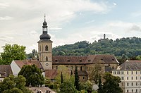 Sankt Jakob church, view from the north, Altenburg in the background, 2015 |
 Aufseesianum view from the north, 2015 |
| Mountain town | Immunity Michaelsberg with Abtsberg |
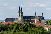 Michelsberg Monastery, view from Altenburg, 2014 |
 Villa Remeis view from the north, 2015 |
| Island city | Inner island city |
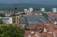 Parish Church of St. Martin, view from Michaelsberg, 2015 |
 Old town hall view from the south, 2015 |
| Island city | Island city expansions, northern and southern city expansions |
 Martyrdom at the western end of the pasture in 2015 |
 Former Post Office Directorate on Wilhelmsplatz, view from the southwest, 2015 |
| Theuerstadt | Lower nursery and northeastern urban expansion |
 Sebastian's Chapel, from the south, 2015 |
 Liebfrauensiechhaus, from the northwest, 2015 |
| Theuerstadt | Upper nursery and eastern urban expansion |
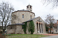 Church of the Redeemer, view from the south, 2013 |
 Steinweg 9, 2015 |
| Theuerstadt | Wonder castle and south-eastern city expansion |
 Maria Hilf Church, 2017 |
 Ulanendenkmal, 2017 |
| Incorporated places | Incorporated places |
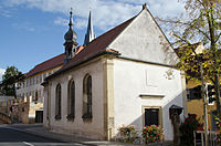 Gaustadt, St. Sebastian Chapel, 2015 |
 Bughof, 2015 |
Ensemble old town Bamberg
Bamberg's overall structure is that of an early medieval city : extensive, integrating older settlement centers as well as more recent developments, subject to a symbolic order - the shape of a cross - or at least interpreted in this way. This form overlaps the three urban regions into which Bamberg scenic and those following divided the historical circumstances accordingly: The mountain town , the island city and finally in the east the gardener city . With the river crossings, one of which is soon accentuated by the seat of the city regiment, the other has repeatedly been the subject of urban design considerations since the baroque bridge construction, the structures of the three city regions become knotted.
Fateful for the overall structure was the foundation of the Diocese of Bamberg by the German King Heinrich II. In 1007, prepared at the latest since 1004. Since this was by no means only to be seen as an act of church politics, but as an act of imperial politics, the idea that with the city a new Rome was to be founded. With the cathedral monastery , St. Michael and St. Stephan , the transverse axis of the system was established, which could be completed in 1058 with St. Gangolf and 1071 with St. Jakob zum Kreuz. This now made it possible to see the disparate settlement centers of Bamberg together as a city. The future fate of Bamberg as an open city was thus predetermined.
The three characterized city regions of Bamberg, which formed a loose and spacious urban structure as early as the 11th century, have grown together over time to form a denser unit without losing their historical and vivid character, especially since neither war losses nor more recent demolitions of the essentially obscure what has become historical. With this in mind, the old town of Bamberg was recognized by UNESCO as a World Heritage Site.
Mountain town
The mountain town is topographically characterized by the foothills of the Steigerwald sloping down towards the Regnitz with deeply cut valleys. Here the natural conditions for the construction of the castle were given, which can be assumed there since the 9th century at the latest. By founding the diocese , it should become the spiritual center not only of the city. The pens still shape the character of the mountain town today, enthroned at the end of the mountain ridges over the river and looking far into the valley. They form independent and partly fortified centers within the high medieval settlement landscape, which had their own sovereignty within the limits of their immunity districts and which remained special units in urban life. Even in today's structure of the mountain town, the development within the immunity areas, for example on Domberg, Jakobsberg and Stephansberg around the collegiate churches, is clearly visible. In the canons of St. Stephan and St. Jakob , the abandonment of the Vita Communis in the 12th century may have prompted the wreath of collegiate curiae, which still surrounds the collegiate churches and convent buildings today; The feet of the cathedral monastery and the St. Stephan monastery also had their own vicariate quarter. Due to its legal independence, the monastery also grew into its own suburbs, which is particularly clear with St. Stephan (Oberer Stephansberg) and St. Jakob, but also with the cathedral monastery with St. Theodor, Sutte and Matern. The bourgeois development near the river is initially pushed, follows the mountain ridge out of town and finally splits up into individual arms, in order to leave the slopes and valleys formerly to the viticulture (Häckersiedlung); a settlement structure that the Kaulberg has preserved in a characteristic way.
At the foot of the Domberg lies the upper -class quarter, which developed into a manor town on the basis of an early medieval traders' settlement , which has undergone a Baroque transformation in its late medieval and early modern buildings through the seats of the old families and the long-established nobility , who are connected in the court and cathedral chapter . The part of the city, which merges into the citizen town “Im Sand” in the north, was completed by the former city gate at the Elisabethkirche - between Oberer and Unterer Sandstraße. Enclosed by the wall was a small-scale craftsmen's area, which the name Sandbad already indicates its situation and history. In the south, this mansion was closed off tightly with the Jewish ghetto . It crossed the valley descending road, which led from the west, over the Kaulberg and probably also through the area of the farmyard belonging to the early medieval castle to the river crossing, creating bottlenecks that have been of historical significance to this day despite regrettable interventions since the 18th century stayed. Outside the former north gate, the petty-bourgeois sand suburb has undergone a significant modification in its original structure due to a fire during the Thirty Years War and the subsequent large-scale design in the former hospital area (now a hotel).
Island city
If the outline of the mountain area is irregular and, as it were, open, the island city is enclosed by the two main arms of the Regnitz. Its core, once surrounded by walls, has a typical high medieval urban structure with its two large market streets, probably also including an older settlement area. The two market complexes of the island city, Lange Straße and Green Market, the latter directly connected with a river crossing, argue about priority; By the 12th century at the latest, they existed side by side. In more recent times, the competitiveness of the Lange Straße was impaired by the fact that a second body of water had to be crossed between the city gate and Regnitz, where a river crossing only existed at times; This existed in 1335 as a long bridge, later only as a long bridge or Wunderburger bridge, a structure that had to be demolished during floods. The current course of the Königsstraße also shows that the development has taken no notice of the competition concerns of the Langen Straße. Only the 19th century brought a change here. Grüner Markt and Lange Straße, together with Kapuzinerstraße, Austraße and Keßlerstraße, shape the basic shape of the city center, converging like the fingers of a hand to the two town hall bridges. These five streets essentially subdivide the high medieval walled island town, which initially excluded the area around Alt-St.-Martin, Frauenstraße and outer Kapuzinerstraße. It was not until the late Middle Ages that this area was included in the outer wall girdle, characterized by the construction of the New Gate in front of Alt-St.-Martin in 1334. The late medieval walling of the island city is still evident today in the development of the front and rear ditches and the Kleberstrasse as well down along the promenade. There the houses are built on the partly still preserved old city wall or at least follow its course. The former moat is still clearly recognizable, often used as a garden, but also partly built over (Kleberstrasse odd numbers 1–53 with Holzmarkt 4, 6 and 8; Markusplatz 2 and 4, Markusstrasse odd numbers 1–21).
The Zinkenwörth lies in the south of the core of the island town as a separate area that was also independent under local authority law until the 18th century. Although it was poorly and properly connected to the city center in terms of traffic and defense technology in the 15th century and connected to the system of urban expansion in the late 19th century, it retained a lot of urban structural independence. The island city only expanded to the north and south in the 19th and 20th centuries; in the north in a modest, area-limited form, in the south initially in loose, upper-class villas, then in continuation of the long street with dense boulevards and secondary centers (Schönleinsplatz - Wilhelmsplatz), some of which are metropolitan. Thus, the 19th century with the Willy-Lessing-Strasse and the Luitpoldstrasse made the connection of the island town to the train station in the east possible and with the Marienbrücke built in 1889/90 the additional river crossing in the southeast required by the course of the Langen Strasse. In the early 19th century, the former alluvial forest south of the island town between the two arms of the Regnitz was redesigned into the Volksgarten. Immediately in front of the city, the Theresienhain and the Luisenhaun extend as far as the Bug district.
Gardening town
The gardening town east of the right Regnitz arm with its old center, the collegiate monastery St. Gangolf and its immunity district, ends with the hospitals in the north and the Wunderburg in the south. In contrast to the spiritually determined mountain town and the bourgeois island town, it offered and still offers a predominantly rural image with large, horticultural open spaces. Since the 14th century at the latest, the gardeners' settlements have been divided into the Theuerstadt and the buildings on the old Steinweg (today Nürnberger Straße, Obere and Untere Königsstraße and Siechenstraße), loosely with single-storey small houses, divided into Obere and Untere Horticulture and as such up to the recent village rivalries. In its present-day appearance, the gardening area is mainly characterized by the single-storey gardener's houses lined up in long chains, mainly from the 19th century, and the extensive cultures divided into elongated plots. What was formerly known as the entire length of the stone path, which leads long-distance traffic through the periphery of the city, increases the development towards its center and thus towards the river crossing to create an urban representation. Due to its great importance for traffic, the St. Gangolf monastery did not intervene in the course of this street for nothing with its immunity area; a topographical situation that could be due to a rivalry between the bailiwick and the church principality, which was striving for independence in the 12th century. The 19th century gave the gardening town a sharp border against modern Bamberg-Ost through the railway structure and, with the Luitpoldstraße leading to the train station, drew a splendid Wilhelminian axis across the old street directions. The location of the station, given the route, meant that the route from the station to the city center had to be a south-east bypass for urban development. Because when a continuous street was decided due to the population growth in the second half of the 19th century, the intentions of the time corresponded to the intentions of the time to lead this perpendicular to the train station, but at the same time to have it intersect at right angles with the Königsstraße. This also programmed the construction of a new bridge over the Regnitzarm and the city expansion in the southeast of the island city.
Former architectural monuments
This section lists objects that were previously entered in the list of monuments.
| location | object | description | File no. | image |
|---|---|---|---|---|
| Obere Gärtnerei Nürnberger Straße 67 a ( location ) |
Gardener's house | Free-standing two-storey saddle roof building, massive, probably from the 18th century | D-4-61-000-976 | |
| Stephansberg Alter Graben 18 ( location ) |
Stucco ceiling | On the first floor, around 1720 | D-4-61-000-10 | |
| Lower nursery Siechenstrasse 50 ( location ) |
Small house | Two-storey eaves gable roof construction, in the core 18th century, heightened probably in the early 19th century, corresponding facade on the upper floor preserved | D-4-61-000-1305 |
 more pictures |
See also
Remarks
- ↑ This list may not correspond to the current status of the official list of monuments. The latter can be viewed on the Internet as a PDF using the link given under web links and is also mapped in the Bavarian Monument Atlas . Even these representations, although they are updated daily by the Bavarian State Office for Monument Preservation , do not always and everywhere reflect the current status. Therefore, the presence or absence of an object in this list or in the Bavarian Monument Atlas does not guarantee that it is currently a registered monument or not. The Bavarian List of Monuments is also an information directory. The monument property - and thus the legal protection - is defined in Art. 1 of the Bavarian Monument Protection Act (BayDSchG) and does not depend on the mapping in the monument atlas or the entry in the Bavarian monument list. Objects that are not listed in the Bavarian Monument List can also be monuments if they meet the criteria according to Art. 1 BayDSchG. Early involvement of the Bavarian State Office for Monument Preservation according to Art. 6 BayDSchG is therefore necessary in all projects.
literature
Denis André Chevalley: Upper Franconia . Ed .: Michael Petzet , Bavarian State Office for the Preservation of Monuments (= Monuments in Bavaria . Volume IV ). Oldenbourg, Munich 1986, ISBN 3-486-52395-3 .
The art monuments of Upper Franconia in The art monuments of Bavaria :
- 3.1: City of Bamberg 1, city monument and monument landscape, 1st half volume: City development history . Edited by Thomas Gunzelmann, 2012, ISBN 3-89889-171-2
- 3.2: City of Bamberg 1, city monument and monument landscape, 2nd half volume: city monument . Edited by Thomas Gunzelmann, 2012, ISBN 3-422-07118-0
- 4.1: City of Bamberg 2, Domberg 1: The cathedral monastery. Part 1: Building history, building description, analysis . Edited by Matthias Exner , 2015, ISBN 978-3-89889-194-3 DNB 1028937059
- 4.2: City of Bamberg 2, Domberg 1: The cathedral monastery. Part 2: furnishings, chapter buildings, cathedral treasure . Edited by Matthias Exner , 2015, ISBN 978-3-89889-194-3 DNB 1072085003
- 5.1: City of Bamberg 3, immunities of the mining town, 1st quarter volume: Stephansberg . Edited by Tilmann Breuer, Reinhard Gutbier and Christine Kippes-Bösche, 2003, ISBN 3-422-03089-1
- 5.2: City of Bamberg 3, immunities of the mining town, 2nd quarter volume: Kaulberg, Matern and Sutte. Edited by Tilmann Breuer , Reinhard Gutbier and Christine Kippes-Bösche, 2003, ISBN 3-422-03090-5 .
- 5.3: City of Bamberg 3, immunities of the mining town, 3rd quarter volume: Jakobsberg and Altenburg . Edited by Tilmann Breuer, Reinhard Gutbier and Peter Ruderich, 2008, ISBN 3-422-06678-0
- 5.4: City of Bamberg 3, immunities of the mining town, 4th quarter volume: Michelsberg and Abtsberg . Edited by Tilmann Breuer, Christine Kippes-Bösche and Peter Ruderich, 2009, ISBN 3-422-06679-9
- 6.1: City of Bamberg 4, civil mining town, 1st half volume . Edited by Tilmann Breuer and Reinhard Gutbier, 1997, ISBN 3-422-00575-7
- 6.2: City of Bamberg 4, civil mining town, 2nd half volume . Edited by Tilmann Breuer and Reinhard Gutbier, 1997, ISBN 3-422-00575-7
- 7.1: City of Bamberg 5, Inner Inselstadt, 1st half volume . Edited by Tilmann Breuer and Reinhard Gutbier, 1990, ISBN 3-486-54591-4
- 7.2: City of Bamberg 5, Inner Inselstadt, 2nd half volume . Edited by Tilmann Breuer and Reinhard Gutbier, 1990, ISBN 3-486-54591-4
Web links
- Bamberg in the Bavarian Monument Atlas
- List of monuments for Bamberg (PDF) at the Bavarian State Office for Monument Preservation
- Monument Bamberg - Page with detailed information on Bamberg's monuments

