
List of architectural monuments in Würzburg
 Ensembles:
Old Town Würzburg •
Wittelsbacherplatz City district old town by street name: A • B • D • E • F • G • H • I • J • K • L • M • N • O • P • R • S • T • U • V • W • Z) Other districts: Dürrbachtal • Frauenland • Grombühl • Heidingsfeld • Heuchelhof • Lengfeld • Rottenbauer • Sanderau • Steinbachtal • Versbach • Zellerau |
The monuments of the Lower Franconian city of Würzburg are compiled on this page . This table is a partial list of the list of architectural monuments in Bavaria . The basis is the Bavarian Monument List , which was first drawn up on the basis of the Bavarian Monument Protection Act of October 1, 1973 and has since been managed by the Bavarian State Office for Monument Preservation . The following information does not replace the legally binding information from the monument protection authority. This list reflects the update status of November 11, 2015 and contains 728 architectural monuments.
Distribution according to city districts
There are over 700 monuments in Würzburg. Therefore, this list is divided into sub-lists for the individual districts of Würzburg . You can switch between the lists of monuments using a navigation bar sorted by the numbers of the city districts.
| No. | Borough |
|---|---|
| 01 | Old town |
| 02 | Zellerau |
| 03 | Dürrbachtal |
| 04 | Grombühl |
| 05 | Lindleinsmühle |
| 06 | Frauenland |
| 07 | Sanderau |
| 08 | Heidingsfeld |
| 09 | Hypocritical court |
| 10 | Steinbachtal |
| 11 | Versbach |
| 12 | Lengfeld |
| 13 | Rottenbauer |
Ensembles
Old town of Würzburg

The boundary of the Würzburg Old Town ensemble is defined on the right Main by the outer peripheral development of the Ringpark and on the left Main by the baroque fortifications of the Marienberg Fortress and the boundary of the park on the Nikolausberg. Parts of the bastionary fortifications around the city center and fortress built after the Thirty Years' War under Prince-Bishop Johann Philipp von Schönborn (1642–1673) from 1656 , which were largely abandoned after the fortress status of the city and castle were abolished in 1866, still exist to the east of the Würzburg Residence to the fortress and northwest of the Mainviertel.
The course of the baroque fortifications is still clearly recognizable in the floor plan of today's large city, the extent of which exceeds the old town by about four times, since the ring park was largely built on the old glacis from 1880 onwards . The baroque urban area of Würzburg goes back to the second expansion. The medieval town center, which is represented in the form of a miter on the right Main , was delimited by a bering along today's streets Juliuspromenade, Theaterstraße, Balthasar-Neumann-Promenade, Neubaustraße and Wirsbergstraße.
The later episcopal city of Würzburg has its origins in prehistoric times. Probably favored by the topographical location above the Main, the Marienberg was first settled by the Celts . From the 6th century on, the Volksburg was the seat of the Franconian-Thuringian dukes who ruled the surrounding area. Your last representative, Hetan II., Recorded 704 in castro wirteburch . The fortified place on the Marienberg remained the only reference point for settlement until around 700. Only in the course of the 8th century two new settlement areas emerged: Left Main, below the castle with the foundation of an Andreas monastery and Right Main around a Franconian hall courtyard and the adjoining grave chapel of St. Kilian . The monastery of St. Andreas (later St. Burkard ) was founded by the first bishop of Würzburg, who was ordained in 742/43 , St. Burkard . The burial chapel of St. Kilian was built on the alleged site of the martyrdom of the Irish missionary and his companions Totnan and Kolonat . The core of the settlement around the chapel must be seen as a growth cell of the later city, first attested as a civitas in 1030 .

This bipolarity of the castle and the center of the Right Main settlement (with Salvatordom above Kilian's grave), which was already recognizable in the Carolingian - Ottonian times, took on its first weight in the 11th century, when monasteries and monasteries began to shape the specifically spiritual character of the city. At the same time, in 1045 under Bishop Adalbero, the Neumünster Abbey was built over the grave of St. Kilian and next to it the new Kiliansdom with the Salic Triumphal Road from the Main. This Triumphalstraße (it was also the market with the so-called Grafeneckartbau as the seat of the mayor and burgrave) and the cathedral formed the heart of the up-and-coming city. So far, this facility can only be compared with the situation in front of the Speyer Cathedral and documents the close connection to the Salian and later Staufer imperial family. With the possession of several counties, the bishops came to sovereign power early, whereby they could invoke the 1168 formally recognized by Emperor Frederick I claim to the ducatus Franciae orientalis . The bishops, whose sphere of influence was initially limited to the area of the Salvatordome, gained sovereignty over the previously royal city in the 10th and 11th centuries with jurisdiction. In the first half of the 11th century, the monastery of St. Peter and Stephan (Petersgasse) and outside the city wall (at today's train station ) the Haug monastery and, on the other side of the Main, next to the older Andreas monastery , the Burkardus monastery. Abbey and monasteries with their own legal immunity districts, but also remnants of the agrarian settlement association in the immediate vicinity of the city, have been starting points for new suburban settlements since the 11th century.
This development continued in the 12th and especially in the 13th century: the so-called Scots monks settled in the Jakobskloster with the still-preserved towers of the Romanesque basilica in 1146 on the left Main, while the Mühlenviertel on the Pleichach with its parish church was built on the right in the first half of the 12th century St. Gertraud (before 1133, rebuilt in 1613). In the meantime, the two opposite settlement areas, the core city and the Mainviertel, had to be finally connected: In the early 12th century, the Old Main Bridge was built as a stone bridge as an extension of Domstraße, which had served as Marktstraße since 1328. The aim here was to win over the bipolar areas for an entire urban area.
New religious settlements on the outskirts of the Ottonian city center, whose pastoral care was aimed at the now socially richer, differentiated city population, enriched and changed the overall image of the city in the 13th century. The Carmelites founded their monastery near the old Nikolauskirche on the banks of the Main, the German rulers who came into the ownership of the royal court in the Mainviertel (attested since 1219, church completed in 1296), the Franciscans in 1221 on Franziskanerplatz, the Dominicans in 1239 on Dominikanerplatz (today Augustinerkirche ) , for whose church building Albertus Magnus laid the foundation stone in 1264–1266 , and the Augustinian Hermits in 1262 in today's Augustinerstraße (formerly Rittergasse). From around 1200 the canons' courts were built around the Neumünster Cathedral and Abbey as a kind of aristocratic mansion with an independent area. They have been continuously expanded until modern times.
With the gradual enlargement of the city and the increase in its different population strata, the self-confidence of its citizens also awakened: It was evident in attempts to free themselves from the dictates of the all-powerful bishops, who in the 13th century saw themselves forced to move to that of Bishop Hermann I of Lobdeburg (1225–1234) to relocate an expanded fortress. From this point on, this was a symbol of episcopal power. The attempts of the citizens to come of age finally failed - until the end of the episcopal rule under Karl Georg von Fechenbach with the defeat at Bergtheim in 1400.
At this time, the cityscape of late medieval Würzburg had shaped its face after a spacious market square was created in the numerous narrow and multi-winding streets with the destruction of the Jewish quarter in 1348. Here the citizens built the Marienkapelle as the only contribution to the church building in the city from 1377 , with the aim of becoming the second center of the city as a great hall church in competition with the cathedral. Furthermore, the citizens of Würzburg in 1319 built outside the walls of the Civic Hospital and created their own facilities.
The image of the late medieval city structure with its walled miter-shaped form - apart from the building complex of the Old University, which was built under Julius Echter von Mespelbrunn in place of the Ulrich monastery - was preserved until the Baroque period. This picture was determined by the bipolarity of fortress and residential area (on both sides of the Main) with the church center around the cathedral. This bipolarity, which is still recognizable today, is explained by the favorable topographical location of the city on the Main, while at the same time being surrounded by vineyards. It is at the same time a visible expression of the dependency between the all-powerful prince-bishop and the citizen who is regarded as underage.
The tension between the clergy and the townspeople reached their climax in the battles of the Peasant War in 1525, in which the citizens took part (including Tilman Riemenschneider , mayor of the town and the most important Franconian sculptor of his time). After the end of the uprising, which was also waged as a religious war, the power of the prince-bishop was re-established. The site of the fighting was the area around the fortress. In the second half of the 16th century, at the beginning of the Counter-Reformation , the Jesuits under Prince-Bishop Friedrich von Wirsberg settled in Würzburg in 1567, who further promoted the renewal of the faith. The Michaelskirche (the first building from 1606-1610) was her contribution to the architecture in the city.

Large structures - the last before the residence was built - were built under Prince-Bishop Julius Echter von Mespelbrunn (1573–1617), who is considered the main initiator of the German Counter-Reformation and who financially and religiously renovated Würzburg and Franconia during his autocratic reign. The Old University (1582) is an expression of his spiritual and religious educational efforts with the new church originally richly furnished in Renaissance form as the grave church of the builder (consecrated in 1591, renovated under Antonio Petrini ). The Old University, built on the site of the late Gothic Ulrichskloster, was the first building complex built as a university on German soil. The visual relationship between the fortress, the university and the Church of the Holy Sepulcher, specifically requested by Julius Echter, has been preserved to this day. Outside the late medieval city walls, Echter had the Juliusspital built as the second social institution for the city in 1576 . His third major construction work in Würzburg was the castle-like expansion of the fortress in 1600, as it is largely presented today. Finally, Echter rebuilt the St. Gertraud Church in Pleich. This new building resulted in an interesting relationship between churches: the towers of St. Gertraud, the Marienkapelle on the market square and the new church are on one axis, as are the tower of the new church, the tower of St. Burkard and the dome of the Marienkirche the fortress (built around 1000).
After the destruction of the Thirty Years' War - the biggest loss was the robbery of the Echter library by the Swedes in 1631 - lively construction activity began under Prince-Bishop Johann Philipp von Schönborn (1642–1673). His main achievement was the girdling of the simultaneously expanded city and the fortress with the massive bastion fortifications, which took place from 1656 onwards. However, Haug Abbey with its Romanesque basilica had to give way. For this purpose, the early Baroque building of the new collegiate church was erected at its current location under the direction of the Northern Italian master builder Antonio Petrini. Numerous other buildings in the city can be traced back to this important master builder from around 1700, such as the first baroque building in Würzburg, the so-called Reuererkirche (new construction of the Carmelite Church), the redesign of the Juliusspital and the new church or the Rosenbachhof, which was later incorporated into Residenzplatz.

This baroque reshaping of the richly structured medieval city, which began here, continued to an increasing extent in the course of the 18th century. Above all through the residence building of the Schönborns from 1720, through which the seat of the prince-bishops was moved back to the city, the claim of the absolute prince, which is taken for granted, is represented. In fact, up to the time of Friedrich Karl von Schönborn , the Schönborn family played an essential part in imperial politics.
After 1700, Prince-Bishop Johann Philipp von Greiffenclau zu Vollraths (1699–1719) gave the cathedral, the Neumünster collegiate church and the Peterskirche their baroque design. Johann Philipp Franz von Schönborn (1719–1724) then continued the rich building program with his famous master builder Balthasar Neumann (1687–1753). In addition to the construction of the residence, in which Maximilian von Welsch , Lucas von Hildebrandt , Germain Boffrand and Robert de Cotte were also involved, underlining the international rank of this palace with its chapel, the courtyard garden that was later laid out and the Residenzplatz design, which can still be traced back to Neumann, The so-called Käppele was built as a pilgrimage church on Nikolausberg (1747–1750), the Schönborn grave chapel at the cathedral in view of the residence and the new construction of the Michael’s church by Johann Michael Fischer from 1765. Balthasar Neumann also acted as a city planner in Würzburg: Walk on him the layout of the great promenades around the former late medieval Bering and the breakthrough of the Hofstrasse back. In addition, he created the space in front of the so-called Grafeneckartbau, where the famous four-tube fountain stands, through renovations and new constructions. The pipe system of the running water supply that was set up in 1733, which is still partially functioning today, also goes back to Neumann.
The baroque residence city of Würzburg now presented itself as rich in church towers, which essentially determine the cityscape, and rich in mutual visual relationships between the important buildings as structuring elements in the city. The extent of the city with the bastion fortifications existed until around 1880. Under the last Prince-Bishop Georg Karl von Fechenbach (1795-1808), the French revolutionary armies invaded the diocese. During the battles for the city, the 17th century bastionary fortifications proved their worth again: The fortress had to be conquered.

The secularization ended the spiritual rule over the Hochstift Würzburg in 1803 by handing it over to the Electorate of Bavaria . In the 19th century, Jens Person Lindahl built the Ringpark from 1880 onwards, in addition to the two associated bridges ( Friedensbrücke and Ludwigsbrücke ), some public buildings, such as the New University on Sanderring 1892–1896; In the city center, however, there were no more significant changes. The ring park on the old glacis, originally laid out as an artistically designed, path-rich recreation park, with its outer peripheral development was intended to serve as a link between the core city and the newly emerging districts of Grombühl, Frauenland and Sanderau. During this time of the gradual expansion of the urban area, the baroque urban space remained almost untouched and clearly delimited.
The pilgrimage church of the Visitation of the Virgin Mary, the so-called Käppele , with the ascent lined with stations of the cross, stands in a corresponding visual relationship to the Würzburg old town . Although it was originally clearly characterized as a pilgrimage church "outside the city" due to its location outside the city center and the fortress, after the creation of the recreation park on Nikolausberg (around 1885–1900) with the Frankenwarte vantage point, it was given a new urban function : It was included as a structural dominant in the urban area that suddenly developed into the landscape.
The park on Nikolausberg, which emerged from the tradition of garden art of the late 19th century, complements the Ringpark. The system goes back to the operation of the Würzburg Beautification Association and a private initiative. At its lower northeast end, the facilities are initially still lined with the development of high-quality rental villas in Leistenstraße and bourgeois villas in Mergentheimer Straße and are then structurally marked further up by the Käppele. The park continues to develop as an open landscape garden rich in paths with light deciduous forests, bush planting and deliberately planned open spaces (views of the fortress) up to the Frankenwarte; This lookout tower (1893/94) crowns the towering Nikolausberg and represents a Lug-ins-Land that emerged from a late romantic disposition . With the widely famous design of the Nikolausberg, Würzburg received a generous urban landscape with a special character at the turn of the century, which is reflected in the surrounding natural landscape embeds.
Although about 80% of the historic building stock was destroyed in the bombing of Würzburg on March 16, 1945 , the reconstruction up to around 1965 was carried out carefully and with consideration for the historically grown character of the old town, so that the old, deliberately planned visual relationships between large buildings and the The effect of the urban accents, the medieval streets and the baroque promenades were essentially retained. The former chimney of the thermal power station at the old harbor, the skyscraper at the Jahnstrasse, the post office building at the train station, the buildings of the Hypobank and the Sparkasse in the Hofstrasse, the new buildings (especially the apartment block) on the left bank of the Main between Deutschhauskirche represent or represent decisive disturbances of the cityscape and Schottenkirche, the rebuilding of Kaiserplatz and Franziskanerplatz. The X-ray ring, which was developed as a high-speed and long-distance road, and the Berliner Platz created with a roundabout must be mentioned as disruptive interventions that run counter to the original intention to create the ring park. File number: E-6-63-000-1.
Wittelsbacherplatz

The semicircular layout of Wittelsbacherplatz ( location ) was designed as a forecourt to the monumental building of the Pedagogical University and is axially related to it. The semicircle is built on with residential buildings from the 1920s, which, with their restrained formal language, are subordinate to the dominant school building. The Seinsheimstrasse, which joins the central axis, with its trees and houses 13 and 20b / 22 contributes to the square ensemble. File number: E-6-63-000-2.
City fortifications
Wurzburg
There are different wall sections of the different city extensions with round or semicircular towers in unplastered quarry stone masonry from the 13th / 14th. Century, in the area of the core city above foundations from the early 11th century, preserved at the following addresses:
- Balthasar-Neumann-Promenade 4 a ( location )
- Bohnesmühlgasse
- Kettengasse 9, 11 ( location )
- Kettengasse 13, 15 ( location )
- Kettengasse 17 ( location )
- Koellikerstraße 15 ( location )
- Rotlöwengasse 2
- Rotlöwengasse 4 ( location )
- Tiepolostraße ( location )
- Kennel ( location )
- Kennel 4 ( location )
- Kennel 12 ( location )
- Kennel 18 ( location )
The tumes preserved are as follows:

- so-called "cutting tower " ( location ), formerly northwest corner tower, high square tower with pyramid roof, 13th / 14th centuries. century
- So-called "Hexenturm" ( location ), formerly southeast corner tower, high round tower with a protruding upper floor and conical roof, 14th century
- So-called "Hirtenturm" ( location ), formerly southwest corner tower, square tower with gun battlements and elevated pyramid roof, after 1525 over foundations of the 13th century, renewed in the 17th century, rebuilt after being destroyed in the war, with remnants of the wall
File number: D-6-63-000-4.
The medieval bank fortification was included in the city fortifications and has been preserved at the following addresses:
- Büttnerstrasse 64, 66, 68 ( location )
- Büttnerstrasse 72 ( location )
- Oberer Mainkai 1 (The upper Mainkai was built between 1872 and 1877)
- Oberer Mainkai 9 ( location )
Fortifications with bastions were built in the Baroque period.
| location | object | description | File no. | image |
|---|---|---|---|---|
| Dreikronenstrasse; Leonhard-Frank-Promenade ( location ) |
Bank reinforcement on the left side of the Main | Embankment wall with the remains of four bastions and the newly built foundations of the former thick tower , limestone, second half of the 17th century
walled coat of arms stone of Prince-Bishop Johann Gottfried von Guttenberg , sandstone, inscribed "1696" Relief of the coat of arms of Prince-Bishop Johann Gottfried von Guttenberg von Greifen, sandstone, end of the 17th century, in a new arrangement |
D-6-63-000-105 | |
| Fred-Joseph-Platz 1 ( location ) |
Burkarder Tor, city gate | Curved gate passage of the bastionary fortifications, strongly structured rustic portal with heraldic tympanum on the field side, simple round arch portal with grimacing keystone and oculus window on the town side, limestone and sandstone, baroque, Antonio Petrini, 1680
Associated bridge, seven-bay arched bridge, limestone, baroque, around 1750 |
D-6-63-000-87 |

|
| Fred-Joseph-Platz 1 ( location ) |
Remains of the bastionary fastening belt on the left side of the Main | With two preserved city gates (Zeller and Burkarder Tor), bastions, curtains and associated Contrescarpe, embankment walls with embedded heraldic stones, baroque, second half of the 17th century | D-6-63-000-394 | |
| Schottenanger 15 ( location ) |
Bastion of the baroque city fortifications | With coat of arms of Prince-Bishop Johann Philipp von Schönborn, inscribed "1666" | D-6-63-000-537 | |
| Zeller Strasse ( location ) |
So-called Zeller Tor, city gate | Curved gate passage in the bastionary fortifications, rustikaportal gabled on the field side with coat of arms relief and attached guard house, on the town side simple rustic arch with grimacing stone, early baroque, limestone and sandstone, inscribed "1666"
Remainder of the associated arch bridge with a preserved arch and another arch attachment, limestone, around 1750 |
D-6-63-000-639 | |
| Near Residenzplatz ( location ) |
Hofgarten, with the corresponding sections of the bastion fortifications | Baroque, second half of the 17th century | D-6-63-000-198 |
Heidingsfeld
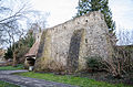
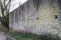
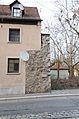
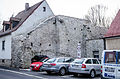
The city wall of the former imperial city of Heidingsfelde consists of half pillars along the inside, on the west and south sides narrow round towers at regular intervals that appear in the upper part of the wall outside like a bay window, two semicircular protruding towers and, on the highest elevations, two stronger round towers with conical roofs (Stegenturm in the west and Salmannsturm in the east), at the entrance and exit of the Heigelbach through the city wall two bridge structures with battlements and gable roofs, remains of the two-sided walling of the Heigelbach within the city walls, remains of the Nikolaustor, unplastered limestone. It was built from 1368 onwards, completed in the 15th century, changes in the 17th century, demolition of the gates and some parts of the wall in the second half of the 19th century, already before that, demolition of the walls and filling of the trenches, war damage in 1945, reconstruction until 1978 79. File number: D-6-63-000-5. Pictures .
Clockwise starting at Nikolaustor there are the following sections of the city wall that have been preserved:

Nikolaustor, field side

Nikolaustor, coat of arms of the imperial city Heidingsfeld

Wenzelstraße 26, field side

Wenzelstraße 20, field side

Wenzelstrasse 14 to 3, field side

At the storage hole, field side

Seegartenweg 3, field side
Seegartenweg, field side

Seilerstrasse, field side

Northeast corner tower, field side

Werkingstrasse, field side
Werkingstrasse, field side

Werkingstrasse, city side

Werkingstrasse, breakthrough on the city side
Klosterstrasse 43

Salmannsturm

Glacisweg, wall tower, field side

Glacisweg, wall tower, field side

Glacisweg, wall tower, field side

Glacisweg, wall tower, city side

Glacisweg

Glacisweg

Glacisweg

Stengerstrasse, south side of the city
Stengerstrasse, north side of the city

Bridge tower

Stegenturmgasse, field side

Stegenturmgasse, city side

Reuterstraße, field side

Reuterstraße, field side

Reuterstraße, field side

Reuterstraße, breakthrough Dolgasse

At the city wall 1, field side


| location | object | description | File no. | image |
|---|---|---|---|---|
| Wenzelstrasse ( location ) |
Nikolaustor | City gate, remainder of the inner wall gate from the former Nikolaustor; Arched opening with stone hinges of the former gate wing and stepped gable, on the field side a niche with neo-Gothic framing and relief with double coat of arms (double-headed eagle and standing lion), Gothic, second half 14th / 15th century. Century, changes after partial demolition in the second half of the 19th century | D-6-63-000-356 |
 more pictures |
Remarks
- ↑ This list may not correspond to the current status of the official list of monuments. The latter can be viewed on the Internet as a PDF using the link given under web links and is also mapped in the Bavarian Monument Atlas . Even these representations, although they are updated daily by the Bavarian State Office for Monument Preservation , do not always and everywhere reflect the current status. Therefore, the presence or absence of an object in this list or in the Bavarian Monument Atlas does not guarantee that it is currently a registered monument or not. The Bavarian List of Monuments is also an information directory. The property of a monument - and thus the legal protection - is defined in Art. 1 of the Bavarian Monument Protection Act (BayDSchG) and does not depend on the mapping in the Monument Atlas and the entry in the Bavarian Monument List. Objects that are not listed in the Bavarian Monument List can also be monuments if they meet the criteria according to Art. 1 BayDSchG. Early involvement of the Bavarian State Office for Monument Preservation according to Art. 6 BayDSchG is therefore necessary in all projects.
literature
- Denis André Chevalley: Lower Franconia . Ed .: Michael Petzet , Bavarian State Office for the Preservation of Monuments (= Monuments in Bavaria . Volume VI ). Oldenbourg, Munich 1985, ISBN 3-486-52397-X .
further reading
- Stefan Kummer : Architecture and fine arts from the beginnings of the Renaissance to the end of the Baroque. In: Ulrich Wagner (Hrsg.): History of the city of Würzburg. 4 volumes; Volume 2: From the Peasants' War in 1525 to the transition to the Kingdom of Bavaria in 1814. Theiss, Stuttgart 2004, ISBN 3-8062-1477-8 , pp. 576–678 and 942–952.
Web links
- Bavarian Monument Atlas (cartographic representation of the Bavarian architectural and ground monuments by the Bavarian State Office for Monument Preservation (BLfD) )
- List of monuments for Würzburg (PDF) at the Bavarian State Office for Monument Preservation
Individual evidence
- ^ Bruno Rottenbach: Würzburg street names. Volume 1, Franconian Society Printing Office, Würzburg 1967, p. 41 f. ( Domstrasse ).
- ^ Bruno Rottenbach: Würzburg street names. Volume 1, Franconian Society Printing Office, Würzburg 1967, p. 43.
- ^ Horst-Günter Wagner : The urban development of Würzburg 1814-2000. In: Ulrich Wagner (Hrsg.): History of the city of Würzburg. 4 volumes, Volume I-III / 2, Theiss, Stuttgart 2001-2007; III / 1–2: From the transition to Bavaria to the 21st century. Volume 2, 2007, ISBN 978-3-8062-1478-9 , p. 1299, note 26.
Amberg | Ansbach | Aschaffenburg | Augsburg | Bamberg | Bayreuth | Coburg | Erlangen | Fürth | Yard | Ingolstadt | Kaufbeuren | Kempten (Allgäu) | Landshut | Memmingen | Munich | Nuremberg | Passau | Regensburg | Rosenheim | Schwabach | Schweinfurt | Straubing | Willows in the Upper Palatinate | Wurzburg