List of rivers in South Sudan
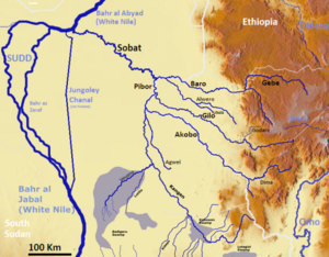
The list of rivers in South Sudan includes the main rivers of South Sudan . With 98% of the country's surface, South Sudan is almost entirely determined by the hydrology of the Nile (excluding the Ilemi triangle ). The border with the Central African Republic is practically identical with the watershed boundary for Congo . Here is also the region with the most rainfall in the otherwise arid country . Evaporation is so high that endorheic depressions like the Ambadi , theAbu Shanab or Lake Maleit .
There are three distinctive hydrological variables to be mentioned:
- The catchment area of the Bahr al-Ghazal , which is the largest sub-basin of the Nile in terms of area, but contributes little water to the Nile due to the high level of evaporation.
- The Sudd , which is one of the largest wetlands in the world.
- The Sobat catchment area, which is fed from Ethiopia and contributes over 10% of the water to the Nile at its mouth.
In the following, the rivers are sorted by catchment area and alphabetically.
According to catchment areas
Sobat
Bahr al-Ghazal
- Bahr al-Arab
-
Sue-Jur
-
Woof
- Busseri
- Numatinna
- Tonj
-
Woof
Nile
Alphabetical
A - G
- Vein
- Adda ( Kafia Kingi )
- Agwei
- Akobo
- Bahr al-Arab
- Bahr al-Jabal
- Bahr al-Ghazal
- Bahr el Zeraf
- Baro
- Bili
- Biri
- Boro
- Busseri
F - P
- Numatinna
- Nyanding
Q - Z
- Tonj
- Thui
- Umbelasha (Kafia Kingi)

