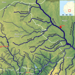
List of rivers in Burkina Faso
This is a list of the rivers in Burkina Faso . Burkina Faso is divided into three catchment areas. The north-east and a small part in the west (together 28% of the country's area) drains into the Niger, which are mostly seasonal rivers. The largest part (2/3) of the country, however, belongs to the Volta system. All four main tributaries of the Volt originate or have tributaries from Burkina Faso. The southwest drains over the Comoé to the south.
The amount of precipitation varies from 300 to 1300 mm. In total, the West African country receives 165 km³ of precipitation per year, of which only 9 km³ are runoff.
Volta (Ghana)
Oti (Pendjari)
Black Volta (Mouhoun)
White Volta (Nakambé)
Niger (river)
Further
Catchment area division
Catchment area distribution of the country in percent:
| Rivers | km² | Percent of the country's area |
|---|---|---|
| Volta | 178,000 | 63.0 |
| Niger | 77,314 | 28.0 |
| Comoé | 18,686 | 9.0 |
| total | 274,000 | 100 |


