List of cultural monuments in the municipality of Timmerlah-Geitelde-Stiddien
The list of cultural monuments in the Timmerlah-Geitelde-Stiddien district includes the cultural monuments in the Timmerlah-Geitelde-Stiddien district of Braunschweig , based on the Braunschweig guidance and information system BLIK, publications by the Braunschweig monument protection authority , the Federal Republic of Germany monument topography and the Lower Saxony monument atlas.
Cultural monuments
| image | designation | location | description | construction time | Registered since |
Monument number |
|---|---|---|---|---|---|---|

|
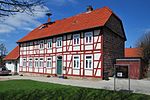
Old village smithy |
Timmerlah Timmerlahstrasse 110 map |
Former half-timbered forge, which was converted into a restaurant in the 19th century. | |||
| Old town center |
Geitelde An der Wasche card |
The old town center of Geitelde with old farms. Part of the Geitelde ensemble. | ||||
| Old town center |
Timmerlah Black Road map |
The old town center of Timmerlah with central German three-sided farms. Part of the Timmerlah ensemble. | ||||

|
Former school, rectory |
Stiddien Stiddienstrasse 11 map |
Former school, built in 1849. | 1849 | 36007784 (36001052) |
|
| Preserved farmhouses |
Stiddien Obere Dorfstrasse, Untere Dorfstrasse map |
Several old farmhouses on Obere Dorfstrasse and Untere Dorfstrasse. | ||||
| Courtyard at An der Wasche 1 |
Geitelde An der Wasche 1 card |
35998704 |
||||
| Hofanlage An der Wasche 9 |
Geitelde An der Wasche 9 card |
36001069 |
||||
| Pothof farm complex 6 |
Geitelde Pothof 6 map |
35998771 |
||||
| Hofanlage Steinbergstrasse 6 |
Geitelde Steinbergstrasse 6 map |
35998787 |
||||

|
Geitelde Church |
Geitelde Geiteldestraße 38 map |
Classicist building from 1807. | 1807 | 36856138 |
|

|
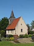
Church Stiddien |
Stiddien Stiddienstrasse 11 map |
First mentioned in 1220. Expansion before the Reformation. 1715 Insertion of arched windows and a baroque pulpit altar wall. | 36007760 (36001052) |
||

|
Churchyard Stiddien |
Stiddien Stiddienstrasse 11 map |
36856880 (36001052) |
|||

|
Timmerlah Church |
Timmerlah Kirchstrasse 11 map |
Single-aisled neo-Romanesque brick building from 1871. The west tower partly contains substance from the 14th century. In 1799 the church tower received its onion dome. | 1871 | 36867178 |
|
| barn |
Geitelde Geiteldestraße 36 map |
36856113 |
||||
| Wölbackerbeet |
Geitelde card |
Wölbacker in Geitelder Holz | 28959300 |
|||
| Residential building Obere Dorfstrasse 5 |
Stiddien Obere Dorfstrasse 5 map |
Old farmhouse | 36856368 |
|||
| Residential building Raiffeisenstrasse 1 |
Geitelde Raiffeisenstrasse 1 map |
36866734 |
||||
| House Steinbergstrasse 2 |
Geitelde Steinbergstrasse 2 map |
36866708 |
The following objects could not be a cultural monument despite being mentioned in the BLIK:
| image | designation | location | description | construction time | Registered since |
Monument number |
|---|---|---|---|---|---|---|
| Geitelder Berg |
Geitelde Am sender card |
The highest point in Braunschweig with a height of 110.9 meters. Part of the Geitelde ensemble. |
literature
- Wolfgang Kimpflinger: Monument topography Federal Republic of Germany . Architectural monuments in Lower Saxony. Volume 1.1 .: City of Braunschweig. Part 1. CW Niemeyer Buchverlage, Hameln 1993, ISBN 3-87585-252-4 .
- Wolfgang Kimpflinger: Monument topography Federal Republic of Germany. Architectural monuments in Lower Saxony. Volume 1.2 .: City of Braunschweig. Part 2. Verlag CW Niemeyer, Hameln 1996, ISBN 3-8271-8256-5 .
