
List of tributaries of the Alb (Upper Rhine)
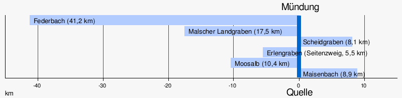
The Northern Black Forest Alb has a length of 51.4 km and a catchment area of 446.7 km². Quite exactly half the length and a little less than half of the catchment area are in the Black Forest and its foothills, the other part in the Upper Rhine Plain . Only two tributaries in the Black Forest, Maisenbach and Moosalb , and three more that flow into the lowlands, Scheidgraben , Malscher Landgraben and Federbach , exceed a length of five kilometers. The last two drain a large part of the southern catchment area in the lowlands in an often artificial trench.
diagram
Alb tributaries with a length of 5 km and more.
Detailed list of tributaries
- Hierarchical list of tributaries and
 lakes from source to mouth. Water lengths usually according to LUBW-FG10 (data record entries), catchment areas according to LUBW-GEZG, lake areas according to LUBW-SG10, height information according to the contour image on the geodata viewer. Other sources for the information are noted.
 - Mill channels are usually not mentioned.
Source of the northern Black Forest Alb in the Albursprung about 5.5 km south of Bad Herrenalb between the mountains Teufelsmühle in the west and Lerchenstein in the east in the Axtloch at about 743 m above sea level. NN . From here on north run.
Tributaries in the Black Forest
- Hülsgraben , from the right immediately after the Plotzsägmühle at about 525 m above sea level. NN , 2.443 km and 1.628 km². Arises north of the Lerchenstein at about 793 m above sea level. NN and runs on a section parallel to the contour lines.
- Kuhnsbach , from the left in the valley direction Geigerslöchle in an almost one kilometer long tributary on the left slope at about 438 m above sea level. NN , 1.233 km. Rises from the Rissbrunnen just above a clearing at the Risswasenhütte at about 600 m above sea level. NN .
- Rennbach , from the left on the southwestern outskirts of Bad Herrenalb at 375.8 m above sea level. NN , 2.817 km and 6.744 km². Rises about three kilometers west of Bad Herrenalb between Mauzenberg and High trough the race well at about 500 m above sea level. NN .
- Geißbach , from the right in the Herrenalber Kurpark at about 370 m above sea level. NN , 4.117 km and 8.525 km². Arises east of Herrenalb-Zieflensberg at about 630 m above sea level. NN .
- Dobelbach , from the right in Herrenalb after the thermal bath at 340 m above sea level. NN , 2.528 km and 8.176 km². Rises from a spring about two kilometers east of Herrenalb between the associated Rotensol and the neighboring municipality of Dobel at about 465 m above sea level. NN .
- Bernbach , from the left on the northern edge of Herrenalb at the Kullenmühle at 331 m above sea level. NN , 3.317 km and 4.592 km². Arises on a slope between Herrenalb-Bernbach and the Mauzenberg in the southwest of the district from the combined outflows of Upper , Middle and Lower Eckkopfquelle that at about 570- 550 m above sea level. NN lie.
- Maisenbach , from the right near Marxzell to just under 250 m above sea level. NN , 8.867 km and 17.080 km². Rises as Feldrennacher Bächle from the Seelachbrunnen east of the Straubenhardter Holzbachsägmühle at about 524 m above sea level. NN .
- Mastbrunn Siegen , from the right after the Marxzeller Gertrudenhof to a little below 220 m above sea level. NN , 2.623 km. Arises east of the Pfaffenrot district at about 355 m above sea level. NN .
- Katzenbach , from the right on the municipal boundary between Marxzell and Karlsbad to a little over 220 m above sea level. NN , 3.683 km. Arises south of the Jakobsbrunnen at Gewann Pfaffenroter pond west of Karlsbad- Ittersbach at about 344 m above sea level. NN .
- Moosalb , from the left on the municipal boundary between Marxzell and Ettlingen near Fischweier at around 207 m above sea level. NN , 10.404 km and 27.704 km². Rises southeast of the Gaggenau high hamlet Moosbronn from the Hüttlesbrunnen at about 479 m above sea level. NN .
- Bach from the Alt Siegenklamm , from the right in the valley widening of the Dennicher valley to about 197 m above sea level. NN , 0.878 km. Arises west of Karlsbad- Spielberg in the uppermost hillside forest at about 306 m above sea level. NN .
- Waschbach from the Windwiesenklinge , from the left almost opposite the previous one in the left branch Denningertalbach at about 196 m above sea level. NN , 1.921 km. Rises from a spring in the corridor of the same name south of Ettlingen- Spessart at about 320 m above sea level. NN .
- Stream from the Striedenklinge , from the left at Waldbronn -Neurod at around 205 m above sea level. NN , 1.236 km. Rises east of Spessart from a spring in the Wiesengewann Strieden at about 305 m above sea level. NN .
- Inflow from the Etzenroter Klamm , from the right at the Waldbronn- Etzenrot stop of the Albtalbahn at about 280 m above sea level. NN , 2.739 km. Arises in the Holderäcker corridor east of the Spielberg train station at about 339 m above sea level. NN .
- Bach through the Eselsklinge , from the left at the sewage treatment plant below the Ettlinger Kochmühle at about 175 m above sea level. NN , 1.654 km. Arises at the cemetery in the northeast of Spessart at about 294 m above sea level. NN .
- Bach through the Steigenklinge , from the left into a left Mühlkanal opposite the Waldbronn- Busenbach train station at about 175 m above sea level. NN , 1.146 km. Rises from a spring on the edge of the Rüppich forest north of Spessart at about 305 m above sea level. NN .
- Hetzelbach , from the right at the Busenbach train station at about 165 m above sea level. NN in the Alb itself, 3.472 km and 4.909 km². Arises east of Etzenrot at the edge of the forest to the Espich bay at about 285 m above sea level. NN .
- Bach from the Detschenklinge , from the left towards the beginning Ettlinger industrial park in the valley floodplain at about 160 m above sea level. NN , 1.049 km. Arises in the upper slope forest at about 305 m above sea level. NN .
- Hasengraben , from the right near the spinning mill stop of the Alb Valley Railway in Ettlingen at about 155 m above sea level. NN , 1.577 km. Arises in the corridor north of Busenbach at about 250 m above sea level. NN and first flows through the Hasenklamm , in order to then take up the Kalbergraben from the longer Kalberklamm , which rises approximately to the north and 25 m higher . From this tributary south-south-west.
- Krebsbächle , from the left before the Bad in Ettlingen stop at less than 150 m above sea level. NN , 2.810 km and 2.675 km². Arises on the northwestern edge of Spessart at about 320 m above sea level. NN . At this tributary opposite the Wattkopf , the Alb emerges from the Black Forest after almost exactly half of its course in the Ettlingen urban area.
Tributaries in the Upper Rhine Plain
- Exit of the Erlengraben , to the left in front of the former sewage treatment plant on the northwestern outskirts of Ettlingen at about 120 m above sea level. NN , which later continues under the names Hertelgraben and Petergraben , total length 5.472 km. From here north run.
- Oberholzgraben , to the left in front of the Salmenwiesen opposite Karlsruhe - Rüppurr at about 115 m above sea level. NN , 2.558 km. Connects to the Hertelgraben , in which it is at the northern tip of the forest area Forstlach near Karlsruhe- Weiherfeld at a little below 115 m above sea level. NN flows.
- Reiherbach , from the left between Weiherfeld on the left and Karlsruhe- Dammerstock on the right , 1.319 km. Left side ditch that goes off after the Salmenwiesen opposite Rüppurr.
- Scheidgraben , from the right south of the tracks of the Karlsruhe main station at less than 112 m above sea level. NN , 8.139 km. Arises south of the Ettlingen junction of the A 5 at about 115 m above sea level. NN . Reached with its right tributary Wettersbach from the Black Forest foothills as the upper course, which north of Busenbach in the Zehntpfad at about 257 m above sea level. NN arises, even a length of 10.193 km. From here northwest run.
- Return of the Petergraben , which continues the Erlengraben , from the left south opposite the Karlsruhe city center to about 120 m above sea level. NN .
- Malscher Landgraben , from the left at the Albbrücke of the L 605 southwest across from the city center of Karlsruhe, 15.36 km and 58.135 km². Arises in the local area of Malsch at a little over 120 m above sea level. NN in the Kinzig-Murg-Rinne and drains part of it. Reached with the upper right inlet Krebsbächle as the upper course, which is about 453 m above sea level. NN west of Malsch- Volkersbach in the Black Forest edge heights arises, even a length of 17.467 km.
- Federbach , from the left in the south-east of Karlsruhe- Maxau at the Albbrücke of the B 10 at about 105 m above sea level. NN , 41.169 km and 123.086 km². Also arises in the local area of Malsch at about 125 m above sea level. NN and has a more detouring course through the Kinzig-Murg-Rinne and than on the right the Rhine accompanying water. From here parallel run to the Rhine to the north-northeast.
- Main collecting canal, from the left opposite the basin of the Karlsruhe oil port at about 104 m above sea level. NN , 2.788 km. Runoff from the sewage treatment plant near Karlsruhe's Northwest City .
-
To the right of this mouth are a quarry pond and the so-called Kleine Bodensee , 34.4086 ha and 33.9041 ha.
- Albüberleitung , km to the right just before the mouth, 3.678. It flows into the Rhine, not far from its own confluence, west of Eggenstein-Leopoldshafen at just under 100 m above sea level. NN through a quarry pond in a loop of the river's oxbow lake in the Pfinz relief canal .
The mouth of the Northern Black Forest Alb directly below the entrance to the Karlsruhe oil port at 101 m above sea level. NN from the right and finally southeast into the Rhine . The Alb here is 51,363 km long and has a catchment area of 446.687 km² behind it.
References and comments
- ↑ Text entry at the mouth in black on the geodata viewer.
- ↑ a b Text entry at the mouth in blue on the geodata viewer.
- ↑ District plan Spielberg 1: 10,000 , Karlsruhe 1868, Generallandesarchiv Karlsruhe, signature H Spielberg / 1
- ↑ Spielberg development plan of October 12, 1970, p. 6, online (PDF; 3.1 MB) , accessed on July 28, 2012. In maps after 1970 only referred to as Siegenklamm .
- ↑ From the origin of the longer right upper course, which arises on the northwestern edge of Spessart. LUBW-FG10 counts the insignificantly shorter left upper course, which arises further west in the forest and runs through the Eberbachklinge according to the map , to the Krebsbächle and on the other hand names the branch through the unmarked right upper course valley Eberbach , probably an oversight, length therefore calculated from the relevant data record entries LUBW-FG10.
- ↑ The geodata view in Forstlach shows an arrow to the Erlengraben / Hertelsgraben , the approach to the Alb is right-angled. In the lowland of the reed, depending on the sources used, a different flow direction cannot be ruled out with certainty.
literature
- "TK25": Topographic map 1: 25,000 Baden-Württemberg, as single sheet No. 6915 Wörth am Rhein, No. 6916 Karlsruhe North, No. 7016 Karlsruhe South, No. 7116 Malsch, No. 7216 Gernsbach (others for the catchment area)
Web links
- State Institute for the Environment Baden-Württemberg (LUBW) ( Notes )
-
Geoportal Baden-Württemberg ( information ), especially with the partial maps / layers
- the State Institute for the Environment, Measurements and Nature Conservation Baden-Württemberg (LUBW)
- "LUBW-FG10": River 1: 10,000
- "LUBW-SG10": Standing water 1: 10,000
- "LUBW-GEZG": water catchment areas
- the State Institute for the Environment, Measurements and Nature Conservation Baden-Württemberg (LUBW)
- "LUBW-BRSWEB": LUBW data and map service