Littleton, New Hampshire
| Littleton | ||
|---|---|---|
 Littleton: Courthouse and Post Office |
||
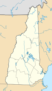
| Location in New Hampshire | ||
|
|
||
| Basic data | ||
| Foundation : | 1784 | |
| State : | United States | |
| State : | New Hampshire | |
| County : | Grafton County | |
| Coordinates : | 44 ° 21 ′ N , 71 ° 48 ′ W | |
| Time zone : | Eastern ( UTC − 5 / −4 ) | |
| Residents : | 5,928 (as of 2010) | |
| Population density : | 45.7 inhabitants per km 2 | |
| Area : | 140.1 km 2 (approx. 54 mi 2 ) of which 129.8 km 2 (approx. 50 mi 2 ) is land |
|
| Height : | 334 m | |
| Postal code : | 03561 | |
| Area code : | +1 603 | |
| FIPS : | 33-42580 | |
| GNIS ID : | 0873649 | |
| Website : | www.TownOfLittleton.org | |
Littleton is a small town in New Hampshire in the United States . The city is located in Grafton County on the edge of the White Mountains .
Demographics
At the time of the 2000 census ( US Census 2000 ) the city had 5,845 inhabitants on a land area of 129.8 km². The mean age was 39.2 years (US national mean: 35.3 years). The per capita income (Engl. The per capita income ) was (national average of USA: 21,587 US dollars) for 18,803 US dollars. 11.4% of the population had their income below the poverty line (US national average: 12.4%). About 19.0% of Littletown's residents are of English descent and about 7.5% are of German descent .
Personalities
sons and daughters of the town
- George H. Amidon (1904–1976), politician
- Wayne Green (1922-2013), publicist
- Eleanor Hodgman Porter (1868–1920), children's author
Web links
- official website of the city of Littleton (English)
- Statistics about Littletown at city-data.com (English)
