Grafton, New Hampshire
| Grafton | ||
|---|---|---|
|
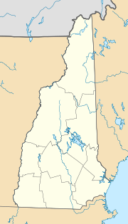
Location in New Hampshire
|
||
| Basic data | ||
| Foundation : | November 11, 1778 | |
| State : | United States | |
| State : | New Hampshire | |
| County : | Grafton County | |
| Coordinates : | 43 ° 35 ′ N , 71 ° 58 ′ W | |
| Time zone : | Eastern ( UTC − 5 / −4 ) | |
| Residents : | 1,613 (as of 2010) | |
| Population density : | 14.9 inhabitants per km 2 | |
| Area : | 110.4 km 2 (approx. 43 mi 2 ) of which 107.9 km 2 (approx. 42 mi 2 ) is land |
|
| Height : | 286 m | |
| Postal code : | 03240 | |
| Area code : | +1 603 | |
| FIPS : | 33-30820 | |
| GNIS ID : | 00873609 | |
| Website : | www.TownOfGrafton.com | |
Grafton is a parish in New Hampshire , United States . It had 1613 inhabitants at the 2010 census. Grafton is located on a plateau of the Green Mountains , the so-called Upper Valley .
history
The parish is named after Augustus FitzRoy, 3rd Duke of Grafton , like the county of the same name in which it is located .
The village was founded in 1778 as a municipality in the sense of a state regional body . It was settled before.
politics
The community of Graftown is self-governed directly by its citizens . In preadvisory community meetings ( "town meetings") are worked out proposals for resolutions, which in the context of public decisions to accept or reject. The elected “ Board of selectmen ” implements the citizens' resolutions and supervises the municipal administration .
Grafton is considered one of the strongholds of the Free State Project .
Individual evidence
- ↑ http://freekeene.com/2013/02/14/free-staters-prevent-further-increases-make-cuts-in-budgets-in-keene-and-grafton/
