Loquard
|
Loquard
Krummhörn municipality
|
|
|---|---|
| Coordinates: 53 ° 23 '25 " N , 7 ° 2' 44" E | |
| Height : | 4 m |
| Area : | 10.17 km² |
| Residents : | 614 (December 31, 2012) |
| Population density : | 60 inhabitants / km² |
| Incorporation : | July 1, 1972 |
| Postal code : | 26736 |
| Area code : | 04927 |
|
Card of the Krummhörn
|
|
Loquard is a village in the municipality of Krummhörn in the Aurich district in East Frisia . 614 inhabitants live in the place (as of December 31, 2012).
history
1744 Loquard fell (originally Lach worth / Laccuurdh : lake or marsh island) as the whole of East Frisia on Prussia . In 1756 the Prussian officials compiled a statistical trade survey for East Friesland. That year there were 35 merchants and craftsmen in Loquard, more than in most of the Krummhorn villages - with the exception of Greetsiel and Pilsum. This was mainly due to the relatively high number of line weavers, namely ten. In addition, there were four tailors and carpenters each, three bakers, three bricklayers and shoemakers, two blacksmiths and one cooper and wheel maker each. Of the four merchants, one traded in tea, coffee, sugar, spices and sheets as well as other woolen goods, the other three were referred to as Höker, i.e. petty merchants.
During the Hanoverian period in East Friesland, Loquard belonged to the Amt Emden (1824), therein to the Bailiwick of Larrelt and in turn to the Lower Bailiwick Loquard, which in addition to the seat of the Lower Bailiwick also included Woltzeten, Rysum, Campen, Heiselhusen and Canum.
For centuries, the natural depths and drainage channels that crisscross the Krummhörn in a dense network were the most important modes of transport. Not only the villages but also many farms were connected to the city of Emden and the port of Greetsiel via ditches and canals. The boat traffic with Emden was particularly important. Village boatmen took over the supply of goods from the city and delivered agricultural products in the opposite direction: “From the Sielhafenort, smaller ships, so-called Loogschiffe, transported the cargo to the inland and supplied the marsh villages (loog = village). The Loogschiffe from the Krummhörn enlivened the canals of the city of Emden into the 20th century. ”As early as 1824, the cultural historian Fridrich Arends wrote in his description of the land of the Principality of East Friesland and the Harlingerland :“ There is no office more abundant than this with water. (...) In winter and spring, the transport of grain and other goods done both in this than in Greetmer Office always water, which has in the bad Klei paths in the season extraordinary benefits. "Loquard was over the Loquarder depth and Larrelter depth with the seaport town of Emden and is still so today, although the Knockster Tief , which was expanded in the far half of the 19th century, has been a connection between the first two since that time.
Peat, which was mostly extracted in the East Frisian Fehnen , played an important role as heating material for the inhabitants of the Krummhörn for centuries . The peat ships brought the material along the East Frisian canal network to the Krummhörn villages, including Loquard. On their way back into the Fehnsiedlungen the Torfschiffer often took clay soil from the march and the manure of cattle with which they their home were dug fertilized land.
In April 1919 there were so-called "bacon removals" from Emden workers, which were followed by rioting on the farm workers. Together with the Rheiderland , the district of Emden was the part of East Frisia most affected by this unrest. Workers broke into the surrounding villages in closed trains and stole food from farmers in clashes. The situation only calmed down after the deployment of the Reichswehr troops stationed in the region . As a reaction to this, resident groups were formed in almost all villages in the Emden area . The Loquard Rescue Service comprised 38 people. These had 25 weapons. The resident services were only dissolved after a corresponding decree by the Prussian Interior Minister Carl Severing on April 10, 1920.
On July 1, 1972 Loquard was incorporated into the new municipality of Krummhörn.
Culture and sights
Buildings
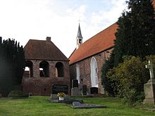
One of the sights of the place is the single-nave, brick church . It was built in the 13th century and is 34 meters long. In the interior there is a precious carved altar depicting the Passion of Christ. It is a Flemish carving that was made around 1520.
In the Middle Ages, there was a castle next to the church, where the chiefs lived. The castle was destroyed by order in the 15th century at the end of the pirate era. Only the ring-shaped moat has been preserved, which can be reached via a wooden bridge, and inside today there is a small garden in which the outlines of the old castle are reproduced by roses.
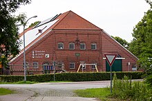
The Loquard primary school was set up in an old listed Gulfhof . Occasional events by the Krummhörn Rural Academy take place here, and the school is used for exhibitions during the school holidays.
Sports
The local sports club is FC Schwarz-Weiß Loquard. It was founded in 1928 as the football club Alemannia Schwarz-Weiß Loquard and remained one until the inauguration of the sports hall in Loquard in 1981. Since then, indoor sports have also been offered, including a table tennis division. As of the 2013/2014 season, the first men's soccer team will play in the East Friesland- wide district league ( Ostfrieslandliga ), the third-lowest (or eighth-highest) division in the league system in Lower Saxony.
Web links
Individual evidence
- ^ Johann Jakob Egli : Nomina geographica. Language and factual explanation of 42,000 geographical names of all regions of the world. 2nd Edition. Friedrich Brandstetter, Leipzig 1893, p. 518 ( Laach )
- ↑ Karl Heinrich Kaufhold , Uwe Wallbaum (ed.): Historical statistics of the Prussian province of East Friesland ( sources for the history of East Friesia , volume 16). Verlag Ostfriesische Landschaft, Aurich 1998, ISBN 3-932206-08-8 , p. 383.
- ^ Curt Heinrich Conrad Friedrich Jansen: Statistical Handbook of the Kingdom of Hanover 1824 . P. 161, Textarchiv - Internet Archive .
- ^ Harm Wiemann, Johannes Engelmann: Old streets and ways in East Friesland . Self-published, Pewsum 1974, p. 169 (East Frisia in the protection of the dyke; 8)
- ↑ Fridrich Arends: Erdbeschreibung des Fürstenthums Ostfriesland and Harlingerland , Emden 1824, p. 279 ff., Textarchiv - Internet Archive .
- ^ Gunther Hummerich: The peat shipping of the Fehntjer in Emden and the Krummhörn in the 19th and 20th centuries. In: Emder Yearbook for Historical Regional Studies in Ostfriesland , Volume 88/89 (2008/2009), pp. 142–173, here p. 163.
- ↑ Hans Bernhard Eden: The Resident Services of East Frisia from 1919 to 1921 . In: Emder Yearbook for Historical Regional Studies Ostfriesland , Volume 65, 1985, pp. 81–134, here pp. 94, 98, 105, 114.
- ^ Federal Statistical Office (ed.): Historical municipality directory for the Federal Republic of Germany. Name, border and key number changes in municipalities, counties and administrative districts from May 27, 1970 to December 31, 1982 . W. Kohlhammer, Stuttgart / Mainz 1983, ISBN 3-17-003263-1 , p. 263 f .
- ↑ Chronicle ( memento of June 9, 2014 in the Internet Archive ), accessed on June 2, 2013.
- ↑ Jörg-Volker Kahle: The bear's fur is almost spread . In: Emder Zeitung , June 1, 2013, p. 27.


