Rysum
|
Rysum
Krummhörn municipality
|
|
|---|---|
| Coordinates: 53 ° 22 ′ 45 ″ N , 7 ° 2 ′ 7 ″ E | |
| Height : | 4 (0.0-6.0) m |
| Area : | 10.06 km² |
| Residents : | 689 (Dec. 31, 2012) |
| Population density : | 68 inhabitants / km² |
| Incorporation : | July 1, 1972 |
| Postal code : | 26736 |
| Area code : | 04927 |
|
Map of the Krummhörn with Rysum as the southernmost village
|
|
Rysum is a "classic" Rundwarftendorf eleven kilometers west of Emden in East Frisia . The place is part of the municipality of Krummhörn with 18 other villages , on December 31, 2012 it had 689 inhabitants. Around the year 1000 the place was called Hrisinghem.
geography
Rysum is the southernmost village in the municipality of Krummhörn and the southwesternmost in the district of Aurich . It is located about eleven kilometers west of the city center of Emden. In the south and east the Rysum district borders the Emden district Wybelsum , part of the border is the Knockster Tief . In the north lies the Krummhörner neighboring village Loquard . To the west of Rysum is the Outer Ems . The Rysum district is protected from the Outer Ems and the North Sea by the sea dike , which is maintained by the Krummhörn dike . In front of the dike there is dike foreland for additional protection against storm surges. The Rysumer Tief , which was once connected to the Knockster Tief, runs east from Rysum . In a south-easterly direction, the Alte Tief flows towards the Knockster Tief. The water from the Old Deep is pumped into the Knockster Deep by a pumping station. Thus Rysum is the only one of the 19 Krummhorn villages that has no direct navigable connection (anymore) to the canal and waterway network northwest of Emden.
Rysum is worth seeing because of its design as a terp village , that is, it is located on an artificially created hill. The village yard is six meters above sea level and has a diameter of almost 400 meters. This “hill” served as the only effective flood protection long before the dyke was built. The so-called Zingel, a diked meadow area that borders the terp, also bears witness to this time. In the past, animals were driven into it during floods to protect them from the floods.
history
Rysum was one of the ten old so-called glories of East Frisia; their owners were directly subordinate to the prince and had lower jurisdiction. The place was first mentioned in the Werden arable land in the 10th century as Hrisinghem . The name is probably composed of the nickname Hriso, the collective suffix -ing and the ending -hem for home. As in many other places in East Frisia, the ending later became -um , but the unstressed middle syllable disappeared. The village was first referred to as Risum in 1355 and in today's spelling for the first time in 1438.
The Christmas flood of 1717 hit Rysum hard. According to a contemporary survey by the preacher Jacobus Isebrandi Harkenroth, 13 people were killed. Four horses, five cattle and 39 sheep drowned; three houses were completely destroyed and 17 partially.
With East Frisia , the glory of Rysum came to Prussia in 1744 . Prussian statistics from 1805/06 show that in those years there were 30 residents of whole squares , 15 residents of half squares and eight residents of a quarter square, i.e. smaller courtyards. There were also five warf people, kotters and house people. There was a steward of the noble estate, a preacher and two sextons . in those years nine Jews had their residence in Rysum. The population of Glory was 679, roughly the same as at the beginning of the 21st century. A diversified commercial life was added to the agriculture in the marsh village, which in addition to the farmers mentioned also included 20 field workers, carters and a shepherd. There were six carpenters and tailors, four shoemakers, three blacksmiths and bakers, two bricklayers, brewers and linen weavers as well as one lime burner, wheel maker, cooper and brandy burner each. Four shopkeepers, six boatmen and two innkeepers worked in the trade. A Bader and Feldscher and two midwives were responsible for medical care . 68 people also earned their living as day laborers. In agriculture there were 300 head of cattle (including 14 oxen and 76 head of young cattle), 418 sheep and 170 horses. So while sheep farming was one of the main focuses, pig breeding played no role at all in Rysum at the time. In arable farming, farmers concentrated on oats and especially rapeseed, but also grew wheat, rye, barley, potatoes, peas and beans to a lesser extent.
For centuries, the natural depths and drainage channels that crisscross the Krummhörn in a dense network were the most important modes of transport. Not only the villages but also many farms were connected to the city of Emden and the port of Greetsiel via ditches and canals. The boat traffic with Emden was particularly important. Village boatmen took over the supply of goods from the city and delivered agricultural products in the opposite direction: “From the Sielhafenort, smaller ships, so-called Loogschiffe, transported the cargo to the inland and supplied the marsh villages (loog = village). The Loogschiffe from the Krummhörn enlivened the canals of the city of Emden into the 20th century. ”As early as 1824, the cultural historian Fridrich Arends wrote in his description of the land of the Principality of East Friesland and the Harlingerland :“ There is no office more abundant than this with water. (...) In winter and spring, the grain and other goods are always transported by water, both in this office and in the Greetmer office, which is extremely useful in the case of the poor Kleiwege in the season. "Peat, which was mostly obtained in the East Frisian region , played an important role as heating material for the inhabitants of the Krummhörn for centuries . The peat ships brought the material on the East Frisian canal network to the Krummhörn villages, including to Rysum. On their way back into the Fehnsiedlungen the Torfschiffer often took clay soil from the march and the manure of cattle with which they their home were dug fertilized land.
During the Hanoverian time of East Frisia (1815–1866) the glory of Rysum was affiliated with the Emden office, as Rysum did not have its own patrimonial court . Rysum belonged to the Amt Emden (1824), in it to the Bailiwick of Larrelt and in turn to the Lower Bailiwick Loquard, which in addition to Loquard and Rysum also included Campen, Heiselhusen, Woltzeten and Canum. The legal succession of the former glory is now in the family v. Quistorp .
On July 1, 1972, Rysum was incorporated into the new municipality of Krummhörn.
politics
coat of arms
The coat of arms in the colors silver and blue is divided in a wave cut. It shows a growing black eagle at the top and a silver three-leaf clover at the bottom. The eagle comes from the coat of arms of the chiefs of Loquard and refers to the togetherness of the glories Loquard and Rysum, which lasted until 1484. The colors silver and blue in the lower half of the shield are reminiscent of the rule of the noble Frese family .
Culture and sights
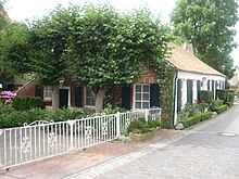
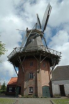
In the Rysumer Church , which was built as the center of the village at the highest point of the terp, is the oldest still playable organ in northern Europe from around 1440. It is worth mentioning the Rysumer mill from 1895 , which is located in the immediate vicinity of the church The center of the village also has a large number of older Gulf farms and farm workers' houses , the oldest of which dates from 1766 and is the oldest residential building in the village (and the second oldest building after the church).
Economy and Infrastructure
The main road through Rysum is Landesstraße 2 from Neermoor via Emden and Rysum to Pewsum . It leads north past the historic town center. Between Rysum and Wybelsum there is only a cycle path along the state road on the Emden section, the gap to Rysum has not yet been closed. The public transport is by the line 422 of the web owned subsidiary Weser-Ems-Bus operated, connects the Emden about Rysum with Pewsum. It runs almost every hour from Monday to Friday, less on the weekend. Rysum does not have its own school. The elementary school is - like the nearest kindergarten - in the neighboring village of Loquard, secondary schools in Pewsum and Emden.
Personalities
- Karl Eduard Immer (1916–1984), President of the Evangelical Church in the Rhineland, was born on May 28, 1916 in Rysum.
literature
- Heinrich Schmidt : Political history of East Frisia ( East Frisia in the protection of the dike , Volume 5). Rautenberg publishing house, Leer 1975.
Web links
- Homepage of the Warfendorf Rysum
- Homepage of the interest group Rysum e. V.
- Official homepage of the municipality of Krummhörn
- Achim von Quistorp: Rysum - a portrait of the former glory . (PDF; 1.1 MB) Hamburg 2012
Individual evidence
- ↑ Arend Remmers : From Aaltukerei to Zwischenmooren - The settlement names between Dollart and Jade . Verlag Schuster, Leer 2004, ISBN 3-7963-0359-5 , p. 191.
- ↑ Quoted in: Ernst Siebert: Development of the dyke system from the Middle Ages to the present (= Ostfriesland in the protection of the dike. Volume 2). Verlag Deichacht Krummhörn, Pewsum 1969, p. 334 f.
- ^ Karl Heinrich Kaufhold; Uwe Wallbaum (Ed.): Historical statistics of the Prussian province of East Friesland (= sources for the history of East Friesland. Volume 16), Verlag Ostfriesische Landschaft, Aurich 1998, ISBN 3-932206-08-8 , pp. 136, 144, 374, 593 and 619.
- ^ Harm Wiemann, Johannes Engelmann: Old streets and ways in East Friesland . Self-published, Pewsum 1974, p. 169 ( East Frisia in the protection of the dyke , 8)
- ↑ Fridrich Arends: Earth description of the principality of East Friesland and the Harlingerland . Emden 1824, p. 279 ff., Textarchiv - Internet Archive .
- ^ Gunther Hummerich: The peat shipping of the Fehntjer in Emden and the Krummhörn in the 19th and 20th centuries. In: Emder Yearbook for Historical Regional Studies in Ostfriesland , Volume 88/89 (2008/2009), pp. 142–173, here p. 163.
- ↑ Fridrich Arends: Earth description of the principality of East Friesland and the Harlingerland. Emden 1824, p. 278; Text archive - Internet Archive . In the following Arends: Earth description .
- ^ Curt Heinrich Conrad Friedrich Jansen: Statistical Handbook of the Kingdom of Hanover 1824 . P. 166; Text archive - Internet Archive .
- ↑ For the succession see: Achim von Quistorp: Rysum - a portrait of the former glory. Hamburg 2012 (PDF).
- ^ Federal Statistical Office (ed.): Historical municipality directory for the Federal Republic of Germany. Name, border and key number changes in municipalities, counties and administrative districts from May 27, 1970 to December 31, 1982 . W. Kohlhammer, Stuttgart / Mainz 1983, ISBN 3-17-003263-1 , p. 263 f .
- ^ Karl Leiner: Panorama district north. Images - coats of arms - people - notes . Norden 1972. p. 377
- ↑ Rysumer Mill . Mühlenstrasse working group id Mühlenvereinigung Niedersachsen - Bremen eV Accessed June 27, 2012.
- ^ Alfred Meiborg: Closing the gap can take years. In: Ostfriesen-Zeitung , April 25, 2009, accessed on December 20, 2018.
- ↑ Timetable line 422 (PDF) weser-ems-bus.de, 4 pages; accessed on December 20, 2018.


