
Camping (Krummhörn)
|
Camp
Krummhörn municipality
|
|
|---|---|
 |
|
| Height : | 1 (0-1) m |
| Area : | 6.06 km² |
| Residents : | 474 (Dec. 31, 2012) |
| Population density : | 78 inhabitants / km² |
| Incorporation : | July 1, 1972 |
| Postal code : | 26736 |
| Area code : | 04927 |
 Card of the Krummhörn
|
|
Camping is a village in the municipality of Krummhörn in the Aurich district in East Frisia . The population is 536 (as of December 31, 2006).
geography
Camping is a clustered settlement . It is located about twelve kilometers northwest of Emden. The place was created in a limestone marshland at a height between 0.3 and 0.6 m above sea level. NHN . In total, the district covers an area of 6.06 square kilometers.
history
Camping is first mentioned in the 10th century as in Campe maiori . In the 10th and 11th centuries the name was common in Campun . Later name variants were in maiori Compum (1395) and Kampen (1424). The place name is the dative plural of the old Frisian term kamp or komp (= field). It therefore means (in the) fields . Coin finds prove that camping was already settled in the early Middle Ages. In the 13th century, the residents of the village built a church on the highest point of the terp.
In 1744 camping fell to Prussia like all of East Friesland . In 1756 the Prussian officials compiled a statistical trade survey for East Friesland. In that year there were 15 merchants and craftsmen in Campen, which meant that camping remained in the shadow of the neighboring village of Loquard, which was much more heavily occupied with craftsmen and merchants. In Campen there were four tailors, two blacksmiths, two shoemakers and linen weavers as well as one cooper, baker, bricklayer and carpenter. The only local merchant traded in soap, spices, sugar and tea.
Campen and Heiselhusen were part of the Emden district during the Hanoverian period in East Friesland (1824), part of the Larrelt bailiwick and then part of the Loquard sub-bailiwick, which in addition to Loquard, Campen and Heiselhusen also included Rysum and Canum.
For centuries, the natural depths and drainage channels that crisscross the Krummhörn in a dense network were the most important modes of transport. Not only the villages but also many farms were connected to the city of Emden and the port of Greetsiel via ditches and canals. The boat traffic with Emden was particularly important. Village boatmen took over the supply of goods from the city and delivered agricultural products in the opposite direction: “From the Sielhafenort, smaller ships, so-called Loog ships, transported the cargo to the inland and supplied the marsh villages (loog = village). The Loogschiffe from the Krummhörn enlivened the canals of the city of Emden into the 20th century. ”As early as 1824, the cultural historian Fridrich Arends wrote in his description of the land of the Principality of East Friesland and the Harlingerland :“ There is no office more abundant than this with water. (…) In winter and spring, the grain and other goods are always transported by water both in this and in the Greetmer office, which is extremely useful in the case of the poor dirt roads in the season. "
Peat, which was mostly extracted in the East Frisian Fehnen , played an important role as heating material for the inhabitants of the Krummhörn for centuries . The peat ships brought the material on the East Frisian canal network to the villages of the Krummhörn, including to Camping. On their way back into the Fehnsiedlungen the Torfschiffer often took clay soil from the march and the manure of cattle with which they their home were dug fertilized land.
After the end of the Second World War, camping took in a large number of displaced persons from the eastern regions of the German Reich . In 1946 they made up 23.1 percent of the village population, a quota that remained constant until 1950. On July 1, 1972, camping was incorporated into the new municipality of Krummhörn.
politics
The head of the village is Marion Niebergall.
Culture and sights
Germany's highest lighthouse is located in Campen at 65.3 m . It was built in 1889 and has been in operation since 1891. The lighthouse can be visited by climbing 320 steps. When the visibility is good, the view extends to the East Frisian Islands over the Netherlands to the city of Emden.
Another attraction is the East Frisian Agricultural Museum, which is housed in two Gulf farms . Old agricultural equipment from the 1930s to 1950s is on display there. In addition, special events take place in the summer months.
The Reformed Church , which was built in the 13th century, is worth seeing . The old reformed church dates from 1905.

Lighthouse and dike
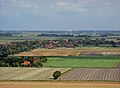
View over camping

Old Reformed Church Camping

Reformed Church camping


traffic
The place is connected to the city of Emden via Landesstraße 2 , where there is a connection to the A31 .
The public transport is ensured by the daily circulating line 422 of DB Weser-Ems-Bus.
literature
- Hensman Dreesman: Description of the community Campen (manuscript 1888; edited and provided with explanations by Heinrich Schumacher). East Frisian Landscape, Aurich 1990, ISBN 3-925365-53-2 .
- Jannes Ohling: Camping. Chronicle of a village in Krummhörn / East Friesland. Self-published by the publisher, Campen 1970.
Web links
- Official website of the municipality of Krummhörn with information on the sights
Individual evidence
- ↑ a b c local chronicles of the East Frisian landscape : Camping, municipality Krummhörn, district Aurich . (PDF; 987 kB), accessed on April 18, 2013.
- ^ Karl Heinrich Kaufhold ; Uwe Wallbaum (Ed.): Historical statistics of the Prussian province of East Friesland (sources on the history of East Friesland, Volume 16), Verlag Ostfriesische Landschaft, Aurich 1998, ISBN 3-932206-08-8 , p. 383.
- ^ Friedrich Jansen : Statistical Manual of the Kingdom of Hanover 1824. P. 110, Textarchiv - Internet Archive .
- ^ Harm Wiemann / Johannes Engelmann: Old streets and ways in East Frisia . Self-published, Pewsum 1974, p. 169 (East Frisia in the protection of the dyke; 8)
- ↑ Fridrich Arends: Earth description of the principality of East Friesland and the Harlingerland . Emden 1824, p. 279 ff., Archive.org .
- ^ Gunther Hummerich: The peat shipping of the Fehntjer in Emden and the Krummhörn in the 19th and 20th centuries. In: Emder Yearbook for Historical Regional Studies in Ostfriesland , Volume 88/89 (2008/2009), pp. 142–173, here p. 163.
- ^ Federal Statistical Office (ed.): Historical municipality directory for the Federal Republic of Germany. Name, border and key number changes in municipalities, counties and administrative districts from May 27, 1970 to December 31, 1982 . W. Kohlhammer, Stuttgart / Mainz 1983, ISBN 3-17-003263-1 , p. 263 f .
- ↑ localities . ( Memento of the original from August 4, 2017 in the Internet Archive ) Info: The archive link was inserted automatically and has not yet been checked. Please check the original and archive link according to the instructions and then remove this notice. Krummhörn municipality
