
Loubaresse (Cantal)
| Loubaresse | ||
|---|---|---|
|
||
| local community | Val d'Arcomie | |
| region | Auvergne-Rhône-Alpes | |
| Department | Cantal | |
| Arrondissement | Saint-Flour | |
| Coordinates | 44 ° 56 ' N , 3 ° 13' E | |
| Post Code | 15320 | |
| Former INSEE code | 15108 | |

Loubaresse is a village in the Margeride in the French Massif Central . It was an independent municipality until January 1, 2016 and belonged to the Auvergne-Rhône-Alpes region , the Cantal department , the Saint-Flour arrondissement and the Neuvéglise canton . It was incorporated into the Commune nouvelle Val d'Arcomie by decree of September 30, 2015 . Since then it has been a commune déléguée and the capital of the new municipality. Neighboring towns are Anglards-de-Saint-Flour in the northwest, Ruynes-en-Margeride in the north, Chaliers in the northeast, Chaulhac in the east, Albaret-Sainte-Marie in the southeast, Saint-Just in the south, Saint-Marc in the southwest and Faverolles in the West.
Population development
| year | 1962 | 1968 | 1975 | 1982 | 1990 | 1999 | 2008 | 2013 |
|---|---|---|---|---|---|---|---|---|
| Residents | 628 | 624 | 543 | 443 | 418 | 434 | 409 | 402 |
Attractions
- Church in the Bournoncles quarter
- War Memorial in Bournoncles
- Ferme Allègre, Monument historique
- Ferme Torrette, Monument historique
- Garabit Railway Viaduct , built under the direction of Gustave Eiffel , Monument historique, is about 10 km away
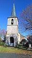
Bournoncles Church
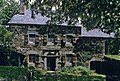
Ferme Allègre
Ferme Torrett

Garabit station on the Béziers – Neussargues line

Loubaresse station

Garabit Railway Viaduct


