
Lovas
| Lovas | |||||
|
|||||
| Basic data | |||||
|---|---|---|---|---|---|
| State : | Hungary | ||||
| Region : | Central Transdanubia | ||||
| County : | Veszprém | ||||
| Small area until December 31, 2012 : | Balatonfüred | ||||
| District since 1.1.2013 : | Balatonfüred | ||||
| Coordinates : | 47 ° 0 ′ N , 17 ° 58 ′ E | ||||
| Area : | 5.95 km² | ||||
| Residents : | 432 (Jan. 1, 2011) | ||||
| Population density : | 73 inhabitants per km² | ||||
| Telephone code : | (+36) 87 | ||||
| Postal code : | 8228 | ||||
| KSH kódja: | 05564 | ||||
| Structure and administration (as of 2020) | |||||
| Community type : | local community | ||||
| Mayoress : | Gáborné Ferenczy (independent) | ||||
| Postal address : | Fő u. 8 8228 Lovas |
||||
| Website : | |||||
| (Source: A Magyar Köztársaság helységnévkönyve 2011. január 1st at Központi statisztikai hivatal ) | |||||


Lovas is a Hungarian municipality in the Balatonfüred district in Veszprém county .
Geographical location
Lovas is a good ten kilometers south of the town of Veszprém on the eastern part of Lake Balaton on the small Lovasi-Séd river . The place is one kilometer from the northern shore of Lake Balaton. Neighboring communities are Alsóörs, Paloznak and Felsőörs .
Parish partnership
Attractions
- Gyula Nagy Gallery ( Nagy Gyula Galéria )
- Reformed Church, built in 1910
- Roman Catholic Church Szűz Mária neve , originally from the time of Árpád , rebuilt in the 18th century (Baroque)
- Traditional farmhouses (in Malomvölgyi utca)
- Watermill ( Vízimalom )
traffic
In Lovas, roads no. 7219 and no. 7221 meet. South of the village, the main road No. 71 runs along the shore of Lake Balaton. The nearest train station is in Alsóörs and is connected to the railway line from Székesfehérvár to Tapolca .
photos

Center with both churches

Entrance of the Roman Catholic. church

Traditional farmhouse

Old watermill
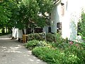
Garden of the watermill

Kopjafa near the Lovasi-Séd


Web links
- Official website ( Hungarian )
- Lovas at Magyarország helységnévtára (Hungarian)