Balatonfüred district
| circle Balatonfüredi járás
Balatonfüred |
|
|---|---|
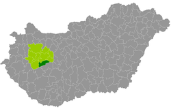
 Location of the district in Hungary |
|
| Basic data | |
| Country | Hungary |
| County | Veszprém |
| Seat | Balatonfüred |
| surface | 357.8 km² |
| Residents | 24,058 (January 1, 2016) |
| density | 67 inhabitants per km² |
The Balatonfüred district ( Hungarian Balatonfüredi járás ) is a district in the south of the Hungarian Veszprém county . It is bordered to the west by the district Tapolca , north to the county Veszprém , on the east by the county Balatonalmádi . In the south, the border with Somogy County runs over Lake Balaton ( Hungarian: Balaton ).
history
In the course of the Hungarian administrative reform at the beginning of 2013, all municipalities from the small area of the same name (Hungarian Balatonfüredi kistérség ) moved to the successor circle of the same name. In addition, there was a community from the small area of Balatonalmádi to the east . 11 of the 22 municipalities have access to Lake Balaton.
Community overview
The Balatonfüred district has an average community size of 1,094 inhabitants on an area of 16.26 square kilometers. The population density of the district is slightly below the county value of 77 inhabitants / km². The district seat is in the only town, Balatonfüred .
| Communities | status | Origin small area |
population | Area (km²) | Population density (inh / km²) |
||
|---|---|---|---|---|---|---|---|
| October 01, 2011 | 01/01/2013 | 01/01/2016 | |||||
| Alsóörs | local community | Balatonalmádi | 1,541 | 1,586 | 1,653 | 33.34 | 49.6 |
| Aszófő | local community | Balatonfüred | 400 | 392 | 395 | 8.32 | 47.5 |
| Balatonakali | local community | Balatonfüred | 658 | 644 | 624 | 36.20 | 17.2 |
| Balatoncsicsó | local community | Balatonfüred | 207 | 214 | 223 | 13.20 | 16.9 |
| Balatonfüred | city | Balatonfüred | 12,979 | 13,313 | 13,082 | 46.45 | 281.6 |
| Balatonszepezd | local community | Balatonfüred | 341 | 393 | 377 | 25.06 | 15.0 |
| Balatonszőlős | local community | Balatonfüred | 640 | 625 | 634 | 12.81 | 49.5 |
| Balatonudvari | local community | Balatonfüred | 292 | 310 | 301 | 18.80 | 16.0 |
| Csopak | local community | Balatonfüred | 1,715 | 1,741 | 1,742 | 23.98 | 72.6 |
| Dörgicse | local community | Balatonfüred | 248 | 254 | 250 | 19.12 | 13.1 |
| Lovas | local community | Balatonfüred | 419 | 428 | 456 | 5.95 | 76.6 |
| Monoszló | local community | Balatonfüred | 100 | 120 | 106 | 7.46 | 14.2 |
| Óbudavár | local community | Balatonfüred | 49 | 53 | 52 | 3.23 | 16.1 |
| Örvényes | local community | Balatonfüred | 154 | 158 | 127 | 4.46 | 28.5 |
| Paloznak | local community | Balatonfüred | 423 | 441 | 423 | 8.80 | 48.1 |
| Pécsely | local community | Balatonfüred | 509 | 526 | 549 | 20.01 | 27.4 |
| Szentantalfa | local community | Balatonfüred | 409 | 433 | 443 | 6.61 | 67.0 |
| Szentjakabfa | local community | Balatonfüred | 110 | 109 | 110 | 5.76 | 19.1 |
| Tagyon | local community | Balatonfüred | 87 | 84 | 88 | 2.76 | 31.9 |
| Tihany | local community | Balatonfüred | 1,368 | 1,358 | 1,383 | 27.33 | 50.6 |
| Vászoly | local community | Balatonfüred | 236 | 247 | 243 | 8.55 | 28.4 |
| Zánka | local community | Balatonfüred | 964 | 821 | 797 | 19.55 | 40.8 |
| Balatonfüred district | 23,849 | 24,250 | 24,058 | 357.75 | 67.2 | ||
swell
PDF and XLS files: 2011
Census :
2013:; 2016:
Individual evidence
- ↑ KSH: 2011. Évi Népszámlálás. In: 3. Területi adatok. KSH, accessed on December 30, 2016 (Hungarian, also via: http://www.terezvaros.hu/testuleti/nepsz2011-3/pdf/nepsz2011_03_19.pdf ).
- ↑ KSH: Regional data - Veszprém county. KSH, accessed December 30, 2016 (English, 4th Data on Localities).
- ↑ KSH: Gazetteer of Hungary, 1st January, 2013. KSH, accessed April 7, 2017 (Hungarian / English).
- ↑ KSH: Gazetteer of Hungary, 1st January, 2016. KSH, accessed April 7, 2017 (Hungarian / English).