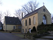
Luisenfriedhof II


The Evangelical Luisenfriedhof II (also called Westend-Friedhof ) is located at Königin-Elisabeth-Straße 46 in Berlin-Westend . The side entrance is located diagonally across from the main entrance on Lerschpfad and adjacent to the Westend S-Bahn station . This avenue district cemetery has an area of 47,710 m².
history
When the first cholera epidemic reached Charlottenburg in August 1831 , some of the residents who died of the disease were buried in the sand pits on the Spandauer Berg outside the city gates . At the end of the 1850s it was decided to convert the epidemic cemetery into a regular cemetery. When cholera broke out again in Charlottenburg in 1866, the decision was implemented. The cemetery was landscaped with avenues crossing at right angles. The inauguration of the cemetery took place on May 27, 1867. In 1868 the cemetery chapel, which is now a listed building, was completed by Rudolf Zeitler . The cemetery was expanded several times in the following years, including a (former) private cemetery belonging to the family of the magazine publisher Ludwig von Schaeffer-Voit , which alone was 2500 square meters in size.
In June 1891 the Luisenfriedhof III in Fürstenbrunner Strasse was closed here. But as early as 1902, Cemetery II was reopened due to the strong population growth. Over time, a number of luxurious hereditary burials were erected in the cemetery, testifying to the growing prosperity of the citizens of Charlottenburg.
Around 1935, according to Albert Speer's plans for the design of Berlin as the world capital Germania, the cemetery was to lose land to the west and east. The Königin-Elisabeth-Straße and the neighboring railway systems were to be developed as rings around the city. In the era of National Socialism , there were no such measures. But in the post-war period the appearance of the cemetery was permanently disturbed by traffic structures. Queen Elisabeth Street was widened by 14 meters in the early 1960s at the expense of the cemetery. On the east side, the cemetery lost space for the construction of the Berlin city motorway . Numerous hereditary burial grounds were laid down for both measures.
The need for urn sites due to the increasing share of cremations and less effort for tending to graves requires new areas to be divided. In the cemetery there are many old grave sites with representative gravestones and also several bars. Nevertheless, there are signs that the grave sites have expired. Empty grave borders also bear witness to the change in the sepulchral culture. It should be noted that the hereditary burial marks have been removed from the southern cemetery wall. In front of it there are now several urn sites.
War graves with dead from both world wars are located in the outermost edge near the motorway. A small memorial stands with it, on top is a helmet, next to it are binoculars. Two laurel wreaths from the outside, whether there was an inscription could not be determined. 226 war dead rest here.
Graves of famous people
(* = Honor grave of the state of Berlin)
- Fernando Baare (1879–1952), Prussian major in the General Staff and German entrepreneur
- Wilhelm von Bode (1845–1929), art historian, general director of the Royal / State Museums
- Richard Boeckh (1824–1907), professor of statistics
- Hans Brausewetter (1899–1945), actor
- Gustav Eilers (1834–1911), engraver
- Adolph Frank (1834–1916) chemist and polymath
- Hans Fritsche * (1832–1898), Lord Mayor of Charlottenburg
- Karl Friedrich von der Goltz * (1815–1901), Prussian general of the cavalry
- Leopold Heinrich von der Goltz * (1746–1816), Prussian lieutenant general, chief of the body cuirassier regiment and diplomat
- Robert von der Goltz (diplomat) * (1817–1869), Prussian diplomat
- Hedwig Heyl (1850–1934), politician, women's rights activist, in a family mausoleum
- Julius Kohte (1861–1945), conservator and university professor
- Paul Samson Körner (1887–1942), champion boxer
- Max Kretzer (1854–1941), writer
- Gustav Kromrey , secessionist tomb by Gustav Goerke
- Rochus von Liliencron (1820–1912), co-editor of the Allgemeine Deutsche Biographie
- Otto March (1845–1913), architect
- Werner March (1894–1976), architect
- Adalbert Matkowsky (1857–1909), first "royal Prussian court actor"
- Willi Oesterlein * (1909–1992), city elder
- Carl Otto (1875–1916), sculptor
- Liselotte Richter * (1906–1968), philosopher, religious scholar, city councilor
- Gustav Roethe (1859–1926), Germanist
- Fritz Schaudinn (1871–1906), zoologist, co-discoverer of the syphilis pathogen
- Memorial stone for the Schaeffer-Voit family , (their private cemetery was demolished, some dimensions can still be seen)
- Alfred Schrobsdorff (1861–1940), real estate entrepreneur
- Rudolf Siemering (1835–1905), sculptor
- Adolf Slaby (1849–1913), physicist, founder of the Telefunken Society, with a large family
- Harry Walden (1875-1921), actor
- Paul Wittig (1853–1943), building officer, director of the elevated railway company
- Albert Wolff (1815-1892), sculptor
- Julius Wolff (1834–1910), poet and writer
- Antonie Zerwer (1873–1956), child nurse
The cemeteries of the Luisen community
- Luisenfriedhof I , since 1815, Guerickestrasse 5-9, Berlin-Charlottenburg
- Luisenfriedhof II, since 1867, Königin-Elisabeth-Strasse 46–50, Berlin-Westend
- Luisenfriedhof III , since 1891, Fürstenbrunner Weg 37–67, Berlin-Westend
literature
- Birgit Jochens, Herbert May: The cemeteries in Berlin-Charlottenburg / History of the cemetery facilities and their tomb culture . Stapp Verlag, Berlin 1994, ISBN 3-87776-056-2 .
- Hans-Jürgen Mende: Lexicon of Berlin tombs . Haude & Spenersche Verlagbuchhandlung, Berlin 2006, ISBN 3-7759-0476-X .
- Klaus Konrad Weber, Peter Güttler, Ditta Ahmadi (eds.): Berlin and its buildings. Part X Volume A: Facilities and structures for supply (3) Funeral services . Verlag von Wilhelm Ernst & Sohn, Berlin 1981, ISBN 3-433-00890-6 .
Web links
Individual evidence
- ↑ Entry in the Berlin State Monument List
- ↑ Cemetery development plan (PDF; 11.9 MB)
- ↑ http://www.denkfried.de/wp/?page_id=14089
Coordinates: 52 ° 30 ′ 56.5 ″ N , 13 ° 16 ′ 57.9 ″ E


