Styrum (Mülheim an der Ruhr)
|
Styrum district 3 of Mülheim an der Ruhr |
|
|---|---|
| location | |
| Basic data | |
| Area : | 4.44 km² |
| Residents : | 15,484 (December 31, 2014) |
| Population density : | 3,487 inhabitants per km² |
| Incorporated on: | April 1, 1904 |
|
District before incorporation: |
District of Mülheim an der Ruhr |
| Postal code : | 45476 |
| Area code : | 0208 |
| structure | |
| District : | Rechtsruhr-Nord |
| District number: | 3 |
| image | |
|
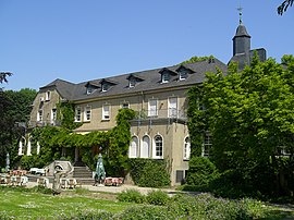
Styrum Castle |
|
Styrum [ ˈʃtiːʁʊm ] as a district of Mülheim an der Ruhr is located on the lower reaches of the Ruhr and was created on April 1, 1910 through the division of the centuries-old settlement of Styrum . The remaining part of the former settlement is now the Styrum district of Oberhausen . The Oberhausen district is also known as Unterstyrum, the Mülheim district as Oberstyrum.
location
Styrum is located in the Rechtsruhr-Nord district and borders on the equally divided district of Dümpten , Altstadt II , Speldorf and the Oberhausen districts of Alstaden and Styrum .
Styrum is about eight kilometers from where the Ruhr flows into the Rhine . The landscape is shaped by the Lower Rhine Plain , which stretches its southeasternmost foothills along the river to Mülheim city center.
population
In 1819 the entire old settlement of Styrum had 573 inhabitants. At the end of 2014 there were around 15,500 people living in Mülheim-Styrum.
history
The southern parts of today's Mülheim district belonged historically to the Styrum rule until 1806 and the northern parts to the Broich rule . The district was created on April 1, 1910 when the municipality of Styrum was divided into Mülheim and Oberhausen.
traffic
The district has a railway connection with the Mülheim (Ruhr) -Styrum train station , which is served by the S1 and S3 lines of the Rhine-Ruhr S-Bahn . Freight trains from the Mülheim plant are also assembled here by Vallourec & Mannesmann Tubes .
In public transport , the district is accessed by tram line 112 and bus lines 122, 128 and 129. The tram line 110, which used to run in Styrum, was discontinued on October 3, 2015, since then the bus line 128 has served the branch to Friesenstrasse and on to Oberhausen-Ruhrpark.
Attractions
The Castle Styrum is located in the Ruhr valley on the right bank of the river. The castle was the cradle of the Styrum rule and ancestral seat of the Counts of Limburg-Styrum .
The Aquarius Water Museum is located in a water tower that was closed in 1982 and is part of the Route of Industrial Culture. The listed tower was renovated as part of the "MüGa" state horticultural show and converted into a museum.
The Neickmannshof and other buildings that are classified as cultural monuments due to their structural or historical importance are included in the list of architectural monuments in Styrum (Mülheim an der Ruhr) .
The listed church of St. Mariae Rosenkranz is also worth seeing .
Sons and daughters of the district
- Helmut Schlitt (1934–2005), jazz trumpeter
- Helge Schneider (* 1955), entertainer
Trivia
“Styrum change!”, Derived from the announcement of the tram conductors on the connection between Oberhausen and Mülheim, was a household word in the area that was jokingly shouted to someone who thoughtlessly “staring” (or “bulling”) in order to get his attention to promote.
Individual evidence
Web links
Coordinates: 51 ° 27 ' N , 6 ° 51' E


