Madurai (District)
| Madurai District மதுரை மாவட்டம் |
|
|---|---|

|
|
| State | Tamil Nadu |
| Administrative headquarters : | Madurai |
| Area : | 3,710 km² |
| Residents : | 3,038,252 (2011) |
| Population density : | 819 inhabitants / km² |
| Website : | madurai.tn.nic.in |
The Madurai District ( Tamil : மதுரை மாவட்டம் ; formerly Madura ) is a district of the Indian state of Tamil Nadu . The administrative center is the eponymous Madurai , the third largest city in Tamil Nadu, which can look back on more than two thousand years of history. The Madurai district has an area of 3,710 square kilometers and around 3.0 million inhabitants (2011 census).
geography
The Madurai district is located in the southern interior of Tamil Nadu. Neighboring districts are Sivaganga in the east, Virudhunagar in the south, Theni in the west, Dindigul in the north and Tiruchirappalli in the northeast.
The area of the Madurai district is 3,710 square kilometers. The landscape in the district is characterized by plains and isolated mountains. The largest river in the district is the Vaigai that flows through Madurai .
In the Madurai district there is an alternately humid tropical climate . The annual mean temperature in Madurai is 28.8 ° C, the annual mean precipitation is 840 mm. Most of the rainfall occurs during the northeast monsoon in October and November. It also rains during the southwest monsoons in August and September.
history
The current district area is the heartland of the historical Pandya dynasty, which ruled one of the first early empires of South India from Madurai in the first centuries BC. The invasion of the Kalabhra in the 4th century AD ended the supremacy of the Pandya, who from then on were only vassals of other rulers. At the end of the 12th century, the Pandyas managed to regain their supremacy. In 1310 Malik Kafur , a general of Ala ud-Din Khaljis , commanded a campaign by the Sultanate from Delhi to South India, conquered Madurai and founded the Sultanate of Madurai . The Islamic rule over the area remained short-lived: In 1372 the sultanate was defeated by the Hindu kingdom of Vijayanagar , which subsequently rose to become the most powerful empire in South India.
The Vijayanagar rulers set up military governors ( nayaks ) in different parts of their empire , who went into business for themselves after the fall of the Vijayanagar empire in 1565. The nayaks of Madurai ruled from Madurai and later from Tiruchirappalli (Trichinopoly) over the southern parts of what is now Tamil Nadu. After the death of the greatest Nayak ruler Tirumalai Nayak (1623-1659), the rule of the Nayaks of Madurai visibly destabilized before it finally went under in 1736. During the 18th century Madurai was ruled by the Nawabs of Arcot and the Marathas before it finally came under British influence. In 1801 the Madurai area finally became a part of British India .
The British incorporated the area as the district of Madura (Madurai) in the province of Madras . The district originally comprised a much larger area of over 22,000 square kilometers, stretching from the Western Ghats on the border with Kerala to the coast of the Bay of Bengal . After Indian independence, he came under the States Reorganization Act 1956 to the newly formed state of Madras, which now included the Tamil-speaking areas and was renamed Tamil Nadu in 1969 . The area of the Madurai district gradually shrank through the establishment of new districts: As early as 1910, the Ramanathapuram (Ramnad) district had been formed from the southern parts of the Madurai district and parts of the Tirunelveli district . This also included the area of today's Sivaganga and Virudhunagar districts until 1985 . Also in 1985, the Dindigul District split from the Madurai District. Finally, in 1996, the remaining area of Madurai District was divided into Madurai and Theni Districts .
population

According to the 2011 Indian census, the Madurai district has 3,038,252 inhabitants. The population density of 819 inhabitants per square kilometer is well above the Tamil Nadu average (555 inhabitants per square kilometer). 61 percent of the district's residents live in cities. The degree of urbanization is also above average (the Tamil Nadu average is 48 percent). 14 percent of the district's residents are lower castes ( Scheduled Castes ). At 84 percent, the literacy rate is above the Tamil Nadu average (80 percent).
According to the 2011 census , the Hindus make up the vast majority of the residents of the Madurai district with 91 percent. There are also smaller minorities of Muslims (6 percent) and Christians (3 percent). As in all of Tamil Nadu, the main language is Tamil . According to the 2001 census, 94 percent of the district's residents speak it as their first language. There are also minorities of speakers from Saurashtri (2.5 percent) and Telugu (2 percent).
Attractions
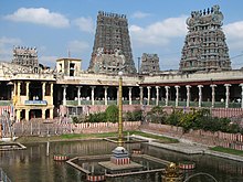
Madurai is one of the most culturally and historically significant cities in South India. The main attraction of the city is the Minakshi Temple in the center of the old town , one of the most outstanding examples of the Dravidian temple architecture , whose gopurams (gate towers) , which can be seen from afar, dominate the skyline of the city. The oldest parts of the Minakshi Temple date from the Pandya period of the 12th – 13th centuries. Century, but the temple got its present form mainly during the Nayak rule in the 16th – 17th centuries. Century. On average, around 20,000 people visit the temple every day.
Other attractions in the city of Madurai are the Tirumalai Nayak Palace , built in the 17th century by the Nayak ruler of the same name, and the Mariamman -eppakulam temple pond. Just eight kilometers south of Madurai is Tirupparankundram , one of six pilgrimage sites ( Arupadaividu ) of the Hindu god Murugan . The god Vishnu is worshiped in Alagar Kovil, 21 kilometers northeast of Madurai.
Administrative division
The Virudhunagar District is divided into seven taluks (sub-districts):
| Taluk | main place | Population (2011) |
|---|---|---|
| Madurai North | Madurai | 494.430 |
| Madurai South | Madurai | 1,391,980 |
| Melur | Melur | 291,398 |
| Peraiyur | Peraiyur | 200,510 |
| Thirumangalam | Thirumangalam | 229,645 |
| Usilampatti | Usilampatti | 195,756 |
| Vadipatti | Vadipatti | 234,533 |
Cities
In the Tirunelveli district there is one city ( Municipal Corporation ), six cities with their own municipalities ( Municipalities ), twelve small towns ( Town Panchayats ) administered according to the Panchayat system and 20 census towns . The number of inhabitants is given according to the 2011 census.
- Municipal Corporation
- Madurai (1,017,865)
- Municipalities
- Anaiyur (63,917)
- Avaniapuram (89,635)
- Melur (40,017)
- Thirumangalam (51,194)
- Tirupparankundram (48,810)
- Usilampatti (35,219)
- Town panchayats
- A. Vellalapatti (8,325)
- Alanganallur (12,331)
- Elumalai (15,746)
- Harveypatti (9,016)
- Palamedu (10,493)
- Paravai (20,042)
- Peraiyur (10,394)
- Sholavandan (22,578)
- T. Kallupatti (10,762)
- Thirunagar (16,598)
- Vadipatti (26,830)
- Vilangudi (30,884)
- Censorship cities
- Arumbanur (6,148)
- Chinna Anuppanadi (26,158)
- Iravadanallur (7,423)
- Kannadendal (31,095)
- Karadipatti (7,289)
- Melamadai (43,797)
- Nagamalaipudukottai (15,769)
- Nagavakulam (23,284)
- Narasingam (5,971)
- Nilaiyur (14,684)
- Othakadai (15,152)
- Sakkimangalam (10,854)
- Samanatham (4,477)
- Samayanallur (9,227)
- Silaiman (6,436)
- Thanakkankulam (14,328)
- Thiruppalai (19.305)
- Vandiyur (28,646)
- Vilacheri (7,787)
- Viraganur (7,121)
Individual evidence
- ↑ Census of India 2011: Primary Census Abstract - Tamil Nadu. (PDF; 873 kB)
- ↑ Climate data from climate-data.org .
- ^ Census of India 2011: Primary Census Data Highlights - Tamil Nadu. Chapter - I Population, Size and Decadal Change.
- ^ Census of India 2011: Primary Census Data Highlights - Tamil Nadu. Chapter - II Scheduled Castes and Scheduled Tribes Population.
- ^ Census of India 2011: Primary Census Data Highlights - Tamil Nadu. Chapter - III Literates and Literacy Rate.
- ^ Census of India 2011: C-1 Population By Religious Community. Tamil Nadu.
- ↑ Census of India 2001: C-15: Population by Mother Tongue (Tamil Nadu), accessed under Tabulations Plan of Census Year - 2001 .
- ↑ a b Census of India 2011: Primary Census Abstract Data Tables: Madurai.
literature
- The Imperial Gazetteer of India. Volume 16: Kotchāndpur to Mahāvinyaka. New edition. Clarendon Press, Oxford 1908, pp. 386-404 , keyword: Madura District .


