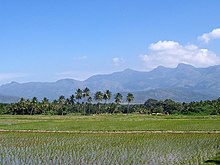
Theni (district)
| Theni District தேனி மாவட்டம் |
|
|---|---|

|
|
| State | Tamil Nadu |
| Administrative headquarters : | Theni Allinagaram |
| Area : | 2,868 km² |
| Residents : | 1,245,899 (2011) |
| Population density : | 434 inhabitants / km² |
| Website : | theni.tn.nic.in |
The District Theni ( Tamil : தேனி மாவட்டம் ) is a district of the Indian state of Tamil Nadu . The administrative center is the city of Theni Allinagaram . The Theni district has an area of 2,868 square kilometers and around 1.2 million inhabitants (2011 census).
geography
Theni District is located in southwest Tamil Nadu at the foot of the Western Ghats . Neighboring districts are Dindigul in the north, Madurai in the east, Virudhunagar in the southeast and Idukki in the west. The latter already belongs to the neighboring state of Kerala .
The area of Theni District is 2,868 square kilometers. The district area includes the Kambam valley (engl. Cumbum Valley ) and the mountains, which surround it in three directions. To the west, the Western Ghats form the natural border with Kerala. In the north are the Palani Mountains and in the south the Varushanad Mountains , both offshoots of the Western Ghats. The Suruliyar , a source of the Vaigai, flows through the Kambam Valley .
In the district of Theni there is a humid tropical climate . The annual mean temperature in Theni is 27.2 ° C, the annual mean precipitation is 869 mm. Most of the rainfall occurs during the northeast monsoon in October and November.
history
The Theni area has long been under the influence of nearby Madurai throughout its history . After the area came under British rule, it was incorporated into the Madras Province in 1801 as part of the Madurai District . After Indian independence in 1947, the area came to the state of Madras, which was reorganized in 1956 according to the language borders of Tamil and renamed Tamil Nadu in 1969. Theni has existed as an independent district since 1996, when it was formed by splitting off the western parts of the Madurai district.
population
According to the 2011 Indian census, the Theni district has 1,245,899 inhabitants. The population density of 434 inhabitants per square kilometer is below the Tamil Nadu average (555 inhabitants per square kilometer). 54 percent of the population of Theni district live in cities. The degree of urbanization is thus slightly higher than the mean value for the state (48 percent). 21 percent of the district's residents are scheduled castes . At 77 percent, the literacy rate is slightly below the Tamil Nadu average (80 percent).
According to the 2011 census , the Hindus make up a large majority of the population of Theni district with 92 percent. There are also minorities of Muslims (5 percent) and Christians (3 percent). As in all of Tamil Nadu, the main language is Tamil . According to the 2001 census, 90 percent of the district's residents speak it as their first language. There are also minorities of speakers of Telugu (6 percent) and Kannada (4 percent).
Administrative division
Theni district is divided into five taluks (sub-districts):
| Taluk | main place | Population (2011) |
|---|---|---|
| Andipatti | Andipatti Jakkampatti | 212,700 |
| Bodinayakkanur | Bodinayakkanur | 180.789 |
| Periyakulam | Periyakulam | 217.358 |
| Theni | Theni Allinagaram | 199.983 |
| Uthamapalayam | Uthamapalayam | 435.069 |
Cities
In the district Theni, there are six cities with its own city government ( Municipalities ) and 22 after the Panchayat managed system townships ( Town Panchayats ). The number of inhabitants is given according to the 2011 census.
- Municipalities
- Bodinayakkanur (75,675)
- Chinnamanur (42,305)
- Gudalur (41,915)
- Kambam (68,090)
- Periyakulam (42,976)
- Theni Allinagaram (94,453)
- Town panchayats
- Andipatti Jakkampatti (27,287)
- B. Meenakshipuram (7,846)
- Boothipuram (11,022)
- Devadanapatti (19,285)
- Ganguvarpatti (11,942)
- Hanumanthampatti (10,619)
- Highways (4,882)
- Kamayagoundanpatti (16,134)
- Kombai (15,960)
- Kuchanur ( 7,024 )
- Markayankottai (6,135)
- Melachokkanathapuram (15,625)
- Odaipatti (13,892)
- Palani Chettipatti (14,879)
- Pannaipuram (9,323)
- Pudupatti (11,511)
- Thamaraikulam (12,372)
- Thenkarai (14,838)
- Thevaram (16,079)
- Uthamapalayam (29,050)
- Vadugapatti (13,204)
- Veerapandi (16,158)
Web links
Individual evidence
- ↑ Census of India 2011: Primary Census Abstract - Tamil Nadu. (PDF; 873 kB)
- ↑ Climate data from climate-data.org .
- ^ Census of India 2011: Primary Census Data Highlights - Tamil Nadu. Chapter - I Population, Size and Decadal Change.
- ^ Census of India 2011: Primary Census Data Highlights - Tamil Nadu. Chapter - II Scheduled Castes and Scheduled Tribes Population.
- ^ Census of India 2011: Primary Census Data Highlights - Tamil Nadu. Chapter - III Literates and Literacy Rate.
- ^ Census of India 2011: C-1 Population By Religious Community. Tamil Nadu.
- ↑ Census of India 2001: C-15: Population by Mother Tongue (Tamil Nadu), accessed under Tabulations Plan of Census Year - 2001 .
- ↑ a b Census of India 2011: Primary Census Abstract Data Tables: Theni.

