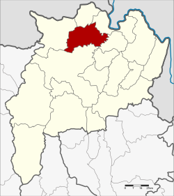
Mae Chan district
|
Mae Chan แม่จัน |
|
|---|---|
| Province: | Chiang Rai |
| Surface: | 791.0 km² |
| Residents: | 99,181 (2013) |
| Population density : | 129.7 U / km² |
| ZIP : | 57110, 57240, 57270 |
| Geocode : | 5707 |
| map | |

|
|
Amphoe Mae Chan ( Thai : อำเภอ แม่จัน , pronunciation: ʔāmpʰɤ̄ː mɛ̂ː tɕān ) is a district ( Amphoe - administrative district) in the north of Chiang Rai Province . Chiang Rai Province is located in the far north of the northern region of Thailand .
geography
Neighboring counties (clockwise from west): the Amphoe Mae Fa Luang , Mae Sai , Chiang Saen, Doi Luang , and Mueang Chiang Rai of Chiang Rai Province.
An important river in the county is the Maenam Kok ( Kok River ) .
The Doi Nang Non , the "Mountain of the Sleeping Lady", is part of the Daen Lao mountain range and the main feature of the geography of Mae Chan.
history
The district was founded as the successor to Mueang Chiang Saen. The original center of the Mueang later became part of the Chiang Saen Luang subdistrict. This was renamed Chiang Saen in 1939 , while the then existing Chiang Saen district was renamed Mae Chan.
administration
Provincial Administration
Mae Chan County is divided into eleven tambon ("subdistricts" or "parishes"), which are further divided into 139 Muban ("villages").
| No. | Surname | Thai | Muban | Pop. |
|---|---|---|---|---|
| 1. | Mae Chan | แม่จัน | 14th | 10,835 |
| 2. | Chan Chwa | จัน จ ว้า | 11 | 7.199 |
| 3. | Mae Kham | แม่ คำ | 14th | 10,515 |
| 4th | Pa Sang | ป่าซาง | 15th | 10,341 |
| 5. | San Sai | สันทราย | 9 | 4,964 |
| 6th | Tha Khao Plueak | ท่า ข้าวเปลือก | 14th | 7,416 |
| 8th. | Pa Tueng | ป่า ตึง | 20th | 21,449 |
| 10. | Mae Rai | แม่ ไร่ | 9 | 8,455 |
| 11. | Si Kham | ศรี ค้ำ | 11 | 5,959 |
| 12. | Chan Chwa Tai | จัน จ ว้า ใต้ | 12 | 8.094 |
| 13. | Chom Sawan | จอม สวรรค์ | 10 | 3,956 |
Note: The missing numbers refer to tambon, which now form the Doi Luang district.
Local administration
There are eight municipalities with "small town" status ( Thesaban Tambon ) in the district:
- Sai Nam Kham (Thai: เทศบาล ตำบล สายน้ำ คำ ) consisting of parts of the Tambon Mae Kham.
- Tha Khao Plueak (Thai: เทศบาล ตำบล ท่า ข้าวเปลือก ) consisting of the complete tambon Tha Khao Plueak.
- Mae Rai (Thai: เทศบาล ตำบล แม่ ไร่ ) consisting of the complete Tambon Mae Rai.
- Chan Chwa (Thai: เทศบาล ตำบล จัน จ ว้า ) consisting of the complete tambon Chan Chwa and Chan Chwa Tai.
- Mae Kham (Thai: เทศบาล ตำบล แม่ คำ ) consisting of parts of the Tambon Mae Kham.
- Mae Chan (Thai: เทศบาล ตำบล แม่จัน ) consisting of parts of the Tambon Mae Chan.
- San Sai (Thai: เทศบาล ตำบล สันทราย ) consisting of parts of the Tambon San Sai.
- Pa Sang (Thai: เทศบาล ตำบล ป่าซาง ) consisting of the complete Tambon Pa Sang.
There are also five " tambon administration organizations " ( องค์การ บริหาร ส่วน ตำบล - Tambon Administrative Organizations, TAO)
- Mae Chan (Thai: องค์การ บริหาร ส่วน ตำบล แม่จัน ) consisting of parts of the Tambon Mae Chan.
- San Sai (Thai: องค์การ บริหาร ส่วน ตำบล สันทราย ) consisting of parts of the Tambon San Sai.
- Pa Tueng (Thai: องค์การ บริหาร ส่วน ตำบล ป่า ตึง ) consisting of the complete tambon Pa Tueng.
- Si Kham (Thai: องค์การ บริหาร ส่วน ตำบล ศรี ค้ำ ) consisting of the complete tambon Si Kham.
- Chom Sawan (Thai: องค์การ บริหาร ส่วน ตำบล จอม สวรรค์ ) consisting of the complete tambon Chom Sawan.
Web links
Individual evidence
- ↑ พระราชกฤษฎีกา เปลี่ยน นาม อำเภอ กิ่ง อำเภอ และ ตำบล บาง แห่ง พุทธศักราช ๒๔๘๒ . In: Royal Gazette . 56, No. 0 ก , April 17, 1939, pp. 354-364.
- ↑ 2013 population statistics ( Thai ) Department of Provincial Administration. Retrieved October 26, 2014.
Coordinates: 20 ° 8 ′ 46.2 ″ N , 99 ° 51 ′ 8.1 ″ E

