Mahlscheid
| Mahlscheid | ||
|---|---|---|
|
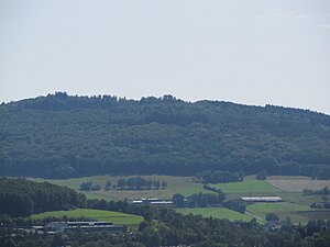
View from the Salchendorfer Memorial to Mahlscheid |
||
| height | 509.3 m above sea level NHN | |
| location | between Herdorf and Neunkirchen ; Altenkirchen district and Siegen-Wittgenstein district ; Rhineland-Palatinate and North Rhine-Westphalia ( Germany ) | |
| Mountains | Southern Hellerbergland , Siegerland or Westerwald | |
| Coordinates | 50 ° 46 ′ 1 ″ N , 7 ° 58 ′ 40 ″ E | |
|
|
||
The Mahlscheid (also called Malscheid ) is 509.3 m above sea level. NHN high side knoll of the Hohenseelbachskopf in the southern Hellerbergland ( Siegerland ). It is located between Herdorf in the Altenkirchen district in Rhineland-Palatinate (RP) and Neunkirchen in the Siegen-Wittgenstein district in North Rhine-Westphalia (NW).
geography
location
The Mahlscheid is located in the border area of the city of Herdorf (RP) in the northwest and the municipality of Neunkirchen (NW) in the north; its (today's) summit belongs to Herdorf. The Heller flows past to the north and the Sotterbach and (beyond) Daade tributaries to the west . About 200 m north-west of the summit, the Silbersee opencast mine ( 450 m ) extends on both sides of the state border , and the Hohenseelbachskopf ( 517.5 m ) lies 1 km south-east on the border .
Natural allocation
The Mahlscheid belongs in the natural spatial main unit group Süderbergland ( Bergisch-Sauerland Mountains ; No. 33), in the main unit Siegerland (331) and in the subunit Hellerbergland (331.3) to the natural area Südliches Hellerbergland (331.32). Its landscape falls to the north-east into the natural area of Mittleres Hellertal (331.31) and to the north-west and north into the natural area of the northern Hellerbergland (331.30).
Protected areas
There are two nature conservation areas (NSG) on the Mahlscheid : on the North Rhine-Westphalian side the NSG Mahlscheid ( CDDA -Nr. 164544; designated 1990; 17.54 hectares) and on the Rhineland-Palatinate area the (eponymous) NSG Mahlscheid (CDDA-No . 164545; 1992; 1.0769 km² ). On the Rhineland-Palatinate side there are parts of the fauna-flora-habitat area forests on the Hohenseelbachkopf (FFH no. 5213-301; 10.25 km²). In addition, parts of the EU bird protection areas (VSG) " Forests and meadows near Burbach and Neunkirchen " (VSG no. 5214-401; 46.5456 km²) on the North Rhine-Westphalian area and Westerwald (VSG no. 5312- 401; 289.48 km²) on the Rhineland-Palatinate side.
Geology and history
The Mahlscheid and the Hohenseelbachskopf represent several large basalt peaks that were created here around seven million years ago through volcanic activity. Until the beginning of the 20th century, the basalt dome of the Mahlscheid was visible from afar. Basalt mining for road construction - which was carried out until the 1950s - led to the removal of the dome and created the mining crater that can be found today with the Silver Lake in it. In the steep walls of the crater, however, basalt columns towering up to 40 m are still visible.
The Mahlscheid, the Hohenseelbachskopf and the Druidenstein , only about 5 km away, were probably important Celtic places of worship. Around the 4th century BC Chr. , The area was the Mahlscheid of Celtic hill forts existed.
tourism
Around the Mahlscheid there are many forest and hiking trails popular with hikers and mountain bikers. B. the European long-distance hiking trail E1 , which runs from west to south . To the east of the Mahlscheid is the Hohenseelbachskopf forest restaurant , which is currently frequented by local hikers and mountain bikers.
Individual evidence
- ↑ a b Map service of the landscape information system of the Rhineland-Palatinate Nature Conservation Administration (LANIS map) ( notes )
- ↑ Heinz Fischer: Geographical Land Survey: The natural spatial units on sheet 124 Siegen. Federal Institute for Regional Studies, Bad Godesberg 1972. → Online map (PDF; 4.1 MB)
- ↑ Map services of the Federal Agency for Nature Conservation ( information )
Web links
- Silbersee on Mahlscheid , on panorama-photo.net


