
Maroggia
| Maroggia | |
|---|---|
 |
|
| State : |
|
| Canton : |
|
| District : | Lugano district |
| Circle : | Ceresio district |
| BFS no. : | 5195 |
| Postal code : | 6817 |
| UN / LOCODE : | CH MRO |
| Coordinates : | 718 819 / 88295 |
| Height : | 277 m above sea level M. |
| Height range : | 270–602 m above sea level M. |
| Area : | 0.99 km² |
| Residents: | 686 (December 31, 2018) |
| Population density : | 693 inhabitants per km² |
| Website: | www.maroggia.ch |
 Maroggia |
|
| Location of the municipality | |
  |
|
Maroggia is a municipality in the Ceresio district in the Lugano district in the canton of Ticino in Switzerland .
geography

The village is located on the east bank of Lake Lugano at the foot of Monte Generoso and 2 km north of the Melano station on the Bellinzona-Chiasso line of the Swiss Federal Railways .
history
The village has been inhabited since the Iron Age; In 1906 a northern Truscan inscription and in 1926 a Roman stele were discovered. The Lombard king Liutprand donated the village to the church of San Carpoforo in Como around 724 , later it was transferred to the Benedictine abbey of Sant'Ambrogio in Milan . In 1798, Maroggia joined the short-lived Republic of Riva San Vitale .
population
| Population development | ||||||||||||||
|---|---|---|---|---|---|---|---|---|---|---|---|---|---|---|
| year | 1636 | 1791 | 1850 | 1900 | 1950 | 1970 | 1980 | 1990 | 2000 | 2005 | 2010 | 2012 | 2014 | 2017 |
| Residents | 114 | 151 | 211 | 414 | 577 | 689 | 554 | 575 | 571 | 586 | 557 | 575 | 597 | 683 |
Attractions
- The parish church of San Pietro was first mentioned in 1579, renovated in 1640 and consecrated in 1643
- Ossuary
- Oratorio Madonna della Cintura (1731–1766) and restored by the architect Tita Carloni (1975–1976)
- Ex Don Bosco College with frescoes
- three holiday homes built by the architect Rino Tami (1953, 1954, 1963)
- Maroggia Mill (1897)
Sports
- Associazione Sportiva Maroggia
camping
In Maroggia there is a small TCS campsite called Paradiso .
Personalities
literature
- Simona Martinoli u. a .: Guida d'arte della Svizzera italiana. Ed. Society for Swiss Art History GSK, Edizioni Casagrande, Bellinzona 2007, ISBN 978-88-7713-482-0 , pp. 362–363.
- Giuseppe Negro: Maroggia. In: Historical Lexicon of Switzerland . March 2, 2010 , accessed December 30, 2019 .
- Cesare Santi, Il collegio Don Bosco di Maroggia. In Almanacco di vita chiassese e del Mendrisiotto , Chiasso 2003, pp. 27-33.
- Celestino Trezzini : Maroggia. In: Historisch-Biographisches Lexikon der Schweiz , Volume 5, Maillard - Monod. , Attinger, Neuenburg 1929, p. 30 ( digitized version ).
photos

On the bank by the parish church of San Pietro
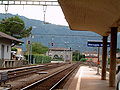
Maroggia railway station

Confluence of the Giessbach Mara

San Nicolao tunnel (architect Rino Tami)

Modern holiday homes (2017)


Web links
- Maroggia on the ETHorama platform
- Data from the municipality of Maroggia
- Office for Statistics of the Canton of Ticino: Maroggia (Italian)
- Maroggia on www.artistiticinesi-ineuropa.ch
- Maroggia: inventory of cultural assets of the Canton of Ticino
- Maroggia on elexikon.ch
Individual evidence
- ↑ Permanent and non-permanent resident population by year, canton, district, municipality, population type and gender (permanent resident population). In: bfs. admin.ch . Federal Statistical Office (FSO), August 31, 2019, accessed on December 22, 2019 .
- ^ Giuseppe Negro: Maroggia. In: Historical Lexicon of Switzerland . October 27, 2009 .
- ^ Giuseppe Negro: Maroggia. In: Historical Lexicon of Switzerland . October 27, 2009 .
- ↑ a b c d e f Simona Martinoli and others: Guida d'arte della Svizzera italiana. Edited by the Society for Swiss Art History GSK, Edizioni Casagrande, Bellinzona 2007, ISBN 978-88-7713-482-0 , pp. 362–363.
- ^ Associazione Sportiva Maroggia