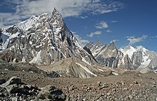
Masherbrum Mountains
| Masherbrum Mountains | ||
|---|---|---|
|
The Masherbrum is the highest mountain in the chain. |
||
| Highest peak | Masherbrum ( 7821 m ) | |
| location | Gilgit-Baltistan , Pakistan | |
| part of | Karakoram | |
|
|
||
| Coordinates | 35 ° 38 ′ N , 76 ° 18 ′ E | |
| Type | Fold Mountains | |
|
Chogolisa (left) and other peaks of the Masherbrum Mountains from K2. |
||
The Masherbrum Mountains form a mountain range of the Karakoram in the autonomous Pakistani province of Gilgit-Baltistan . The highest mountain in the chain is named after the 7,821 meter high Masherbrum . Other well-known mountains are the hipped roof-shaped Chogolisa and the Miter Peak at Concordiaplatz .
location
Limits
The Masherbrum Mountains extend from the Baltoro Kangri in the east to the Koser Gunge Group in the west over a length of more than 100 kilometers. They belong to the so-called Little Karakoram, which means the mountain ranges south and west of the large Karakoram glaciers and the Muztagh chains of the Great Karakoram behind them. The Masherbrum Mountains in the north and northeast are separated from the Baltoro Muztagh with the eight-thousanders of the Karakoram by the Baltoro Glacier flowing west and its tributary, the Abruzzi Glacier . The northern limit of the mountain range is continued by the Braldu as an outflow from the Baltoro Glacier. Beyond its valley, west of the Baltoro Muztagh, lie the Panmah Muztagh and the Spantik-Sosbun Mountains (between which the Biafo Glacier flows as the border between the small and large Karakoram and the Braldu). The Braldu forms with a northern tributary the Shigar , which flows south and flows into the Indus at Skardu . Shigar and Indus form the western and southern frame of the mountain range.
The Conway Saddle between Baltoro Kangri and Sia Kangri connects the Masherbrum Mountains in the east with the Karakoram main chain. From this saddle the Abruzzi Glacier flows north to the Baltoro. The Kondus Glacier flows south and, together with its outflow, the Kondus River, forms the eastern border of the mountain range and separates it from the Saltoro Mountains . The Kondus River flows further to the west and flows into the Hushe River, which flows into the Shyok a little later . Kondus, Hushe and Shyok form the southern border in the eastern part of the mountain range until the Shyok flows into the Indus. The Shyok separates the Masherbrum Mountains from the Ladakh chain , the Indus separates them from the northern foothills of the main Himalayan ridge.
Inside the chain
While the chain rises steeply over the Baltoro valley in the north, the southern part is criss-crossed by longer valleys. The highest mountains are in the eastern part immediately south of the Baltoro Glacier. The chain flattens further to the west, the Mango-Gusor group reaches a height of almost 6000 meters, the Koser-Gunge group, which adjoins to the west, does not exceed this height. South of the Chogolisa joins the part of the chain in which the mountains K6, Link Sar and K7 are located. This area is called after the Charakusagletscher as Charakusatal and lies between the Kondus- and the Hushetal. The Hushetal drains the south sides of Chogolisa and Masherbrum and their neighbors. The upper Baltoro glacier can be reached from the Hushetal via the Gondogoro La . Many trekking tourists who visit the eight-thousanders of the Karakoram choose the route through the Hushetal as their way back to Skardu.
mountains

| rank | in the Karakoram | in Asia | mountain | height | Notch height | reference | |
|---|---|---|---|---|---|---|---|
| 1. | 8th. | 22nd | Masherbrum | 7821 m | 2457 m | K2 | |
| 2. | 14th | 36. | Chogolisa | 7668 m | 1624 m | Hidden Peak (Gasherbrum I) | |
| 3. | 38. | 81. | Baltoro Kangri | 7300 m | 1121 m | Chogolisa | |
| 4th | 41. | 87. | K6 (Baltistan Peak) | 7282 m | 1962 m | Hidden Peak | |
| 5. | 127. | Mandu Kangri | 7127 m | 630 m | Masherbrum | ||
| 6th | 153. | Link Sar | 7041 m | 1011 m | K6 | ||
| 7th | 204. | K7 | 6934 m | 794 m | Link Sar | ||
| 8th. | 282. | Gondogoro Ri | 6810 m | 1330 m | Yermanendu Kangri | ||
| 9. | 305 | Biarchedi | 6781 m | 553 m | Gondogoro Ri |
Includes all independent mountains above 6750 meters with a notch height of 500 meters.
Other well-known mountains are Miter Peak at Concordiaplatz and Laila Peak , a steep rock spire above the Gondogoro Glacier .
Web links
- Eduard Koblmüller: "The ascent of K6" (first ascent of K6) in the Alpine Journal 1971 (PDF file; 2.8 MB)
Individual evidence
- ↑ List of all mountains in Asia with a height of more than 6750 meters, www.8000ers.com , as of January 18, 2011, accessed on February 1, 2011.


