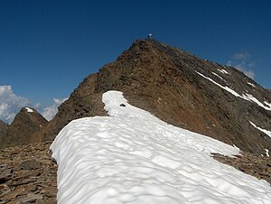
Roteck
| Roteck | ||
|---|---|---|
| height | 3337 m slm | |
| location | South Tyrol , Italy | |
| Mountains | Texel Group , Ötztal Alps | |
| Dominance | 4.93 km → Falschunggspitze | |
| Notch height | 483 m ↓ Johannesscharte | |
| Coordinates | 46 ° 43 '23 " N , 10 ° 59' 4" E | |
|
|
||
| First ascent | July 14, 1872 by Theodor Petersen , Rochus Raffeiner, Illdefons Kobler | |
| Normal way | East ridge (I) from the Lodnerhütte | |
| particularities | highest mountain in the Texel group | |
The Roteck ( Italian Monte Rosso ) is at 3337 m the highest point in the Texel Group in South Tyrol . At the end of the 19th century the mountain was still called Zehnerspitze and was used by the residents of the Pfossental to determine the time. The mountain is under protection in the Texel Group Nature Park .
The first recorded ascent was made on July 14, 1872 by Theodor Petersen , between 1869 and 1894 board member of the Frankfurt am Main section of the German Alpine Club , Rochus Raffeiner, blacksmith from Katharinaberg , and the shepherd Illdefons Kobler over the southwest ridge .
The usual ascent takes place without touching the glacier from the Lodnerhütte in the target valley and is largely considered relatively easy. However, the last upswing on the east ridge , which is provided with various iron guards, is very steep and exposed. There have been two rockfalls at this key point in recent years, which increases the difficulty a little. A via ferrata set is recommended.
The summit cross was attached in 1978.
literature
- Walter Klier : Alpine Club Guide Ötztal Alps . Bergverlag Rudolf Rother . Munich 1993. ISBN 3-7633-1116-5
- Hanspaul Menara : The most beautiful 3000m peaks in South Tyrol. 70 worthwhile alpine tours. Athesia, Bozen 2014, ISBN 978-88-8266-911-9
Web links
Individual evidence
- ↑ www.outdooractive.com: Roteck: only accessible with via ferrata equipment , August 19, 2015.

