Monteagudo (Bolivia)
| Monteagudo | ||
|---|---|---|
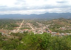
 Monteagudo panorama |
||
| Basic data | ||
| Residents (state) | 9135 pop. (2012 census) | |
| rank | Rank 56 | |
| height | 1144 m | |
| Post Code | 01-0501-0101-7001 | |
| Telephone code | (+591) | |
| Coordinates | 19 ° 48 ′ S , 63 ° 57 ′ W | |
|
|
||
| politics | ||
| Department | Chuquisaca | |
| province | Hernando Siles Province | |
| climate | ||
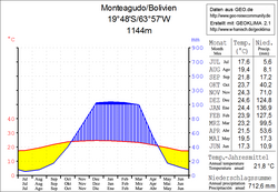
 Climate diagram Monteagudo |
||
Monteagudo is a small town in the Chuquisaca department in the South American Andean state of Bolivia . The city is named after Bernardo de Monteagudo Cáceres (1789-1825), who was instrumental in the Chuquisaca revolution of May 25, 1809.
location
Monteagudo is the seat of the administration of the province of Hernando Siles and a central place in the district ( Bolivian : Municipio ) Monteagudo . The city is located at an altitude of 1144 m at the mouth of the Río Sauces in the Río Bañado and is framed by north-south running mountain ranges with lush vegetation.
climate
The small town is located in the humid, sub-Andean Chaco of Bolivia. In the months of July to September there is a pronounced dry season in the Monteagudo area , while the months of December and January are characterized by sometimes heavy rains.
Transport network
Monteagudo is located at a distance of 317 kilometers by road southeast of Sucre , the capital of the department.
From Sucre, the Ruta 6 trunk road leads south-east via Tarabuco , Zudáñez , Tomina and Padilla to Monteagudo and on via Lagunillas and Boyuibe to the border with Paraguay . Since less than a third of the route between Sucre and Monteagudo is paved, the bus ride takes about 8 hours in dry weather, while the road conditions on the dirt and gravel roads are difficult to predict in wet weather.
To the northeast, Monteagudo is connected to Santa Cruz , the capital of the neighboring department of Santa Cruz . The unpaved Ruta 6 leads first in an easterly direction to Ipatí , 104 kilometers away , from there the asphalted Ruta 9 leads for another 255 kilometers north to Santa Cruz .
The Monteagudo Airport has been served by commercial flights since November 2017 and is connected to Santa Cruz, Cochabamba and La Paz.
population
The city's population has almost doubled over the past two decades:
| year | Residents | source |
|---|---|---|
| 1992 | 5 130 | census |
| 2001 | 7 285 | census |
| 2012 | 9 135 | census |
Individual evidence
- ↑ BoA inaugura vuelos comerciales en aeropuerto de Monteagudo in La Razón (Spanish)
- ^ INE - Instituto Nacional de Estadística Bolivia 1992
- ^ INE - Instituto Nacional de Estadística Bolivia 2001
- ↑ INE - Instituto Nacional de Estadística Bolivia 2012 ( Memento of the original from July 22, 2011 in the Internet Archive ) Info: The archive link has been inserted automatically and has not yet been checked. Please check the original and archive link according to the instructions and then remove this notice.
Web links
- Relief map of the Charagua region 1: 250,000 (PDF; 6.23 MB)
- Municipio Monteagudo - General Maps No. 10501
- Municipio Monteagudo - detailed map and population data (PDF; 944 kB)
- Departamento Chuquisaca - Social data ( Spanish ) (PDF; 4.21 MB)


