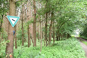
Moss pine forest of Dudenhofen
|
Moss pine forest of Dudenhofen
|
||
|
Sign in the NSG Mooskiefernwald von Dudenhofen |
||
| location | Rodgau , Dudenhofen , Hesse , Germany | |
| surface | 36.11 ha | |
| Identifier | 1438030 | |
| WDPA ID | 3188072 | |
| Natura 2000 ID | 6019-304 | |
| Geographical location | 50 ° 0 ′ N , 8 ° 56 ′ E | |
|
|
||
| Sea level | from 145 m above sea level NN up to 160 m above sea level NN | |
| Setup date | 1999 | |
| administration | Lower nature conservation authority in the Offenbach district | |
The nature reserve Mooskiefernwald von Dudenhofen (NSG identification 1438030) is located in the Hessian district of Offenbach . It encompasses around 36.11 hectares of forest and meadows east of the Opel test site and east of the urban area of Rodgau - Dudenhofen .
Area description
The nature reserve is located at the eastern end of the district of Dudenhofen. The area consists of large pine forests , which form a valuable biotope for bird species such as the hawk , black and green woodpecker , redstart , goat milker and wryneck .
Protection purpose
The purpose of the NSG designation is to preserve this type of landscape in its special character over a large area and to put the valuable ground vegetation under protection. The golden wintergreen and creeping reticulate leaves grow there . The aim of the protection is to preserve the moss-pine forest, which is also important in terms of regional culture, as a habitat for the multitude of rare and endangered animal and plant communities that have been adapted to the local conditions.
Nature reserves in the Offenbach district
Web links
Individual evidence
- ↑ nature reserves. In: Kreis-offenbach.de. Retrieved September 20, 2018 .
- ↑ cf. Municipal and field boundaries in BürgerGIS of the Offenbach


