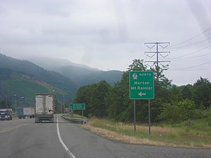
Morton (Washington)
| Morton | |
|---|---|
 On the outskirts of Morton |
|
| Location in Washington | |
| Basic data | |
| Foundation : | 1871 |
| State : | United States |
| State : | Washington |
| County : | Lewis County |
| Coordinates : | 46 ° 33 ′ N , 122 ° 17 ′ W |
| Time zone : | Pacific ( UTC − 8 / −7 ) |
| Residents : | 1,126 (as of 2010) |
| Population density : | 417 inhabitants per km 2 |
| Area : | 2.7 km 2 (approx. 1 mi 2 ) of which 2.7 km 2 (approx. 1 mi 2 ) are land |
| Height : | 289 m |
| Postal code : | 98356 |
| Area code : | +1 360 |
| FIPS : | 53-47175 |
| GNIS ID : | 1523383 |
Morton is a small town in Lewis County of middle-Southwest US -amerikanischen the State of Washington . At the 2010 census , Morton had 1,126 residents.
geography
Morton lies at 46 ° 33'28 "north latitude and 122 ° 16'47" west longitude and extends over 2.7 km², which consists exclusively of land.
The place is about 20 miles north of Riffe Lake , a reservoir of the Cowlitz River , which flows into the Columbia River at Longview (across from Portland , Oregon ) .
Morton is located southwest of Mount Rainier , the highest peak in the Cascade Range at 4,392 m . In the immediate vicinity of Morton are the Mount Rainier National Park , the Snoqualmie National Forest and the Gifford Pinchot National Forest with the Mount St. Helens National Volcanic Monument .
The closest locations are Glenoma (11.8 km southwest), Mossyrock (18.6 km west-southwest), Carlson (18.1 km north-northeast), and Cinebar (14.2 km west). The closest major cities are Seattle (144 km north) and Portland, Oregon (174 km south-southwest).
US Highway 12 runs through Morton and runs through almost the entire United States in a west-east direction. In the center of Morton, the highway meets State Routes 7 and 508 .
history
In 1871, James Fletcher was the first to settle in what is now the city. The newly created place was named in 1889 after Levi P. Morton (1824-1920), the 22nd Vice President of the USA (1889-1893).
On January 7, 1913, Morton got the official status of a self-governing community ( Incorporation ). The main sources of income were logging in the surrounding forests, harvesting the cascara bark and mining cinnabarite ( cinnabar ). In the 1950s, Morton was referred to as the "tie mill capital of the world", as railroad ties were manufactured here on a large scale .
Demographic data
| Population development | |||
|---|---|---|---|
| Census | Residents | ± in% | |
| 1920 | 522 | - | |
| 1930 | 461 | -11.7% | |
| 1940 | 778 | 68.8% | |
| 1950 | 1140 | 46.5% | |
| 1960 | 1183 | 3.8% | |
| 1970 | 1134 | -4.1% | |
| 1980 | 1264 | 11.5% | |
| 1990 | 1130 | -10.6% | |
| 2000 | 1045 | -7.5% | |
| 2010 | 1126 | 7.8% | |
| 1920–1990 2000 2010 | |||
In the official census in 2000 , the population was 1,045. These were distributed to 437 households in 273 families. The population density was 388.0 inhabitants per square kilometer. There were 487 residential buildings, which corresponded to a building density of 180.8 buildings per square kilometer.
The population in 2000 was 95.4 percent white , 1.2 percent Native American , 0.7 percent Asian and 0.4 percent other. 2.3 percent said they came from at least two of these groups. 1.2 percent of the population were Hispanics belonging to any of the named groups.
24.7 percent were under 18 years of age, 7.0 percent between 18 and 24, 21.9 percent from 25 to 44, 22.1 percent from 45 to 64 and 24.3 percent 65 and over. The mean age was 43 years. For every 100 women there were statistically 90.0 men, for those over 18 years of age 83.0.
The median income per household was 31,063 US dollars (USD), the median family income 37,054 USD. The median income for men was $ 36,607 and that for women was $ 23,438. The per capita income was $ 16,275. Around 6.9 percent of families and 14.0 percent of the total population had their income below the poverty line .
Individual evidence
- ^ US Census 2010.Retrieved December 7, 2011
- ↑ Google Maps: Morton, WA - Riffe Lake. Retrieved December 7, 2011
- ↑ Google Maps: Neighborhoods of Morton, WA. Accessed December 7, 2011
- ↑ Google Maps: Morton, WA - Seattle, WA.Retrieved December 7, 2011
- ↑ Google Maps: Morton, WA - Portland, OR.Retrieved December 7, 2011
- ↑ Harry M. Majors: Exploring Washington . Van Winkle Publishing Co, 1975, ISBN 9780918664006 , p. 122.
- ↑ LaVonne M. Sparkman, From Homestead to Lakebed (Spakrman Publications, 1994) p. 72. ISBN 0-89288-249-2
- ^ US Decennial Census. Retrieved December 7, 2011
- ^ Census 2000 - Morton, WA Retrieved December 7, 2011
- ↑ 2010 Census - Morton, WA Retrieved December 7, 2011
- ^ US Census Bureau - Morton, WA. Retrieved December 7, 2011

