Lewis County (Washington)
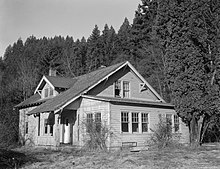
 Lewis County Courthouse |
|
| administration | |
|---|---|
| US state : | Washington |
| Administrative headquarters : | Chehalis |
| Foundation : | December 19, 1845 |
| Made up from: | Original county |
| Area code : | 001 360 |
| Demographics | |
| Residents : | 75,455 (2010) |
| Population density : | 12.1 inhabitants / km 2 |
| geography | |
| Total area : | 6310 km² |
| Water surface : | 74 km² |
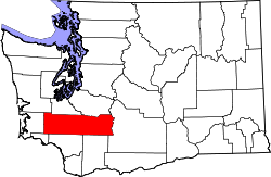
| map | |
| Website : lewiscountywa.gov | |
The Lewis County is a county in the US state of Washington . In 2010 the county had 75,455 residents and a population density of 12.1 people per square kilometer. The county seat is Chehalis .
geography
The county is located in the central southwest of Washington and is crossed by the Cascade Range in a north-south direction . The Cowlitz River drains most of the area. Lewis County covers an area of 6,310 square kilometers; 74 square kilometers (1.18 percent) of this is water. It borders on the following neighboring counties:
| Grays Harbor County | Thurston County | Pierce County |
| Pacific County |

|
Yakima County |
| Wahkiakum County | Cowlitz County | Skamania County |
National protected areas
Lewis County each has a share of the following protected areas:
- Gifford Pinchot National Forest
- Mount Baker-Snoqualmie National Forest
- Mount Rainier National Park
- Mount St. Helens National Volcanic Monument
history
| Population development | |||
|---|---|---|---|
| Census | Residents | ± in% | |
| 1850 | 558 | - | |
| 1860 | 384 | -31.2% | |
| 1870 | 888 | 131.3% | |
| 1880 | 2600 | 192.8% | |
| 1890 | 11,499 | 342.3% | |
| 1900 | 15,157 | 31.8% | |
| 1910 | 32,127 | 112% | |
| 1920 | 36,840 | 14.7% | |
| 1930 | 40,034 | 8.7% | |
| 1940 | 41,393 | 3.4% | |
| 1950 | 43,755 | 5.7% | |
| 1960 | 41,858 | -4.3% | |
| 1970 | 45,467 | 8.6% | |
| 1980 | 56.025 | 23.2% | |
| 1990 | 59,358 | 5.9% | |
| 2000 | 68,600 | 15.6% | |
| 2010 | 75,455 | 10% | |
| Before 1900 1900–1990 2000–2010 | |||
Lewis County was formed on December 19, 1845 as the original county from the Oregon Territory . It was named after the explorer, soldier and administrator Meriwether Lewis . He was instrumental in the planning and execution of the Lewis and Clark Expedition ( Corps of Discovery , Discovery Corps involved).
Demographic data

As of the 2010 census , Lewis County had 75,455 people in 28,297 households. The population density was 12.1 inhabitants per square kilometer.
The racial the population was composed of 89.7 percent white, 0.5 percent African American, 1.4 percent Native American, 0.9 percent Asian and other ethnic groups; 3.2 percent were descended from two or more races. Regardless of ethnicity, 8.7 percent of the population was Hispanic or Latino of any race.
Statistically, 2.56 people lived in each of the 28,297 households.
23.1 percent of the population were under 18 years old, 59.6 percent were between 18 and 64 and 17.3 percent were 65 years or older. 50.0 percent of the population was female.
The median income for a household was 42,365 USD . The per capita income was $ 21,689. 15.1 percent of the population lived below the poverty line.
Places in Lewis County
other unincorporated communities
structure
Lewis County is divided into 12 Census County Divisions (CCD):
| CCD | Population (2010) | FIPS |
|---|---|---|
| Big Bottom CCD | 2911 | 53-90208 |
| Bunker CCD | 3379 | 53-90352 |
| Centralia-Chehalis CCD | 31,069 | 53-90512 |
| Ethel CCD | 3303 | 53-91088 |
| Logan Hill CCD | 3819 | 53-91648 |
| Mineral CCD | 4175 | 53-91984 |
| Morton CCD | 2931 | 53-92016 |
| Mossyrock CCD | 4652 | 53-92048 |
| Napavine CCD | 5571 | 53-92120 |
| Newaukum Prairie CCD | 2608 | 53-92146 |
| Toledo-Vader CCD | 3945 | 53-93448 |
| Winlock-Pe Ell CCD | 7092 | 53-93816 |
Web links
- Official website
- Entry in the Washington encyclopedia HistoryLink (English)
- US Census Bureau, State & County QuickFacts - Lewis County
- www.city-data.com - Lewis County
Individual evidence
- ↑ Lewis County in the Geographic Names Information System of the United States Geological Survey Accessed 22 February 2011
- ↑ a b c U.S. Census Bureau, State & County QuickFacts - Lewis County, MO ( Memento of the original from July 13, 2011 on WebCite ) Info: The archive link was automatically inserted and not yet checked. Please check the original and archive link according to the instructions and then remove this notice. Retrieved May 10, 2012
- ^ National Association of Counties.Retrieved December 7, 2011
- ^ US Census Bureau _ Census of Population and Housing.Retrieved February 28, 2011
- ^ Extract from Census.gov.Retrieved February 28, 2011
- ↑ Extract from the National Register of Historic Places - No. 86000816. Retrieved December 7, 2011
- ↑ Missouri Census Data Center - Washington ( page no longer available , search in web archives ) Info: The link was automatically marked as defective. Please check the link according to the instructions and then remove this notice. Retrieved May 10, 2012
Coordinates: 46 ° 37 ′ N , 122 ° 27 ′ W


