
Wahkiakum County
.jpg) Wahkiakum County Courthouse in Cathlamet |
|
| administration | |
|---|---|
| US state : | Washington |
| Administrative headquarters : | Cathlamet |
| Foundation : | 1854 |
| Demographics | |
| Residents : | 3978 (2010) |
| Population density : | 5.8 inhabitants / km 2 |
| geography | |
| Total area : | 743 km² |
| Water surface : | 58 km² |
| map | |
 |
|
| Website : www.co.wahkiakum.wa.us | |
Wahkiakum County is a county in the state of Washington in the United States . It has 3,824 inhabitants. The county seat is Cathlamet .
geography
Wahkiakum County is mostly located on the north bank of the Columbia River , the border river between Washington and Oregon . The inhabited river island of Puget Island and several other, smaller islands also belong to the county . Two rivers, the Grays River and the Elochoman River , flow through the county and flow into the Columbia.
The county covers an area of 743 square kilometers, of which 684 square kilometers are land and 58 square kilometers (7.83 percent) are water. The county is the smallest county in Washington and in the lower third by population density.
Wahkiakum County is bordered on the land side from west to east by Pacific Counties , Lewis Counties, and Cowlitz Counties . On the other side of the Columbia are Columbia and Clatsop Counties .
history
The county was formed in 1854. The name goes back to a Chinook strain, the Wahkiakum , which were first described by Lewis and Clark in 1805 .
| Population development | |||
|---|---|---|---|
| Census | Residents | ± in% | |
| 1860 | 42 | - | |
| 1870 | 270 | 542.9% | |
| 1880 | 1598 | 491.9% | |
| 1890 | 2526 | 58.1% | |
| 1900 | 2819 | 11.6% | |
| 1910 | 3285 | 16.5% | |
| 1920 | 3472 | 5.7% | |
| 1930 | 3862 | 11.2% | |
| 1940 | 4286 | 11% | |
| 1950 | 3835 | -10.5% | |
| 1960 | 3426 | -10.7% | |
| 1970 | 3592 | 4.8% | |
| 1980 | 3832 | 6.7% | |
| 1990 | 3327 | -13.2% | |
| 2000 | 3824 | 14.9% | |
| 2010 | 3978 | 4% | |
| Before 1900
1900-1990 2000 |
|||
Cities and towns
City ( Town )
Census-designated places
- Altoona
- Deep river
- East Cathlamet
- Grays River
- Lower Elochoman
- Puget Island
- Rosburg
- Skamokawa Valley
- Upper Elochoman
Infrastructure
Washington State Route 4 runs through the county in an east-west direction . From Cathlamet you can cross the Columbia via Washington State Route 409 and a ferry .
gallery

Forest workers on the Deep River, 1904

The Deep River Pioneer Lutheran Church in Deep River , listed on NRHP No. 74001983
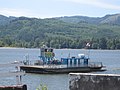
Ferry across the Columbia between Puget Island and Westport

The Julia Butler Hansen Bridge on Washington State Route 409

View of Puget Island (front) and Cathlamet
.jpg)


Web links
Individual evidence
- ↑ Wahkiakum County in the United States Geological Survey's Geographic Names Information System . Retrieved February 22, 2011
- ^ Robert H. Ruby, John Arthur Brown: A guide to the Indian tribes of the Pacific Northwest , University of Oklahoma Press 1992, p. 257.
- ^ US Census Bureau _ Census of Population and Housing . Retrieved February 28, 2011
- ↑ Extract from Census.gov . Retrieved February 28, 2011
- ↑ Excerpt from factfinder.census.gov.Retrieved February 28, 2011
- ^ Extract from the National Register of Historic Places . Retrieved March 13, 2011
List of counties in Washington
Adams |
Asotin |
Benton |
Chelan |
Clallam |
Clark |
Columbia |
Cowlitz |
Douglas |
Ferry |
Franklin |
Garfield |
Grant |
Grays Harbor |
Iceland |
Jefferson |
King |
Kitsap |
Kittitas |
Click quote |
Lewis |
Lincoln |
Mason |
Okanogan |
Pacific |
Pend Oreille |
Pierce |
San Juan |
Skagit |
Skamania |
Snohomish |
Spokane |
Stevens |
Thurston |
Wahkiacum |
Walla Walla |
Whatcom |
Whitman |
Yakima
Coordinates: 46 ° 17 ′ N , 123 ° 26 ′ W