
Mostecký potok
|
Mostecký potok Glöcklbach |
||
 Mostecký potok (Glöcklbach) |
||
| Data | ||
| location | Czech Republic | |
| River system | Elbe | |
| Drain over | Radbuza → Berounka → Moldau → Elbe → North Sea | |
| source | on the southern slope of the Malý Z from 49 ° 31 ′ 57 ″ N , 12 ° 38 ′ 7 ″ E |
|
| Source height | 828 m above sea level NHN | |
| muzzle | in Mostek (Rybník nad Radbuzou) Coordinates: 49 ° 32 ′ 38 " N , 12 ° 40 ′ 18" E 49 ° 32 ′ 38 " N , 12 ° 40 ′ 18" E |
|
| Mouth height | 520 m nm | |
| Height difference | 308 m | |
| Bottom slope | 77 ‰ | |
| length | about 4 km | |
| Catchment area | approx. 3.3 km² | |
The Mostecký potok (German Glöcklbach ) is a left tributary of the Radbuza in the Czech Republic .
course
![]() Map with all the coordinates of the settlements and desolations on the run: OSM | WikiMap
Map with all the coordinates of the settlements and desolations on the run: OSM | WikiMap
The Mostecký potok rises on the southern slope of the Malý Zvon in the area of the municipality of Bělá nad Radbuzou . Its source is only about 10 meters north of the German border.
On the German side as far as the German-Czech border, a flat saddle area consisting of clearing and forest areas extends here, on which the settlement of the same name, today in a desolate place, Ironlohe ⊙ , stood. Swampy wet meadows lie directly along the border. The water that seeps from them feeds small rivulets that merge with the Mostecký potok southeast of its source. The Mostecký potok then flows in an easterly direction down the steep slope of the Malý Zvon. After a kilometer, it takes in another spring stream from the south, which flows down the northwest slope of the Železný vrch.
The Mostecký potok then turns to the northeast. About 400 meters further on, it passes under the mountain road that leads from Pleš to Mostek . Here he passes the Štráská Huť (rhinestone huts) desert. ⊙ The stream changes from the area of the municipality of Bělá nad Radbuzou to that of the municipality of Rybník nad Radbuzou .
The aforementioned mountain road now follows the stream at a short distance to the right of the stream next to the eastern slope of the Malý Zvon. From late March to early April, the white butterbur blooms between the roadside and the stream . Towards the end of its mountain valley, the Mostecký potok passes the Jánská Huť (Johanneshütten) desert. ⊙ On its next, last 500 meters, it crosses under the valley road next to its receiving water and then flows into the Radbuza from the left at Mostek ⊙ .
Catchment area and main European watershed
The catchment area is around 3.3 km². It stretches in a wedge shape to the northeast, for example from Weingartenfelsen on the elevation south of the saddleügelhorn, about 3.6 km northeast to the confluence at Mosteck.
In the upper part it borders on the European main watershed between the Elbe on this side and the Danube on the other. From Malý Z from south over the saddle of theügellohe to the Weingartenfelsen, the outlying area drains over the Ascha , the Schwarzach , the Naab and the Danube into the Black Sea ; Only about 200 meters west of the source of the Mostecký potok is the Weißbrunnen, the uppermost source of the Ascha, initially known as Weißbach . From the Weingartenfelsen this hydrologically important divide runs further east-southeast to the Velká Skalá, on its opposite side the Bavarian Schwarzach , which also runs to the Schwarzach, competes with the second mentioned upper reaches of the Mostecký potok.
The longer remaining part of the total watershed borders everywhere on other sub-catchment areas of the Radbuza , whose drainage reaches the North Sea via Berounka , Moldau and Elbe .
photos
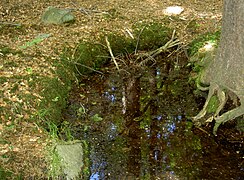
Mostecký potok spring

Headwaters of the Mostecký potok

Butterbur on Mostecký potok


Individual evidence
- ↑ http://mapire.eu/de/map/hkf_75e/?layers=osm%2C8&bbox=1403560.5999437456%2C6363511.592226155%2C1416220.4827534778%2C6368623.3184927255
- ↑ https://geoportal.bayern.de/bayernatlas/index.html?bgLayer=tk&X=5489178.23&Y=4548287.75&zoom=9&lang=de&topic=ba&catalogNodes=122
- ↑ Bavaria Atlas of the Bavarian State Government ( notes ) (roughly measured)
- ↑ Fritsch hiking map of the Northern Upper Palatinate Forest Nature Park, scale 1: 50,000