Kanaga Island
| Kanaga Island | ||
|---|---|---|
| Mount Kanaga | ||
| Waters | Pacific Ocean | |
| Archipelago | Aleutian Islands | |
| Geographical location | 51 ° 47 ′ N , 177 ° 15 ′ W | |
|
|
||
| length | 49 km | |
| width | 9 km | |
| surface | 480 km² | |
| Highest elevation | 1307 m | |
| Residents | uninhabited | |
Kanaga Island is an island in the Andreanof Islands , a group of islands in the southwest of the Aleutian Islands .
Description of the island
The uninhabited island, part of the US state of Alaska , has a land area of approximately 480 km², is 49 kilometers long and on average just under nine kilometers wide.
Mount Kanaga volcano
The northern part of the island is dominated by the 1307-meter-high active stratovolcano Mount Kanaga, which last erupted in 1995. In the south and east, a crescent-shaped ridge frames the volcano, which in turn is probably the remains of a former caldera . The found Dazite tuffs would also refer to this. Debris avalanche tracks that extend up to 30 kilometers into the sea have also been discovered. Various other shield and stratovolcanoes may have preceded them.
Bird colony
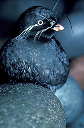
Kanaga Island is home to, among other things, a breeding colony of bearded reeds , the smallest alken bird after the dwarf balk . The breeding colony was only discovered in 1994 when a research vessel approached the island to investigate two lava fields.
Web links
- Alaska Volcano Observatory: Information on Mount Kanaga Volcano (English)
- Kanaga in the Global Volcanism Program of the Smithsonian Institution (English)


