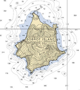
Bobrof Island
| Bobrof Island | ||
|---|---|---|
| NASA image of Bobrof Island | ||
| Waters | Pacific Ocean | |
| Archipelago | Aleutian Islands | |
| Geographical location | 51 ° 54 '22 " N , 177 ° 26' 47" W | |
|
|
||
| length | 4 km | |
| Highest elevation | 597 m | |
| Residents | uninhabited | |
| map | ||
Bobrof Island is a small uninhabited volcanic island of the Andreanof Islands , which belongs to the Aleutian Islands . The island is about 4 km long and lies between Kanaga Island and Tanaga Island .
Bobrof was first recorded in the nautical charts in 1852 by Mikhail Tebenkov as "Ostrov Bobrovoy Vilga", in English Otter Island .
The island consists mainly of the Bobrof volcano of the same name. This stratovolcano has in the past produced both explosive eruptions, which generated pyroclastic flows , mainly of andesite , as well as effusive eruptions. More precise information on its last eruptions cannot be given, but it is believed to be of modern origin.
Web links
Commons : Bobrof Island - Collection of Pictures, Videos and Audio Files
- Bobrof Island in the Geographic Names Information System of the United States Geological Survey
- Bobrof Iceland in the Global Volcanism Program of the Smithsonian Institution (English)
- Description of the volcano at the Alaska Volcano Observatory (English)
Individual evidence
- ↑ Bobrof Volcano description and information . English. Online at www.avo.alaska.edu, downloaded May 21, 2013.
- ↑ Global Volcanismo Program: Volcano Info . English. Online at www.volcano.si.edu, downloaded May 21, 2013.


