Mount Redoubt (Alaska)
| Mount Redoubt | ||
|---|---|---|
|
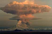
Northwest side of the volcano, 2009 |
||
| height | 3108 m | |
| location | Alaska , USA | |
| Mountains | Aleutian chain | |
| Coordinates | 60 ° 29 '7 " N , 152 ° 44' 35" W | |
|
|
||
| Type | Stratovolcano | |
| Last eruption | 2009 | |
| First ascent | 1959 by C. Deehr, J. Gardey, F. Kennell and G. Wescott | |
The Mount Redoubt is covered with glaciers, active Strato volcano with 3108 meters the highest mountain in the Aleutian Range . It is located 170 kilometers southwest of Anchorage in the Chigmit Mountains on the Alaska Peninsula on the Cook Inlet in Alaska and is part of Lake Clark National Park . The formation of the volcano began about 890,000 years ago.
outbreaks

Mighty eruptions occurred around 10,500 to 13,000 years ago and around 3500 years ago. The resulting rockfalls partly reached the Cook Inlet. Mount Redoubt erupted in 1881, 1902, 1966, 1989 and 2009. The eruption in 1989 created a 14,000 m high ash cloud. The ash covered an area of over 20,000 km².
On December 15, 1989, a Boeing 747-400 operated by KLM Royal Dutch Airlines was caught in this ash cloud at an altitude of 28,000 feet (approx. 8500 m) on its flight from Amsterdam Schiphol to Anchorage . As a result, all four engines failed for a short time, but after their restart, the flight to Anchorage could be continued.
- See also: KLM flight 867
1881
In 1881 there was apparently an eruption described as "in the east the volcano smokes constantly with periods of greater activity. Fire could be observed from the sea. A major eruption occurred in 1881 when a group of nature hunters halfway from Lava was caught by surprise and only two people escaped ". However, this outbreak has not been well documented by other sources.
1902
The volcano erupted fairly abruptly in 1902. He spat ashes from January 18-21 of that year. As a local newspaper described it: “It has just been reported that Redoubt, one of the volcanoes on Cook Inlet, erupted on January 18th, covering the land with ash and lava within 150 km. The news comes from Sunrise, but it is not clear if there was any damage as there were no boats in the vicinity of the volcano ” . There were other news reports about the eruption, one described it as follows: "There was a major earthquake that broke the mountain apart and left a large fissure," which may have described the volcanic crater cracking, but this is unlikely. It is said that flames erupted from the volcano's crater and the eruptions frightened locals in the area. Newspapers suspected that the ash made its way more than 150 km to the other side of Cook Inlet.
1989-1990
The volcano erupted on December 15, 1989. This lasted five months. Sudden melting of snow and ice on the summit by pyroclastic currents and a collapse of the dome caused lahars or mudslides to flow down the northern flank of the mountain. Much of the mudslides were in the direction of Cook Inlet, about 35 km from the volcano. Some lahars entered the nearby Drift River and it was feared that a nearby oil store could be destroyed.
2009
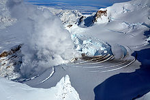
Volcanic activity was discovered on January 30, 2009, indicating a possible renewed eruption of the volcano. Among other things, a fumarole the size of two football fields and water running down the glacier formed in the glacier covering the volcano , which speaks for the rise of magma heat. On the night of March 22-23, 2009, Mount Redoubt erupted. An ash cloud reached an estimated height of 16,000 m. Ash precipitation was observed in the vicinity, population centers were not threatened. The Anchorage airport was repeatedly briefly closed.
The eruption continued with multiple lahars devastating the Drift River Valley below the mountain. They endangered an oil depot on the coast. The Chevron Corporation then stopped oil production in Cook Inlet . So far it has only been possible to bring some of the oil stocks stored there to safety. Parts of the Drift River Oil Terminal site were flooded by the lahars. The strongest outbreak so far occurred on April 4th. It reached the level of the strongest event of the 1989/90 eruptions. On this day, a new lava dome was observed in the summit crater of the mountain for the first time .
During the months of April and May, the mountain emitted gas widely and the lava dome slowly grew. The activity decreased in the course of June, the lava dome no longer grew significantly after it had reached a length of 1000 m. Alaska Volcano Observatory observers downgraded air traffic warnings on June 30. A year later, on April 12, 2010, after seismic activity had also calmed down, the mountain was declared calm.
Web links
- Mount Redoubt in the Global Volcanism Program of the Smithsonian Institution (English)
- Mount Redoubt Seismic Webicorders (seismic measurements of the last 24 hours)
- Mount Redoubt webcam (update frequency 10 minutes)
- Alaska Volcano Observatory (warning level and activity level)
- Mount Redoubt on Topozone
- News, photos and webcam of Mount Redoubt
Sources and Notes
- ^ AVO contributors: Event Specific Information: Redoubt - 1881 . Alaska Volcano Observatory. Retrieved December 1, 2008.
- ↑ Event Specific Information: Redoubt - 1902 . Alaska Volcano Observatory. Retrieved December 1, 2008.
- ↑ USGS contributors: 1989-90 Eruption of Redoubt Volcano, Alaska, and the First Test Case of a USGS Lahar Detection System . USGS . October 11, 2008. Retrieved November 30, 2008.
- ↑ a b Hole discovered in glacier volcano . Mirror online. Retrieved February 1, 2009.
- ↑ Alaska Volcano Observatory / USGS: Volcanic Activity Notice Mount Redoubt of March 22, 2009: 11:26 p.m. local time (20090322 / 0726Z)
- ↑ National Weather Service: Public Information Statement, March 23, 2009, 5:30 am local time ( memento of the original from March 27, 2009 in the Internet Archive ) Info: The archive link was inserted automatically and has not yet been checked. Please check the original and archive link according to the instructions and then remove this notice.
- ↑ Alaska Volcano Observatory: Mount Redoubt - Summary and Prognosis, April 11, 2009
- ↑ Alaska Volcano Observatory / USGS: AVO / USGS Volcanic Activity Notice of June 30, 2009: 10:21 am local time (20090630 / 1820Z)
- ↑ Alaska Volcano Observatory / USGS: AVO / USGS Volcanic Activity Notice of April 12, 2010: 12:10 local time (20100412 / 2010Z)


