Perger Au
As Pergerau or Perger Au once swampy landscape in the north was Machland south or southeast of Perg along the river arms and clots of Naarn and its coming from the northern hills inflows between Perg, Mitterskirchen and Baumgartenberg referred.
history
The Pergerau was first mentioned in a document in 1431. Accordingly, it was located between the villages of Zeitling and Mettensdorf . In the south it reached about the line where the great Naarn Canal runs today and to the Mettensdorfer Mühlbach. The northern border was formed by the former Hauderer Bezirksstraße or today's Bundesstraße 3 . The area is approximately 1,600 hectares and is traversed by the Naarn in the west and the Tobrabach in the east .
Originally it was pastureland . With the installation of weirs at the mills to better utilize the water power and the associated backwater, the Pergerau began to swamp around 1560.
The Naarn has a slight gradient in the plain. After the snow has melted on the granite plateau and after heavy rainfall, the water cannot drain away. It repeatedly floods large stretches of land, which dries up very slowly, mainly through evaporation of the water. The meadows are sour and devalued by poor harvest yields.
Naarn regulation in the 18th century
The Naarn floods mostly came very suddenly as a result of heavy downpours in the hinterland or prolonged rain. The meadows and fields on both sides of the Naarn then mostly resembled a lake. The years 1118, 1126, 1172, 1193, 1195, 1210, 1404, 1406, 1436, 1490, 1509, 1520, 1527, 1570, 1572, 1573, 1597, 1598, 1606, 1617, 1647, 1651, 1658 were used as flood years , 1670, 1672, 1677, 1682, 1705, 1716, 1736, 1770, 1771, 1775 and 1778.
According to a report by the governor of July 7, 1769 about the poor conditions in the Pergerau and after speaking to Empress Maria Theresa , she took a series of measures. On the one hand the elimination of the many bends in the Naarn by the neighboring subjects, on the other hand the permanent clearing of the river bed from the flood failure by the wood flooding company and on the other hand the construction of two canals.
With the dispatch of commissions that met from April 7, 1776 in Perg, the desummation of the Pergerau was tackled. The swampy soil was drained by 110 Bohemian pond graves, local day laborers, carpenters and water carriers from the Machlandes . The canals built under the Perger market judge and brewer Josef Frieß were already completed in 1776 (small Naarn Canal with Tobra Canal) and 1777 (large Naarn Canal).
The larger, the actual Naarn Canal, ran from Perg towards Mitterkirchen and was 4,086 long, the smaller one led from the Schöberl factory ( Kickenau ) in the direction of Baumgartenberg. This small canal was called the Maria Theresien Canal and was 7455 m long. Its task was to take in the Thurhofbach and the other waters coming from the northern slopes. The drained land was divided into strips among the municipal houses and the areas concerned were called house meadows . They were not allowed to be sold and remained with the respective house when they were used.
The completed work was rendered ineffective by the lack of ongoing evacuation and the rebuilding or elevation of the Haidmühl weir and other dams and the Pergerau swamped again. A little later, the heavy sand debris filled the canals and in 1830 dams had to be built on both sides of the great canal. The fields of the Machland adjacent to the meadows also suffered from the wetness. It is recorded that in the past the grain almonds were placed on bridges to protect them from moisture or flooding.
Therefore, the record of flood years continues: 1784 , 1785, 1786, 1787, 1799, 1809, 1813, 1815, 1819, 1820, 1824, 1829, 1833, 1840, 1850, 1853, 1862, 1876, 1880, 1883, 1890 , 1892, 1896, 1899, 1909, 1910, 1912, 1914, 1917, 1929, 1932 and 1954.
Naarn regulation in the 20th century
Later there were several plans for a new regulation of the Naarn in Machland, only in 1926 was a plan ready for construction. The start of construction work was delayed due to the unfavorable economic situation. Not until 1938 did the labor service tackle the project with local workers. Labor camps were set up in Perg, Arbing , Baumgartenberg and Kirchstetten, and work had to be stopped in 1942. After 1945, the inhabitants of the Machland made new demands for the area to be drained.
Almost two centuries after the first regulation, the Machland water association was able to carry out the water management rehabilitation with funds from the federal government and the state of Upper Austria, a new regulation of the Naarn (from 1968 to 1972). The cost was estimated at 64 million schillings. The landowners affected also had to make appropriate contributions from interested parties in relation to the expected success. At that time the Alte Naarn was converted into a canal. The groundwater level was lowered by around 1.4 m and large areas were drained or made workable.
In 1967 the clearing of the Naarn bed downstream from Perg had started and the bed load from the river bed remained on both sides of the bank as a dam to protect against flooding. It was only at this stage that the Upper Austrian Provincial Government commissioned a water management study for the Machland , which later formed the basis on the one hand for draining the Machland and on the other hand for creating flood protection .
The Machland river regulation comprised, on the one hand, the flood regulation sections of the Naarn from Perg downstream via Wagra and Labing to the Hüttinger Arm of the Danube (about 10.5 km), and on the other hand the regulation of the tributaries Zeitlingerbach, Thurnhofbach, Auhofbach, Tobrabach (with a flood transfer basin to the Naarn river ) and Arbingerbach.
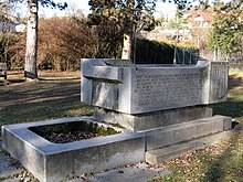
A fountain made of granite stones by Radler-Wöss is located in Seyrpark and with its inscriptions reminds of the Naarn regulations of the 18th and 20th centuries.
Effects of Naarn Regulation
The Naarn regulations (in addition to the effects of the power plant construction in Mitterkirchen / Wallsee and the river power plants along the Naarn) had significant effects on the flora, fauna and bird life as well as the fishing industry in the Machland in the Naarn and in the adjacent landscapes such as the Perger Au .
For example, after the Naarn regulation, 200 liters of water per second remained in the Schwemmnaarn. The sight of the originally large river bed and the small trickle was accordingly bleak. Through the efforts of those authorized to fish and their managers, or through the understanding of the Machland Water Association, a weir was built near the Labinger Bridge in the municipality of Mitterkirchen, which drains at least 400 liters of water per second into the Schwemmnaarn. This enabled the Schwemmnaarn to be made a manageable body of water again.
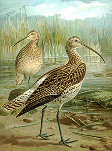
Before the new Naarn regulation, the Perger Au was a large meadow area and thus the prerequisite for the formerly largest Upper Austrian curlew population to be found there. In 1980 only a meager remnant was left of it. The white storks were not impressed by the changed ecological conditions.
literature
- Florian Eibensteiner, Konrad Eibensteiner: Das Heimatbuch von Perg, Upper Austria, self-published, Linz 1933.
- Georg Grüll : The Naarn regulation and drainage of the Pergerau. In: Communications from the Upper Austrian Provincial Archives. Linz 1961.
- Ernst Neweklowsky: The Naarn flood. In: Upper Austrian homeland sheets. Year 16, Issue 2, April to June 1962, Linz 1962, online (PDF) in the OoeGeschichte.at forum
- Federal Administration and Office of Upper Austria. State government, press department (ed.), Festschrift Naarnregulierung. Linz 1968.
- Rudolf Zach : Perg in the mirror of history. In: Stadtgemeinde Perg (Hrsg.): Perg, Festschrift on the occasion of the city survey 1969. Linz 1969
- Association for the publication of a district homeland book Perg: Municipalities of the district Perg. Linz 1995.
- Franz Asanger : Mitterkirchen - a historical portrait of the Machland community. Published by: Marktgemeinde Mitterkirchen im Machland, Mitterkirchen 1999
Web links
- Map to the room unit
- Guiding principles for nature and landscape
- Interesting facts about the nature of the Machland can be found at www.entenlacke.at
Individual evidence
- ^ Franz Asanger: Mitterkirchen - a historical portrait of the Machland community . Ed .: Marktgemeinde Mitterkirchen im Machland. Mitterkirchen 1999, p. 132 ff .
- ^ Franz Asanger: Mitterkirchen - a historical portrait of the Machland community . Ed .: Marktgemeinde Mitterkirchen im Machland. Mitterkirchen 1999, p. 151 f .
- ^ Franz Asanger: Mitterkirchen - a historical portrait of the Machland community . Ed .: Marktgemeinde Mitterkirchen im Machland. Mitterkirchen 1999, p. 352 ff .


