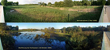
Nature reserve biotope network Spreeaue
The Spreeaue Biotope Association is a 634.54 hectare nature reserve in Brandenburg that has been under nature protection since June 25, 2003 .
prehistory
Before 1900, the Spreeaue was a landscape in this area that was regularly inundated by strongly fluctuating water levels in the Spree. Between marshy areas, wet meadows, alluvial forests and many smaller tributaries of the Spree, a diverse, sometimes unique fauna and flora was found - comparable to parts of the Spreewald. The affected areas of the Spreeaue north of Cottbus have been increasingly drained by amelioration since the 17th century and diked near the river around 1900. Through these measures, tributaries of the Spree were cut off and land was gained for agriculture. Industrial agriculture until the late eighties of the 20th century caused a partial over-fertilization of the fields, with further consequences also for the diked remaining natural areas of the Spreeaue. The result was a lower biodiversity in flora and fauna.
With the partial decline of agriculture from 1990 in Lusatia, opportunities arose to correct this development. The project "Renaturation of the northern Cottbuser Spree" was accelerated by the preparation of the devastation of the Lakoma village and the Lakoma pond landscape for the Cottbus-Nord opencast mine by the energy company Vattenfall . The Lakoma pond landscape ( red-bellied toads , hermits, etc.) should "move" to the Spreeaue. The area was added to the list of nature reserves in Brandenburg under the term “Biotope Association Spreeaue” . It was decided to renaturalize a 10-kilometer section of the Spree north of Cottbus. The range of planned measures ranged from the construction of new ponds to the partial meandering of the Spree, the creation of new branches of the Spree, revitalization of the wet meadows by lowering the banks, revitalization of the remains of the Spreeau forests, construction of rapids to the expansion of the Spreeau by a more generous dike near Fehrow.
Start of construction work
After a long and complicated planning phase, the first work on the southern bank of the Spree near Maiberg , a residential area in Cottbus, became visible in 2007 . The shell of the future ponds was built to compensate for the Lakoma ponds. Huge masses of earth were excavated, moved and biologically enriched. A total of 25,000 woody plants were planted in the area surrounding the new pond landscape, including 16,450 trees and bushes, 550 willow and black alder rhizomes that can be harvested again, and more than 8,000 willow cuttings and sticks. In order to enable a quick start of the biological processes, about 6,000 m³ of rhizome material (from reeds) was installed. In the summer of 2007 and 2008, 97,000 amphibian larvae and young animals, 55,000 of which were red-bellied toads, were relocated from the Lakoma pond area to the Spreeaue - an action that has been seldom seen so far, especially in terms of size. The Spreeaue near Maiberg has been used by organic farmers since 2007. The maintenance of the landscape was partly done by Heck cattle and water buffalo , who do their duty in their own reserve.
In 2008 hydraulic engineering changes (meander formation and bank subsidence) took place mainly in the vicinity of the Maiberger Spreebogen. Around 200 meters of new water were constructed for the meander connection and around 400 meters of water development in the area of the meander loop. Furthermore, two overflow dams and three ground sills were built. The restructuring of the Spree to a length of 2.9 kilometers southwest of the Maiberger Spreebogen also falls during this period.
Although the environmental construction site still looked quite virgin, public interest increased by leaps and bounds. While Lusatia was previously a synonym for excavated landscapes of no value, the transformation of a landscape into a showcase project over a few years could be observed here. By the halfway point of the construction work alone there were 8,000 guided visitors, some of them experts from all over the world. The direct location on the Gurken Cycle Path to the Spreewald brought a multiple of the latter number of visitors.
Halftime
At the end of October 2009, halfway through the long-term construction work, new figures were presented. Thereafter, a total of 150,000 amphibians were moved and 80,000 shrubs and woody plants were planted. 40 Heck cattle , Tarpan image breeds and water buffalo were introduced. The area is to be closely monitored by means of extensive monitoring by 2017.
The 2010 flood
At the beginning of August 2010 it rained heavily in Central Europe. The consequences were to be experienced in the form of floods in the area of the Lusatian rivers. For the first time in almost a century, the renatured Spree floodplain acted as a huge catchment basin for part of the water masses. The first flood wave on August 10th (apex) put large floodplains under water. The dikes held. The second flood wave in October 2010 was less violent, but optically looked even worse, as the ground was still completely sodden and the water therefore formed even larger lakes within the dykes. The temporary lakes attracted hundreds of water birds. For example, 122 unusual swans were counted between the Cottbus district of Döbbrick and Maiberger Brücke on October 18, 2010 (around 5 p.m.). In addition to these positive consequences, there are also very negative consequences for the people living in the Spreeau. Hundreds of houses have been standing in the soaked area for months, cellars are full of water and the pastures cannot be used for agriculture. The renaturation measures of the Spree are increasing the risk of flooding due to increased rainfall.
See also
Web links
- Ordinance on the nature reserve "Biotopverbund Spreeau" of May 21, 2003
- Construction of the new pond landscape
- Relocation of amphibians
- Meandering Spree
- Construction phase IV structuring of the Spree
Coordinates: 51 ° 50 ′ 56.3 " N , 14 ° 18 ′ 31.9" E


