
Neratov v Orlických horách
| Neratov | |||||
|---|---|---|---|---|---|
|
|||||
| Basic data | |||||
| State : |
|
||||
| Region : | Královéhradecký kraj | ||||
| District : | Rychnov nad Kněžnou | ||||
| Municipality : | Bartošovice v Orlických horách | ||||
| Geographic location : | 50 ° 13 ' N , 16 ° 33' E | ||||
| Height: | 620 m nm | ||||
| Residents : | |||||
| traffic | |||||
| Street: | Bartošovice v Orlických horách - Orlické Záhoří | ||||


Neratov (German Bärnwald ) is a locality of the municipality Bartošovice v Orlických horách in Okres Rychnov nad Kněžnou in the Czech Republic.
geography
The village is located five kilometers north of Bartošovice v Orlických horách on the eastern slope of the Eagle Mountains at the foot of the Anenský vrch in a small side valley of the Erlitz directly on the state border with Poland.
Neighboring settlements are Podlesí and Rudawa in the north, Poniatów in the northeast, Gniewoszów in the southeast, Vrchní Orlice in the south, Hadinec in the southwest, Říčky v Orlických horách in the west and Nová Ves in the northwest.
history
The present Neratov was founded around the middle of the 16th century by Jan Licek von Riesenburg (Lickové z Rýzmburka) , the owner of the Rokitnitz rule , and settled with Germans from the neighboring county of Glatz , who named it Bärnwald.
After the Munich Agreement , the place was added to the German Reich and until 1945 belonged to the district of Grulich , administrative district of Troppau , in the Reichsgau Sudetenland .
After the end of World War II, the Germans were expelled in 1945/46 . Today Neratov has few permanent residents.
Due to its location in the Eagle Mountains, the village is a recreational area, especially for Prague residents, who bought ownership of around 100 historic houses after 1945.
Demographics
| year | Residents | Remarks |
|---|---|---|
| 1930 | 378 | |
| 1939 | 353 |
Church of the Assumption
The foundation stone for the construction of the baroque Church of the Assumption was laid on August 14, 1723 by Johann Karl von Nostitz . The plans for the church are said to come from Giovanni Battista Alliprandi , who died in 1720 . After completion of the building, Bärnwald developed into an important place of pilgrimage. The special thing about this sacred building is the north-south orientation, which is unique in Europe. During the Second World War, the church was shot at with a bazooka of the Red Army on May 10, 1945 and burned down. The ruins later fell into disrepair and was demolished.
After the Velvet Revolution , the building was rebuilt in the 1990s with German financial support. Every year in August, Assumption celebrations are held in the church, to which many guests from abroad make pilgrimages. A new church roof was completed for the Assumption Day 2007. This has a special cross shape made of glass that spans the nave so that the sky remains visible.
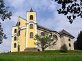
Church of the Assumption

The church from the northwest

Church room with a new glass roof

Cemetery with chapel


Individual evidence
- ↑ Jaroslav Sula: Rokytnice v Orlických Horách a Mauschwitzové of Armenruh. Oftis, Ústí nad Orlicí 2010, ISBN 978-80-7405-086-2 .
- ↑ a b Michael Rademacher: German administrative history from the unification of the empire in 1871 to the reunification in 1990. Grulich district. (Online material for the dissertation, Osnabrück 2006).
- ↑ Rychnovský deník: Neratov možná dostane varhany
- ↑ Information from the church, there this is described; but also personally reported by eyewitnesses at a meeting of the expellees on July 24, 2014 during the Annawochen in Rokitnitz (the Red Army did not have tanks in the Eagle Mountains at that time!) PDF: additional source at baernwald.de
Web links
- Neratov locality website
- Bärnwald on the website of the Adlergebirgsverein and the corresponding wiki
- Website about Bärnwald