
Říčky v Orlických horách
| Říčky v Orlických horách | |||||
|---|---|---|---|---|---|
|
|||||
| Basic data | |||||
| State : |
|
||||
| Region : | Královéhradecký kraj | ||||
| District : | Rychnov nad Kněžnou | ||||
| Area : | 1480 ha | ||||
| Geographic location : | 50 ° 13 ' N , 16 ° 28' E | ||||
| Height: | 635 m nm | ||||
| Residents : | 92 (Jan 1, 2019) | ||||
| Postal code : | 517 61 | ||||
| traffic | |||||
| Street: | Rokytnice v Orlických horách - Zdobnice | ||||
| structure | |||||
| Status: | local community | ||||
| Districts: | 1 | ||||
| administration | |||||
| Mayor : | Josef Peterka (as of 2007) | ||||
| Address: | Říčky v Orlických horách 2 517 61 Rokytnice v Orlických horách |
||||
| Municipality number: | 576735 | ||||
| Website : | www.obecricky.cz | ||||


Říčky v Orlických horách (German Ritschka ) is a municipality in the Czech Republic . It is located 14 kilometers northeast of Rychnov nad Kněžnou in the Eagle Mountains and belongs to the Okres Rychnov nad Kněžnou .
geography
The scattered settlement lies below the main ridge in the southern part of the Eagle Mountains and spreads in the valley of the Říčka ( Klause ) with six tributaries. To the north rises the 990 meter high Zaklety , on the slopes of which several ski lifts have been built. To the northeast lie the Komáří vrch (992 m) and to the east the Mezivrší (939 m) and the Anenský vrch (991 m).
Neighboring towns are Orlické Záhoří and Nová Ves in the northeast, Neratov in the east, Horní Rokytnice in the southeast, Rokytnice in the south, Nebeská Rybná in the southwest, Pustiny and Souvlastní in the west and Rysé and Zdobnice in the northwest.
history
The village was first mentioned in a document in 1577 together with Zdobnice in a deed of purchase for both villages and the surrounding forests deposited at the Kuttenberg Mint . At the beginning of the 17th century, Rokytnice was the starting point for further settlement (with Germans) of the forest areas below the ridge. In addition to forestry, mining for iron ore and lead as well as gold was carried out at this time. Johann Nicolaus von Nostitz brought German settlers from Westphalia , the Haberner Land and the County of Glatz to the area. In 1609 forest workers were brought in from the Giant Mountains to manage the forest areas .
1703 Leopold I. sold Říčky and Zdobnice including the forests to Norbert von Kolowrat . Until the opening of their own school in 1785, the children went to Himmlisch Rybnai for lessons. The parish was also there. The church was built between 1790 and 1792. In 1808 the new three-class school began teaching. In 1855 the branch church in Ritschka was elevated to a parish church. In 1860 the village in the Senftenberg district administration consisted of 183 calipers and properties.
The new road from Rokytnice v Orlických horách to Zdobnice was built in 1906; In 1913 the construction of the road from Rokytnice over the mountain ridge to Schwarzwasser and Kronstadt was finished. In 1934 the municipal council decided to rename Říčky in Ritschka . Between 1935 and 1938 bunker lines for the Czechoslovak Wall were built on the ridge of the Eagle Mountains ; the chapel of St. Anna including the statues and the crucifix was moved from Ernestinenberg to the Hadinec forester's house. After the Munich Agreement , the place was incorporated into the German Empire as part of the Grulich district. In 1939 Ritschka had 873 inhabitants. After the Second World War, the German residents were expelled; in 1947 the population was reduced from 517 to 437. The vacant properties were handed over to Volhynientschechen, but they emigrated again.
Since the 1950s, Říčky became more and more of a holiday village and in 1955 only had 66 permanent residents. In 1954 the village was visited by over 1,300 holiday guests, in 1946 there were only half as many. In 1975 the place was incorporated into Rokytnice and the school was closed in the same year. Říčky had 113 inhabitants at that time. In 1990 the place regained its independence.
Community structure
No districts are shown for the municipality of Říčky v Orlických horách. The localities of Pustiny ( desert ) and Rysé ( giant ) belong to the municipality .
Attractions
- Church of the Holy Trinity, built 1790–1792
photos
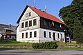
The local authority

The farmhouse

