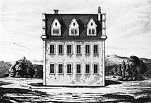
New hunting lodge Jägersburg
The (new) hunting lodge Jägersburg , also called Parforcehaus , was a small hunting lodge built in the 18th century in the Jägersburg Forest near Groß-Rohrheim and Einhausen (Hesse) . It is to be distinguished from the (first) hunting lodge Jägersburg , which was built nearby in the 17th century. The building became particularly important as the place where Landgrave Ernst Ludwig died in 1739.
location
About one kilometer northwest of the first hunting lodge, on the north-western boundary of the Jägersburger Forest, the Jägersburg chief forester, consisting of the forester's house and a few outbuildings.
This place, now marked as Jägersburg on maps, is now located directly on the border between the communities of Einhausen and Groß-Rohrheim, at the Jägersburg junction , where the L3261 Biblis - Bensheim-Langwaden road branches off from the L3111 Einhausen - Groß-Rohrheim.
The new hunting lodge Jägersburg, also known as the Parforcehaus, was no longer built in the middle of the forest like its predecessor, but directly opposite this head forester's office. The location is now immediately east of the L3111 and north of the L3261. The former castle moat now forms the boundary between Groß-Rohrheim and Einhausen in such a way that the location of the castle is in Groß-Rohrheim area.
history
In 1713 the hunting lodge was built on behalf of Landgrave Ernst Ludwig. The building had two stories and a rectangular plan. It was no longer round like its predecessor, because it should not be possible to shoot game in all directions directly from the building, as was the case with the first hunting lodge. Rather, it served as a place to stay and a meeting point before and after the hunt, which was now mainly carried out on horseback as a parforce hunt . The location right next to the forest ranger's office and on the road brought with it significant logistical advantages, in contrast to the location of the old castle in the middle of the forest. From here, the hunting enthusiast Landgrave and his guests organized numerous hunts in the Jägersburger Forest. Ernst-Ludwig stayed here in the last days of his life and finally died in the castle on September 12, 1739.
While hunting still flourished under his successor Ludwig VIII (1691–1768), the means for this were under Louis IX. (1719–1790) drastically reduced due to financial difficulties of the landgraviate. As a result, hunting became increasingly less important. So the reports about the castle in the late 18th century are lost. Its exact end is not known.
Then, instead of hunting, the valuable wood in the Jägersburger Wald became more and more the focus of the landgraves' attention, so that the Jägersburg chief forester remained important for many years.
present
Today the location of the building has grown over and only the outline of the hexagonal moat that once surrounded the hunting lodge can be seen.
On the opposite side of the road, however, there are still buildings of the former head forester's office. Today these are used as the Landgasthaus Forsthaus Jägersburg , as a residential building and still as the Jägersburg district forester of the Hesse Forest .
The place name Jägersburg has been preserved over the centuries and is mainly used today for the buildings and the crossroads in the area of the former forest ranger's office. The waterworks of the Riedgruppe Ost water supply association, a few hundred meters to the east, is therefore also known as the Jägersburg waterworks .
literature
- Rudolf Kunz: Hunting in the Jägersburger Forest , In: Paul Schnitzer, Franz Hartnagel, Günther Janowitz (Red.); Community Board Einhausen (ed.): Festschrift 1200-year celebration Einhausen , 1968
Individual evidence
- ^ Community of Groß-Rohrheim: Land use plan of the community of Groß-Rohrheim. (PDF 2.72 MB) As of March 2006. In: Bürger-GIS Bergstrasse district. Bergstrasse district, accessed on August 5, 2011 .
Coordinates: 49 ° 42 ′ 17.9 " N , 8 ° 30 ′ 41.5" E


