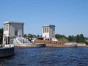
Gorkier Reservoir
| Gorkier Reservoir Горьковское водохранилище |
|||||||||
|---|---|---|---|---|---|---|---|---|---|
|
|||||||||
|
|
|||||||||
| Coordinates | 56 ° 55 '9 " N , 43 ° 14' 46" E | ||||||||
| Data on the structure | |||||||||
| Construction time: | 1948-1956 | ||||||||
| Power plant output: | 520 MW | ||||||||
| Data on the reservoir | |||||||||
| Altitude (at congestion destination ) | 84 m | ||||||||
| Water surface | 1 590 km² | ||||||||
| Storage space | 8th 710 000 000 m³ | ||||||||
| Catchment area | 229 000 km² | ||||||||
The Gorkier reservoir ( Russian Горьковское водохранилище / Gorkowskoje wodochranilishche ) is a reservoir on the Volga in Russia ( Europe ). It is part of the so-called Volga-Kama Cascade .
The reservoir is located northwest of the megacity Nizhny Novgorod and around 360 km northeast of Moscow . Its maximum storage volume is 8.71 billion m³ over an area of 1,590 km². The Nizhny Novgorod hydropower plant ( ⊙ ) has an installed capacity of 520 MW .
Construction of the total of over 13 km long shut-off (mostly Dam , in the area of hydropower station gravity dam ) was 1948. The units of the power plant went into operation 1955-1956; the flooding of the reservoir lasted from 1955 to 1957.
literature
- A. Gorkin and others: Geografija Rossii: Enziklopeditscheski slowar . Bolschaja Rossijskaja enziklopedija, Moscow 1997, ISBN 5-85270-276-5 , p. 148. (Russian)
Web links
Commons : Gorkier Reservoir - Collection of images, videos and audio files
Individual evidence
- ↑ Article Gorkier Reservoir in the Great Soviet Encyclopedia (BSE) , 3rd edition 1969–1978 (Russian)
- ↑ Gorkier Reservoir in the State Water Register of the Russian Federation (Russian)

