Nordstadt (Braunschweig)
| District of Nordstadt |
|
|---|---|
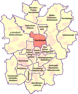
 Location of the Nordstadt district (red) |
|
| District Mayor: | Angela Marten (SPD) |
| District: | No. 331 |
| Residents: | 22,117 (Dec. 31, 2017) |
| Surface: | 6.61 km² |
| Population density: | 3,296 inhabitants per km² |
| Postcodes: | 38106 |
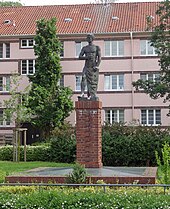
 Old building of the TU Braunschweig |
|
The northern city is one of 19 municipalities of Braunschweig . He has the official number 331 . The district has around 22,200 inhabitants with an area of 661 hectares and thus 3.4 percent of the total area of Braunschweig (as of December 31, 2012, statistics from the city of Braunschweig). It includes the statistical districts 06 Altes Hochschulviertel , 16 Nordbahnhof , 17 Neues Hochschulviertel , 37 Schwarzer Berg and 43 Siegfriedviertel .
geography
The city district is largely bounded in the west and south by the Oker or Okerumflutgraben and in the east and north by the railway lines to Gifhorn and Watenbüttel . Part of the border in the northwest is a section of the BAB 391 . In the southeast, the Botanical Garden , Hagenring and Hans-Sommer-Straße form the border.
The northern part of the city has no uniform development. Rather, it consists of sub-areas that were gradually built for different reasons.
City quarters and districts
Northern ring area
The area described here includes the area of urban expansion or the expansion of the city into the outer city from the middle of the 19th century. First of all, buildings were built on the arteries, which are listed in the Braunschweig address book, which was first published in 1860.
According to old maps, the areas within the Wilhelminischer Ring consisted largely of the glacis and gardens as well as the Paradeplatz (later the small parade ground) until the city was expanded (from approx. 1850 ).
From 1860, with the introduction of the address book, the development of the Bültenweg arterial roads (1860: way to Bülten , evidence on a historical map from 1753/54) and the Hamburger Straße, which was already used as a trade and military route in the Middle Ages, can be determined. But also the "Hasenwinkel" (or "Im Hasenwinkel"), the later "Rebenring" (1874 "Rebenstrasse", 1860 "Am Kleinen Exerzierplatze" or "Weg nach dem Kleiner Exerzierplatze") and "Am Bülten" are in the first address book of the City of Braunschweig mentioned.
In 1877 the Technical University (today Braunschweig Technical University ) was rebuilt on the Neue Promenade (today Pockelsstrasse ). In the surrounding area " a residential area for high demands developed between Hamburger Straße (today Mühlenpfordtstraße ) and Bültenweg". Most of these buildings are still preserved today.
service
In the last quarter of the 19th century, several service companies for the city of Braunschweig were established between Bültenweg and Oker, especially north of the Wilhelminischer Ring:
- In 1888 the second municipal gas works was built on Taubenstrasse, in 1959 the gas works switched from its own supply to long-distance gas from Salzgitter, and from around 1963 the new central warehouse of the municipal works was built here.
- The North Station was built as part of the construction of the Ringbahn or State Railroad (1886), with Geysostraße being the entrance.
- In 1879 the municipal slaughterhouse was built between Hamburger Straße and Mittelweg, which was relocated to Hansestraße in 1977. The Braunschweiger Zeitung moved from the city center to this site in 1981.
- At the corner of Mittelweg and Ludwigstrasse, the Viktoria-Luise-Haus (state, mother and baby home) was inaugurated in 1918, which developed into a children's clinic and moved to Holwedestrasse around 1960. In 1963, Lebenshilfe took over the building.
- The municipal building yard is also located on Ludwigstrasse.
- The Uferstraße thermal power station is located on Uferstraße, the history of which as an electricity plant dates back to the beginning of the 20th century.
- From 1901 the nurses and hospital "Red Cross" (since 1974 municipal health department) is located on Hamburger Strasse on the edge of the Siegfriedviertel.
- The institute for the deaf and dumb was located on today's Katharinenstraße from 1828 to 1891, then moved to the Charlottenhöhe (see Viewegsgarten-Bebelhof ).
- The children's home "Elisabeth", which was part of the Jewish Foundation at the time, is located on Mittelweg from 1908 onwards.
- The Schützenhaus and Schützenplatz are moved here from Maschplatz in 1890.
- The municipal disinfection facility was rebuilt in 1908 on Totentwete (today Mitgaustraße).
Gardens, cemeteries
The botanical garden has been located in the south of the area since 1840 .
Cemeteries were relocated to what would later become the outer city earlier. On Friedhofsgasse (1873 Friedhofsstraße, 1893 Katharinenstraße, verifiably 1753/54) the Katharinenfriedhof has been located since 1706 and the garrison cemetery since 1713. On Hamburger Straße from 1802 to 1898 the cemetery of the St. Andreas community and from 1797 to 1910 the old cemetery of the Jewish community .
The Ratsbleiche or Kattunbleiche, which was still in operation in the 19th century and is reminiscent of a street name today (since 1911), deserves at least a limited mention.
Black Mountain
The Black Mountain is a district that emerged as a settlement in the 1960s. The name is said to come from the dark pines that stood on the 73 m (above sea level) "high mountain". This elevation extends over the fields of Großer and Kleiner Jahnskamp.
From 1932 the area of the already existing street Am Schwarzen Berge with its cross streets Jahnskamp, Stadtblick and Heimgarten was built on. The area, on which there were only allotments at the time, only belonged to Braunschweig when it was incorporated on April 1, 1934. At the time, only private clients were building on the site, and hardly any guidelines were given for the development.
Siegfriedviertel
The Siegfriedviertel district emerged as a modern green estate in the 1920s, 1930s and 1940s. The name of the quarter and the street names are based on the Nibelung saga about Siegfried the dragon slayer. In addition to multi-family apartment blocks, private homes were also built here. North of the Siegfriedviertel on Dowesee is the school and community garden , which was created in 1919 under the name Hauptschulgarten.
University district
The site was initially intended for the Wilhelminian expansion of Braunschweig. However, there was no longer any development on the area, partly as a result of the decreasing interest in new building areas.
After the end of the Second World War, the new main street "Hans-Sommer-Straße" was built, which should relieve the Gliesmaroder Straße. A large number of new buildings for the Technical University of Braunschweig were built on the street .
"Northern ring area" residential area
The administration plans to build a new residential quarter with approx. 1000 residential units in the areas between Taubenstrasse and Wodanstrasse. In the first phase of construction, from 2016, the partner Nibelungen Wohnbau GmbH, the reconstruction building cooperative and the Braunschweiger building cooperative will build approx. 530 apartments exclusively in multi-storey buildings north of Taubenstrasse. In a second construction phase, approx. 500 apartments follow.
In the "BZ-Areal" construction area between Hamburger Straße and Mittelweg, a private investor would like to build up to 500 residential units in addition to a large local supplier. Here, too, primarily apartments in multi-storey buildings are to be built; however, there are also a few single-family houses planned.
The third area to be developed is an area north of Ludwigstrasse. Up to 200 additional residential units could be built here.
traffic
The Nordstadt district is connected by numerous bus and tram lines. The most important connection point in the network is the “Hamburger Straße” stop. There are travel options to the city center, the ring area and the northern part of the city.
literature
- Jürgen Hodemacher : Braunschweig's streets - their names and their history. Volume 3: Outside the city ring. Meyer, Braunschweig 2002, ISBN 3-926701-48-X .
- Otto Hahne : Old individual farms in the city of Braunschweig. In: Research on Brunswick history and linguistics. 1954, pp. 55-73. (ADBB; Brochure I 25.078)
- Otto Hahne: Brunswick village names explained from the locality. In: Braunschweiger Blätter. 1937, F. 5, pp. 8-15. (ADBB; Brochure I 3805)
- Norman-Mathias Pingel: City expansion and municipal authorities in Braunschweig 1851-1914. Hahn, Hannover 1998, ISBN 3-7752-5799-3 .
Web links
- District council 331 Nordstadt on braunschweig.de
Individual evidence
- ↑ District 331 Nordstadt ( Memento of the original from July 22, 2011 in the Internet Archive ) Info: The archive link was automatically inserted and not yet checked. Please check the original and archive link according to the instructions and then remove this notice. on braunschweig.de.
- ↑ a b Population statistics on braunschweig.de, accessed on July 29, 2018.
- ↑ Braunschweig in Statistics 2010, p. 20. (PDF; 8.4 MB).
- ^ City of Braunschweig (ed.): Historical atlas of the city of Braunschweig. Braunschweig 1958–71, (Hist. Atlas I) sheet 51.
- ^ Norman-Mathias Pingel: City expansion and municipal authorities in Braunschweig 1851-1914 (= Braunschweiger Werkstücke. Series A, No. 45). Hahn, Hannover 1998, ISBN 3-7752-5799-3 , p. 34.
- ↑ hist. Atlas I, 53.
Coordinates: 52 ° 17 ' N , 10 ° 31' E
