
Northwest Arkansas Regional Airport
| Northwest Arkansas Regional Airport | |
|---|---|

|
|
| Characteristics | |
| ICAO code | KXNA |
| IATA code | XNA |
| Coordinates | |
| Height above MSL | 392 m (1286 ft ) |
| Transport links | |
| Distance from the city center | 13 km southwest of Bentonville , 17 km southwest of Rogers , 18 km northwest of Springdale |
| Street | AR 12 / AR 264 |
| Basic data | |
| opening | November 1, 1998 |
| operator | Northwest Arkansas Regional Airport Authority |
| surface | 884 ha |
| Terminals | 1 |
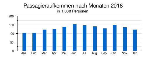
| Passengers | 1,574,610 (2018) |
| Air freight | 34 t (2018) |
| Flight movements |
44,370 (2018) |
| Start-and runway | |
| 16/34 | 2682 m × 46 m concrete |
The Northwest Arkansas Regional Airport is a regional airport in the US state of Arkansas , the Fayetteville-Springdale-Rogers Metropolitan Area served. A large part of the traffic is caused by the headquarters of the Walmart group in Bentonville .
Location and transport links
Northwest Arkansas Regional Airport is eight miles southwest of downtown Bentonville, 10 miles southwest of downtown Rogers , 11 miles northwest of downtown Springdale and 17 miles northwest of downtown Fayetteville . It is located in the area of the village of Highfill. Arkansas State Route 12 runs north of the airport and Arkansas State Route 264 runs south of the airport . The closest interstate is Interstate 49 , which runs a few miles east. Northwest Arkansas Regional Airport is not part of the local public transport system, and passengers have to use rental cars, taxis and similar offers.
history
The airport was opened on November 1, 1998 as a replacement for Fayetteville Airport, whose capacity was no longer sufficient.
Airlines and Destinations
Northwest Arkansas Regional Airport is used by Allegiant Air , American Airlines / American Eagle , Delta Air Lines / Delta Connection, and United Express . Only destinations in the United States are served, including in particular the hubs of the individual airlines.
Traffic figures

| year | Passenger volume | Air freight ( tons ) (with airmail ) |
Aircraft movements (with military) |
|---|---|---|---|
| 2018 | 1,574,610 | 34 | 44,370 |
| 2017 | 1,438,922 | 46 | 46,740 |
| 2016 | 1,396,738 | 76 | 41,676 |
| 2015 | 1,295,235 | 68 | 38,421 |
| 2014 | 1,276,851 | 51 | 39,695 |
| 2013 | 1,160,032 | 39 | 40,810 |
| 2012 | 1,135,023 | 25th | 43,609 |
| 2011 | 1,127,909 | 27 | 42,414 |
| 2010 | 1,139,801 | 44 | 44,960 |
| 2009 | 1,083,638 | 89 | 44,568 |
| 2008 | 1,146,954 | 115 | 47,975 |
| 2007 | 1,200,122 | 104 | 55.193 |
| 2006 | 1,172,049 | 74 | 53,522 |
| 2005 | 1,168,858 | 135 | 55.091 |
| 2004 | 1,018,481 | 158 | 49,378 |
| 2003 | 892.489 | 149 | 44,259 |
| 2002 | 786.948 | 169 | 36,653 |
| 2001 | 743.822 | 162 | 40,426 |
| 2000 | 725.175 | 153 | 40.169 |
| 1999 | 653.022 | 93 | 38,553 |
| 1998 | 53,565 | 3 | 5,238 |
Busiest routes
| rank | city | Passengers | airline |
|---|---|---|---|
| 1 | Dallas / Fort Worth , Texas | 167.410 | American |
| 2 | Atlanta , Georgia | 120,050 | delta |
| 3 | Chicago-O'Hare , Illinois | 112,980 | American , United |
| 4th | Charlotte , North Carolina | 60,950 | American |
| 5 | Houston-Bush , Texas | 44,700 | United |
| 6th | New York-LaGuardia , New York | 36,880 | American, Delta |
| 7th | Denver , Colorado | 24,680 | United |
| 8th | Minneapolis / Saint Paul , Minnesota | 24,400 | delta |
| 9 | Los Angeles , California | 20,540 | American, Allegiant |
| 10 | Orlando – Sanford , Florida | 19,780 | Allegiant |
Web links
- Homepage (English)
- Airport data on World Aero Data ( 2006 )
- Airport information
Individual evidence
- ↑ a b About XNA. FlyXNA.com, accessed September 10, 2018 .
- ↑ a b c d e f Airport Traffic Statistics. FlyXNA.com, accessed March 2, 2019 .
- ↑ a b Airlines (non-stop map). FlyXNA.com, accessed February 3, 2019 .
- ^ Fayetteville, AR: Northwest Arkansas Regional (XNA). Transtats.BTS.gov , accessed September 10, 2018 .
Bentonville | Boone County | El Dorado | Fort Smith | Hot Springs | Jonesboro | Little Rock | Marion County | Mountain Home | Pine Bluff | Rogers | Stuttgart | Texarkana
Military: Little Rock