Onega (river)
|
Onega Оне́га |
||
|
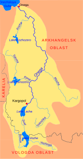
Catchment area of the Onega |
||
| Data | ||
| Water code | RU : 03010000112103000000017 | |
| location | Arkhangelsk Oblast ( Russia ) | |
| River system | Onega | |
| source |
Lacha lake near Kargopol 61 ° 27 ′ 24 ″ N , 38 ° 53 ′ 38 ″ E |
|
| Source height | 118 m | |
| muzzle | at Onega in the White Sea Coordinates: 63 ° 55 '46 " N , 37 ° 59' 4" E 63 ° 55 '46 " N , 37 ° 59' 4" E |
|
| Mouth height | 0 m | |
| Height difference | 118 m | |
| Bottom slope | 0.28 ‰ | |
| length | 416 km | |
| Catchment area | 56,900 km² | |
| Discharge at the Nadporozhskiy Pogost A Eo gauge : 12,800 km² Location: 400 km above the mouth |
MQ 1885/1988 Mq 1885/1988 |
112 m³ / s 8.8 l / (s km²) |
| Discharge at the Tscherepowskaja A Eo gauge : 29,500 km² Location: 291 km above the mouth |
MQ 1941/1999 Mq 1941/1999 |
274 m³ / s 9.3 l / (s km²) |
| Discharge at the gauge Kazakowo A Eo : 40,600 km² Location: 229 km above the mouth |
MQ 1929/1999 Mq 1929/1999 |
367 m³ / s 9 l / (s km²) |
| Left tributaries | Kena , Iksa , Somba , Schomokscha , Bolschaja Kerneschka , Koscha | |
| Right tributaries | Voloschka , Moscha , Verkhnyaya Telsa , Nizhnyaya Telsa , Kodina , Mudjuga , Njulnjaja , Wonguda | |
| Flowing lakes | Lacha lake | |
| Medium-sized cities | Onega | |
| Small towns | Kargopol, Severooneschsk | |
| Ports | Onega | |
|
The Onega in Severooneschsk |
||
|
Satellite image of the Onega |
||
The 416 km long Onega ( Russian Оне́га ) is a river in the northwest of the European part of Russia . It forms the outflow of Latschasees and ends at the port city of Onega in the Onegabucht of the White Sea .
description
The Onega leaves Lake Lacha on its northeastern bank near Kargopol in the southwest of Arkhangelsk Oblast . From there it flows in a wide valley in a predominantly north and north-east direction through the sparsely populated taiga .
At Mirny , it passes the Plesetsk cosmodrome and then turns mainly in north-westerly directions. About 75 km from its mouth, the Onega divides into two arms of the river near Anziferowski Bor , the Great and the Small Onega ( Russian Большая or Малая Онега ). At Ust-Koscha the two arms unite again and form a river island with a diameter of around 20 km . A little later, the Onega reaches the Onega Bay of the White Sea, named after it, below the city of Onega.
Hydrology and use
The Onega shows a nivo-pluvial discharge course with a pronounced maximum discharge at the time of the snowmelt in May and June and a significantly smaller secondary maximum caused by rain in October. The annual minimum runoff falls in March. The Onega begins to freeze over between late October and early December. The ice breaks on average from mid-April to early May, followed by the annual spring flood .
During the ice and flood-free time, the Onega is navigable in sections, the most important port is Onega. In the area of its mouth, the tides of the White Sea are already affecting the Onega, it has a tidal range of 1.5 m.
Web links
- The Onega River on the tourist site skitalets.ru (russ.)
- UNESCO - Onega at Cherepovskaya
- UNESCO - Onega at Kazakovo
- UNESCO - Onega at Nadporozhskiy Pogost
Individual evidence
- ↑ a b c Onega ( page no longer available , search in web archives ) Info: The link was automatically marked as defective. Please check the link according to the instructions and then remove this notice. in the geographical name database of Yandex (russ.)
- ↑ a b c d e Article Onega in the Great Soviet Encyclopedia (BSE) , 3rd edition 1969–1978 (Russian)
- ↑ a b Onega in the State Water Register of the Russian Federation (Russian)
- ↑ Onega at the Nadporozhskiy Pogost gauge - hydrographic data from R-ArcticNET
- ↑ Onega at the Tscherepowskaja gauge - hydrographic data from R-ArcticNET
- ↑ Onega at the Kazakowo gauge - hydrographic data from R-ArcticNET
- ↑ UNESCO - Onega at Porog ( Memento of the original from March 24, 2012 in the Internet Archive ) Info: The archive link was inserted automatically and has not yet been checked. Please check the original and archive link according to the instructions and then remove this notice.


