Oswego (Illinois)
| Oswego | ||
|---|---|---|
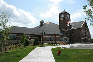
 Oswego City Hall |
||
| Location in Illinois | ||
|
|
||
| Basic data | ||
| Foundation : | 1833 | |
| State : | United States | |
| State : | Illinois | |
| County : | Kendall County | |
| Coordinates : | 41 ° 41 ′ N , 88 ° 21 ′ W | |
| Time zone : | Central ( UTC − 6 / −5 ) | |
|
Inhabitants : - Metropolitan Area : |
30,355 (status: 2010) 9,461,105 (status: 2010) |
|
| Population density : | 749.5 inhabitants per km 2 | |
| Area : | 40.5 km 2 (approx. 16 mi 2 ) | |
| Height : | 195 m | |
| Postal code : | 60543 | |
| Area code : | +1 630 | |
| FIPS : | 17-56887 | |
| GNIS ID : | 415202 | |
| Website : | www.oswegoil.org | |
| Mayor : | Brian LeClercq (President) | |
 Center of Oswego |
||
Oswego is a municipality (with the status " Village ") in Kendall County in the US -amerikanischen State Illinois . In 2010 Oswego had 30,355 inhabitants.
Oswego is part of the Chicago metropolitan area .
geography
Oswego is located in the southwestern suburbs of Chicago on both sides of the Fox River , a right tributary of the Illinois River, which flows into the Mississippi . The place extends over 40.5 square kilometers. Oswego is for the most part in the Oswego Township and to a lesser extent in the Bristol Township .
Neighboring places to Oswego are Aurora (10.1 km north along the Fox River), Montgomery and Boulder Hill (on the northern boundary), Bolingbrook (27.3 km east), Plainfield (15.1 km southeast) and Yorkville ( on the western outskirts).
Downtown Chicago is 69.5 km east-northeast and Rockford is 122 km north-west.
traffic
The Fox River has been expanded by numerous dams to a shipping route that has connection with the Great Lakes and the Mississippi.
The US Highway 30 forms the northeastern city limits. The US Highway 34 leads northeast-southwest direction as the main road through Oswego and crosses in the city center a bridge over the Fox River. Illinois State Routes 31 and 71 continue to meet in Oswego . All other roads are subordinate routes as well as inner-city connecting roads.
A railway line operated by the Illinois Railway , a small Omnitrax- owned railroad company, runs through northwest Oswego .
The nearest airport is Chicago's O'Hare International Airport, 39 miles northeast .
Demographic data
According to the 2010 census , there were 30,355 people in 9,935 households in Oswego. The population density was 749.5 inhabitants per square kilometer. Statistically, 3.05 people lived in the 9,935 households.
The racial the population was composed of 85.6 percent white, 5.2 percent African American, 0.2 percent Native American, 3.4 percent Asian and 3.2 percent from other ethnic groups; 2.2 percent were descended from two or more races. Hispanic or Latino of any race was 11.7 percent of the population regardless of ethnicity.
32.6 percent of the population were under 18 years old, 60.6 percent were between 18 and 64 and 6.8 percent were 65 years or older. 50.9 percent of the population was female.
The average annual income for a household was 93,588 USD . The per capita income was $ 33,606. 3.9 percent of the population lived below the poverty line.
Personalities
- Julianne Sitch (* 1983), soccer player
- Edward Wormley (1907–1995), furniture designer
Individual evidence
- ↑ a b American Fact Finder. Retrieved February 19, 2013
- ↑ Distance information according to Google Maps. Accessed on February 19, 2013
