Ott thing
|
Ott thing
municipality Mengkofen
Coordinates: 48 ° 41 ′ 8 ″ N , 12 ° 23 ′ 37 ″ E
|
|
|---|---|
| Height : | 431 m above sea level NN |
| Residents : | 54 (May 25 1987) |
| Incorporation : | May 1, 1978 |
| Postal code : | 84152 |
| Area code : | 08733 |
|
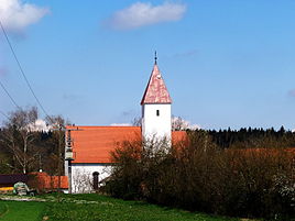
Side church St. Wolfgang Ottending
|
|
Ottending is a small village in the municipality of Mengkofen in the district of Dingolfing-Landau in the Free State of Bavaria in the Federal Republic of Germany . It belongs to the district of Mühlhausen , which was an independent municipality until April 30, 1978 .
geography
Ottending is at the intersection of the state road St2141 and the district road DGF 43 (Ottendinger Straße). The Ottendinger Graben rises in the village, through which, among other things, the Gießüblgraben flows into the Aiterach . The town center is at an altitude of 431 meters.
For the census of May 25, 1987, a population of 54 in 14 residential buildings with 16 apartments was recorded in the village of Ottending. The official statistics only provide more up-to-date figures from the population update from the municipality level .
history
According to Joseph von Hazzi's statistics on the Duchy of Baiern from 1808, the village of Ottending, with 13 houses and just as many hearths, belonged to the Rimbach council in the Lengthall office . When the community was formed in 1818 , however, it was added to the community of Mühlhausen . This was temporarily dissolved, Ottending came to the municipality of Rimbach. When it was finally dissolved on July 1, 1972, the community of Mühlhausen first came from the disbanded Mallersdorf district to the newly formed district of Dingolfing-Landau and was incorporated into Mengkofen on May 1, 1978 when the regional reform in Bavaria was completed.
church
In the center of the village there is a small Romanesque church from the second half of the 13th century, which is dedicated to St. Wolfgang . Two-storey south tower with a pyramid roof. The side altars were made around 1750 and are dedicated to St. Consecrated to Wolfgang and Josef. The altarpiece of the high altar from 1788 shows Mary as a refuge for sinners. During renovation work on the church, old, Gothic pointed arched windows and an entrance in the southeast were discovered. Old wall paintings were uncovered above the entrance to the sacristy. The special thing about the church is that you still have to operate the bells with a cable.
In ecclesiastical terms Otten thing belongs to the parish of St. Margaret ( Hofdorf ) and represents the southernmost part is geographically. By 2001 the side St. Wolfgang belonged to Expositur Dreifaltigkeitsberg the parish Hofdorf. The Dreifaltigkeitsberg branch was incorporated into the parish of Ottering (municipality of Moosthenning ) in 2001 , but without Ottending, which remained with the parish of Hofdorf.
Picture gallery
Listed farmhouses in Ottending:
See also
Individual evidence
- ^ Mengkofen community: Waters III development plan. Regulations: - Explanatory Report - Draft, May 9, 2006 (PDF file, 1.16 MB)
- ↑ Bayernviewer ( Memento of the original from April 8, 2015 in the Internet Archive ) Info: The archive link was automatically inserted and not yet checked. Please check the original and archive link according to the instructions and then remove this notice.
- ↑ Official directory for Bavaria, territorial status: May 25, 1987, Munich, 1991, page 173
- ↑ Joseph von Hazzi: Statistical information about the Duchy of Baiern, drawn from genuine sources. A general contribution to the country u. Human studies. Fourth volume. Nuremberg 1808, p. 233


