
Parik scale
| coat of arms | map |
|---|---|

|

|
| Basic data | |
| State : |
|
| Landscape : | South Karelia |
| Administrative community : | Imatra |
| Geographical location | 61 ° 33 ' N , 29 ° 30' E |
| Surface: | 760.72 km² |
| of which land area: | 592.94 km² |
| of which inland waterways: | 167.78 km² |
| Residents : | 4,842 (Dec. 31, 2018) |
| Population density : | 8.2 inhabitants / km² |
| Municipality number : | 580 |
| Language (s) : | Finnish |
| Website : | www.parikkala.fi |
Parikkala [ ˈpɑrikːɑlɑ ] is a municipality in eastern Finland with 4842 inhabitants (as of December 31, 2018). It is the northernmost municipality in the landscape of South Karelia . Parikkala borders Kitee to the north, Savonlinna to the west and Rautjärvi to the south . In the east lies the state border with Russia . Geographically and climatically, Parikkala belongs to the catchment area of Lake Ladoga, 35 km away in the Russian part of Karelia. The current community was created in early 2005 through the merger of the Parikkala, Saari and Uukuniemi communities .
The center of the municipality is the village of Kangaskylä with around 2000 inhabitants. Other villages are Kirjavala-Kesusmaa (500 inhabitants), Koitsanlahti (230 inhabitants), Kummunkylä, Melkoniemi (250 inhabitants), Mikkolanniemi (100 inhabitants), Saarenkylä (110 inhabitants), Savikumpu (200 inhabitants), Tarnala (200 inhabitants) and Kannas (200 inhabitants). Sights of Parikkala include the wooden churches of Parikkala (1817) and Uukuniemi (1797) and the brick church of Saari (1934). A chapel ( tsasouna ) and the archaeological excavations of an Orthodox village from the 15th-17th centuries remind of the Orthodox heritage of the area . Century in Papinniemi .
Parikkala has always been in the border area between west and east in the course of its history. In the Middle Ages, the Parikkala area belonged to Novgorod's sphere of influence and the inhabitants were Orthodox. The border between Sweden and Novgorod, established in the Treaty of Nöteborg in 1323 , ran nearby. In 1617 Parikkala came under Swedish rule in the Peace of Stolbowo . The new rulers founded a Lutheran congregation. In the period that followed, the Orthodox population was subjected to reprisals; some converted to the Lutheran faith, some emigrated to Tver and Olonez . In the Peace of Nystad , Parikkala returned to Russia in 1721. When all of Finland came under Russian rule in 1809, Parikkala was annexed to the newly founded Grand Duchy of Finland together with the rest of the Old Finland . In 1917 it became part of the independent Republic of Finland. When Finland had to cede East Karelia to the Soviet Union after the Second World War , around a third of the municipal area was separated by the new border.
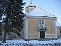
Parikkala Church
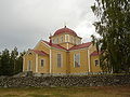
Uukuniemi Church


Sons and daughters
- Hannu Siitonen (* 1949), javelin thrower and European champion
- Sirpa Pietikäinen (* 1959), politician of the gathering party, minister
- Kirsi Boström (nee Tiira ; * 1968), orienteer and world champion
- Lisa Sounio-Ahtisaari (* 1970), politician of the collection party, entrepreneur, brand expert
Individual evidence
- ↑ Maanmittauslaitos (Finnish land surveying office): Suomen pinta-alat kunnittain January 1, 2010 . (PDF; 199 kB)
- ↑ Statistical Office Finland: Table 11ra - Key figures on population by region, 1990-2018
Web links
Imatra | Lappeenranta | Lemi | Luumäki | Parik scale | Rautjärvi | Ruokolahti | Savitaipale | Taipal Saari