Perlas (Faithful)
|
Perlas
City of Faithful
Coordinates: 50 ° 33 ′ 11 ″ N , 12 ° 19 ′ 1 ″ E
|
||
|---|---|---|
| Height : | 469 m | |
| Area : | 75 ha | |
| Residents : | 60 | |
| Population density : | 80 inhabitants / km² | |
| Incorporation : | July 1, 1950 | |
| Postal code : | 08233 | |
| Area code : | 037468 | |
|
Location of Perlas in Saxony |
||
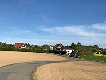
Perlas is a district of the city of Treuen in the Vogtlandkreis (Free State of Saxony ). The independent municipality with the districts Perlas book , Mahnbrück and Veit houses was on 13 July 1931 in Veit Housing renamed and incorporated on July 1, 1950 after spreading.
geography
location
Perlas is located northeast of Treuen in the east of the Vogtland natural area in the Saxon part of the historic Vogtland . The Lammelsbach rises in the village and drains into the White Elster via the Trieb . The highest point is the Wilhelmshöhe at 495.4 m above sea level. There is a 20 m high observation tower there.
Neighboring places
| Wolf puddle | ||
| Hartmannsgrün |

|
Calibration |
| Faithful | Veitenhäuser | book |
traffic
The Perlas corridor is touched by the Herlasgrün – Falkenstein railway operated by the Vogtlandbahn . South of Perlas joins the 298 national road in the state road 299 a.
history
The scattered settlement of Perlas was first mentioned in 1413 under the name Berlis . The scattered settlements Mahnbrück and Veitenhäuser were built in the southern corridor in 1576 and 1791, respectively. In the eastern corridor, the Buch settlement emerged from a single estate after 1814. The manorial rule over Perlas lay with the Treuen manor until the 19th century .
Perlas belonged to the Electoral Saxon or Royal Saxon Office of Plauen until 1856 . In 1856 the place was affiliated with the Treuen court office and in 1875 with the Auerbach administration . The Herlasgrün – Oelsnitz railway has been running through the town hall without stopping since 1865 .
The municipality of Perlas was renamed Veitenhäuser on July 13, 1931 and incorporated into Treuen on July 1, 1950. As a result of the second district reform in the GDR , Perlas came as a district of the city of Treuen in 1952 to the district of Auerbach in the Chemnitz district (renamed the Karl-Marx-Stadt district in 1953 ), which was continued as the Saxon "Auerbach district" from 1990 and in 1996 in the Vogtland district rose.
Attractions
The Perlaser Tower on Wilhelmshöhe is a striking vantage point near Treuen. From this 20-meter-high tower, built in 1907, you can see over Treuen and, earlier, also over large parts of the Vogtland . Next to the tower is a station point of the Royal Saxon Triangulation from 1876.
Web links
- Perlas in the Digital Historical Directory of Saxony
- Perlas on the website of the city of Treuen
- Perlas in the Vogtlandkreis geoportal
Individual evidence
- ^ Perlas in the Digital Historical Directory of Saxony
- ^ Perlas on the website of the city of Treuen
- ↑ The Treuen manor in the lower part on www.sachsens-schlösser.de
- ^ The upper part of the Treuen manor at www.sachsens-schlösser.de
- ^ Karlheinz Blaschke , Uwe Ulrich Jäschke : Kursächsischer Ämteratlas. Leipzig 2009, ISBN 978-3-937386-14-0 ; P. 76 f.
- ^ The Auerbach administration in the municipality register 1900
- ↑ Perlas on gov.genealogy.net


