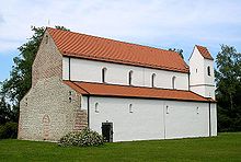
Petersberg (Erdweg)
Coordinates: 48 ° 20 ' N , 11 ° 18' E
Petersberg is a district of the Erdweg community in the Upper Bavarian district of Dachau .
geography
Petersberg is located approx. 12 km northwest of Dachau , approx. 15 km southeast of Aichach and approx. 6 km north of the A8 motorway (junction Odelzhausen and Sulzemoos ) on the St 2047 . The church village is located in the Glonn valley on the Zeitlbach .
history
In Petersberg, the Roman road Augsburg - Petersberg forked with the Straßbach ( Markt Indersdorf ) branch to Freising and via Rumeltshausen - Dachau to Oberföhring .
Around the year 1000 the Wittelsbachers built Glaneck Castle (Wittelsbach County Glaneck) on the mountain . This was given up after the Count's move to Scheyern , donated to the church and converted into the Petersberg Monastery from 1104, which existed until 1119 when the monks moved into the newly founded Scheyern Monastery .
Today the castle site with the still clearly recognizable neck ditch in the west is designated as a ground monument . The basilica of St. Peter and Paul is located on the south side of the former castle .
Attractions
- Basilica of St. Peter and Paul : former Benedictine monastery church, three-aisled, Romanesque pillar basilica without transept, built between 1104 and 1119.
- Castle stable of the former Glaneck Castle .
- Pedestrian bridge for the way to the Petersberg: stamped concrete construction , around 1910, over the local railway line Dachau - Altomünster at km 23.348.
- Catholic rural adult education center Petersberg.
literature
- Heimatgeschichte Eisenhofen eV (Hrsg.): EISENHOFEN - local history Eisenhofen, Hof, Petersberg. 2015.
Individual evidence
- ^ Basilica Peter and Paul on the Petersberg - (Hans Schertl)
- ↑ The Petersberg - learn to live to believe - (official website of the Landvolkshochschule)
Web links
- Petersberg in the location database of the Bayerische Landesbibliothek Online . Bavarian State Library
- Erdweg community


