
Holy Trinity (Rentweinsdorf)
.jpg)

The Evangelical Parish Church of the Holy Trinity (Dreieinigkeitskirche), together with the castle opposite, forms a historical ensemble in the center of the Rentweinsdorf market ( Haßberge district , Lower Franconia ). The simple sacred building contains some important tombs of the former village lords, the barons of Rotenhan .
history
A castle chapel in Rentweinsdorf was mentioned as a branch of the Ebern parish church as early as 1317 . In the course of the introduction of the evangelical creed, the chapel was raised to an independent parish in 1533.
The lord of the castle Wolfgang Christoph von Rotenhan commissioned the construction of the parish church in 1597 . On January 19, 1601, the new church was consecrated. In 1612 the older tombs and epitaphs were transferred from the moated castle to the church.
In 1738 the windows were changed into baroque shapes. In 1743 a new facility was built. The slate-covered lantern hood of the tower dates from 1795.
description
Exterior construction
The stately, south-facing church is located to the west of the castle on the edge of the spacious plan area. On the outside, the buttresses of the retracted choir , the pointed arch portal of the tower and the tracery of the sound openings under the slate hood refer to the development in the post-Gothic period . The nave is structured by rusticated corner pilasters and two-storey curved gable panels. A low base zone runs around the entire church. The nave windows are arranged on two floors because of the inner gallery. In addition to the northern tower portal, two nave portals allow admission.
inner space
Simple wooden galleries surround the flat-roofed nave with four window axes. A post-Gothic reticulated vault spans the choir, the ribs grow out of the walls without mediation. The simple high altar and the rococo pulpit made of stucco marble were built around 1743. The richly carved organ case (around 1730) above the altar comes from the Bamberg Carmelite Church.
Tombs and epitaphs
The three brothers tomb
To the right of the choir entrance is the epitaph for the three brothers Sebastian, Hans and Martin von Rotenhan. The three armored knights stand on their helmets between two Renaissance columns. At the top, a triple pass frames the triple Rotenhan coat of arms. The family's heraldic animal, the red rooster, is on the crowning spangenhelm. The tomb, mostly attributed to Christoph Schneebach, is one of the most important such monuments in Franconia .
The left armed man is the humanist Sebastian von Rotenhan , who is considered to be the creator of the first map of Franconia. The inscription on the base plate reads:
“ Ano 1532 died Herr Sebastian / Ritter avch der Rechtten Doctor vnd / Dan Anno * 59 * Hans vnd im * 60 / Mertten all from Rottenhan (zv) Rentweinnstorff gebrv (de) ren their / Selen der Almechtige Gott merciful and * merciful Be amen "
The brothers were the sons of Matthes von Rotenhan and Walburga, a née Förtsch .
Sebastian and Anna Rufina von Rotenhan
In addition, the monumental epitaph of Sebastian von Rotenhan announces his early death. The nobleman died in 1588 at the age of only 30. He and his wife Anna Rufina kneel in front of the crucifix. Anna Rufina, born Riedesel von Eisenbach, is shown in elegant period costume, the man's armor indicates the knightly origin of the family.
The epitaph was created around 1590 in Georg Dümpel's Altenstein workshop. The master provided the work with his maker's mark and also left a self-portrait. The inscription "SBE" below is interpreted as a motto. In older literature, the script was interpreted as Simon Sculptor (in) Ebern . The high, altar-like structure shows reliefs of the resurrection and above the marriage coat of arms Rotenhan- Riedesel . The crowning piece is the depiction of God the Father with the globe, above which a pelican with his young can be seen.
When she married the twenty-three year old Sebastian in 1581, Anna Rufina was only 15 years old. During their seven-year marriage, she gave birth to her husband - sometimes referred to at the time as the "crown of nobility of valor" - five children, three of whom survived. In 1594 the widowed noblewoman married the former Bamberg canon Hans Veit von Würtzburg . She too died relatively young at the age of thirty-four (February 29, 1600).
The inscriptions on the base plates are in fracture . On the left panel you can find the words:
" In Jar Christi * 1588 freitas because * / 26 Aprilis Jst in gott different / Der Edell Vnd Ehrntuest Sebastian / vom Rottenhan zue Renttweins- / village * his age * 30 * Jar Vnd 11 * day: / whose souls God grace Amen "
The right counterpart bears the inscription:
“ In the Jar Christi * 1600 Jst in Gott / different from the Haus Rosenberg / ob Cronach die Edle vnd Ehrntvgenthaffte / Mrs. Anna Rvfina von Wirtzbvrg / born Ridteslin von Eisenbach of age (..) year. "
The monumental epitaph was originally intended for the Catholic parish church in Ebern. The Würzburg prince-bishop Julius Echter forbade the erection of the monument in the parish church because of the evangelical confession of those depicted. The stone was therefore brought to Rentweinsdorf in 1593.
Other grave monuments
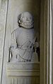
Two bronze casts commemorate Wolfgang Christoph († 1605) and Hans Georg († 1613) von Rotenhan. The two stylistically matching panels come from the Nuremberg workshop of Jakob Weinmann, whose signature can be found on the monument from 1613.
On the walls of the church there are numerous other grave monuments of family members, in addition to a few smaller bronze plates, several sandstone tablets , coats of arms and inscriptions.
- gallery

Hans Georg von Rotenhan

Sebastian, Hans and Martin von Rotenhan

Sebastian and Anna Rufina von Rotenhan ...
... and the sculptor's self-portrait

The high tower of the epitaph

Heraldic stones under the gallery


literature
- Georg Dehio : Handbook of the German art monuments. Bavaria I: Franconia. Munich, Berlin, 2nd edition 1999, ISBN 3-422-03051-4 .
- Isolde Maierhöfer: The inscriptions of the district of Haßberge. (The German inscriptions, 17th volume). Munich 1979.
- The art monuments of the Kingdom of Bavaria III, 15, District Office Ebern. Munich 1916.
Coordinates: 50 ° 3 ′ 47.7 ″ N , 10 ° 47 ′ 59.5 ″ E