Piz Grialetsch
| Piz Grialetsch | ||
|---|---|---|
|
Piz Grialetsch and Fuorcla Vallorgia from the west, taken by a helicopter. |
||
| height | 3130 m above sea level M. | |
| location |
|
|
| Mountains | Albula Alps | |
| Dominance | 0.841 km → Piz Vadret | |
| Notch height | 164 m ↓ Fuorcla Vallorgia | |
| Coordinates | 792 438 / 174473 | |
|
|
||
| Normal way | Through the southern flank | |
|
Piz Grialetsch (left) and Scalettahorn (center). Image taken by Gadmen in Dischma . |
||
|
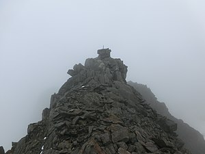
Steinmann on the Piz Grialetsch in the fog |
||
The Piz Grialetsch ( Rhaeto-Romanic from gregaricium "Schafalp", derivation from the Latin grex "herd") is a mountain between Davos and the Engadin in the canton of Graubünden in Switzerland at an altitude of 3,130 m above sea level. M. Because of its extensive view, it is a mountain that is often climbed, both in winter and in summer.
Location and surroundings
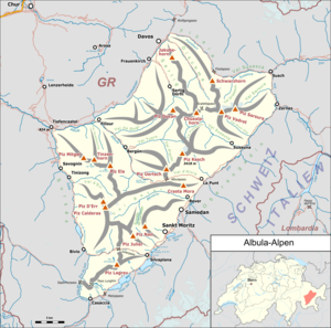
The Piz Grialetsch belongs to the Grialetsch area, a subgroup of the Albula Alps . The municipal boundaries between Davos , S-chanf and Zernez meet at the summit . The Piz Grialetsch is bordered in the northwest by the Dischma valley , in the south by the Vallorgia and in the east by the Val Grialetsch.
The neighboring peaks include the Chilbiritzenspitz in the north, the Piz Vadret in the southeast and the Scalettahorn in the west.
The Piz Grialetsch is surrounded on all sides by glaciers. The Scaletta Glacier is on the north flank, the Vadret da Grialetsch in the east and the Vadret Vallorgia in the south-west.
Frequent starting points are the Flüelapass , Dürrboden in the Dischma valley , Susauna in the Engadine and the two SAC huts Chamanna da Grialetsch and Chamanna digl Kesch .
Routes to the summit
Summer routes
Through the southern flank
- Starting point: Flüelapassstrasse ( 2263 m ), Chamanna da Grialetsch ( 2542 m ), Susauna ( 1682 m ), Chamanna digl Kesch ( 2625 m ) or Dürrboden ( 2007 m )
- Via: Fuorcla Vallorgia ( 2969 m )
- From the Flüelapassstrasse through the Val Grialetsch to Chamanna Grialetsch, then over the Vadret da Grialetsch to Fuorcla Vallorgia
- From Susauna through the Val Susauna, then through the Vallorgia and finally over the Vadret Vallorgia to Fuorcla Vallorgia
- From the Chamanna digl Kesch through the Val dal Tschüvel, then the Val Funtauna and the Vallorgia, at the end over the Vadret Vallorgia to the Fuorcla Vallorgia
- From Dürrboden via Fuorcla da Grialetsch to Chamanna Grialetsch, then via Vadret da Grialetsch to Fuorcla Vallorgia
- From Dürrboden over the Scalettapass, south of the Scalettahorn, then over the Vadret Vallorgia to Fuorcla Vallorgia
- Difficulty: L
- Time required: ½ hour from Fuorcla Vallorgia
- 4¼ hours from the Flüelapassstrasse, 2 hours from the Chamanna da Grialetsch
- 5 hours from Susauna
- 4¼ hours from Chamanna digl Kesch
- 3½ hours from Dürrboden via Chamanna Grialetsch
- 4½ hours from Dürrboden via the Scalettapass
- Note: All routes lead over a glacier and require appropriate equipment
Over the west ridge
- Starting point: Scalettahorn ( 3086 m )
- Difficulty: WS
- Time required: ¾ hours
Through the north flank to the west ridge
- Starting point: Dürrboden ( 2007 m )
- Via: Gletschtälli, Scalettagletscher, Westkamm
- Difficulty: WS
- Time required: 3¾ hours
Through the northwest flank
- Starting point: Dürrboden ( 2007 m )
- Via: Gletschtälli, Scalettagletscher, northwest flank
- Difficulty: WS
- Time required: 3½ hours
Over the north ridge
- Starting point: Flüelapassstrasse ( 2263 m ), Dürrboden ( 2007 m ), Chamanna da Grialetsch ( 2542 m ) or Chilbiritzenspitz ( 2853 m )
- Via: Ridge depression south of the Chilbiritzenspitz, rock ridge. Particularly brittle bumps are avoided on the glacier plateau on the west side.
- Difficulty: ZS-
- Time required: 7¾ hours from the Flüelapassstrasse, 5 hours from Dürrboden, 3½ hours from the Chamanna da Grialetsch or 2 hours from the Chilbiritzenspitz
- Comment: Brittle rock, route no longer advisable
Winter routes
From the Chamanna da Grialetsch
- Starting point: Chamanna da Grialetsch ( 2542 m ), Teufi (Davos) ( 1700 m ), Flüelapassstrasse ( 2300 m ) or Röven ( Susch ) ( 1848 m )
- Via: From Chamanna da Grialetsch via Vadret da Grialetsch, Fuorcla Vallorgia to the saddle east of P. 3045. From there on foot over the west ridge to the summit.
- Exposures: NE, S
- Difficulty: WS +
- Time required: 2½ hours from Chamanna da Grialetsch, 6½ hours from Teufi, 4½ hours from the Flüelapassstrasse, 5½ hours from Röven
- Note: The Flüela Pass is closed in winter. Therefore, the Flüelapassstrasse and Röven are not always accessible in winter.
From the Chamanna digl Kesch
- Starting point: Chamanna digl Kesch ( 2625 m )
- Via: Val Tschüvel, Val Funtauna, Vallorgia, Vadret Vallorgia to the saddle east of P. 3045. From there on foot over the west ridge to the summit.
- Exposures: SW, S
- Difficulty: WS +
- Time required: 4 hours
Descent over the northern flank to Dischma
- Destination: Teufi (Davos) ( 1700 m )
- Via: From the saddle east of P. 3045 to the Scalettagletscher, Gletschtälli, Dürrboden
- Exposures: N, NW
- Difficulty: ZS +
- Alternative: Straight from the summit very steeply to the north S-
- Comment: Demanding descent. The Scaletta Glacier is very steep (on average 30 °, the upper part 40 °)
literature
- Manfred Hunziker: Club Guide, Bündner Alpen, Volume VI (From Septimer to Flüela). 3. Edition. Verlag des SAC, 2000, ISBN 3-85902-187-7 , pp. 429-434.
- Vital Eggenberger: Ski tours Graubünden South. Verlag des SAC, 2010, ISBN 978-3-85902-301-7 , pp. 213-214.
- National map of Switzerland, sheet 1217 Scalettapass, 1: 25000, Federal Office of Topography, 2011 edition.
Web links
Individual evidence
- ↑ a b SwissTopo (maps of Switzerland)
- ↑ Andrea Schorta: How the mountain got its name . Small Rhaetian name book with two and a half thousand geographical names of Graubünden. Terra Grischuna Verlag, Chur and Bottmingen / Basel 1988, ISBN 3-7298-1047-2 , p. 93 .


