Piz Güglia
| Piz Güglia
Piz Julier
|
||
|---|---|---|
|
Piz Julier seen from the east (St. Moritz) |
||
| height | 3380.4 m above sea level M. | |
| location | Canton of Graubünden , Switzerland | |
| Mountains | Albula Alps | |
| Dominance | 7 km → Piz Calderas | |
| Notch height | 489 m ↓ Fuorcla Güglia | |
| Coordinates | 778 199 / 151480 | |
|
|
||
| rock | granite | |
| Normal way | From Fuorcla Albana over the east ridge | |
|
Piz Güglia, taken from Piz Neir |
||
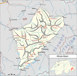
The Piz Güglia ( , Rhaeto-Romanic in the idiom Puter , in the idiom Surmiran Piz Gelgia , German Piz Julier ) is a mountain northeast of the Julier Pass in the canton of Graubünden in Switzerland with a height of 3380.4 m above sea level. M. It is one of the highest peaks in the Albula Alps , but is slightly overlooked by Piz Calderas and Piz Kesch . The extremely bulky figure that rises above Silvaplana falls down into the valley on all sides in mighty, sometimes steep granite walls and offers an imposing sight from all sides. On the northeast side it bears a small glacier, the Vadret Güglia . Thanks to its isolated location, it offers a wide view of the Upper Engadine .
Location and surroundings
The Piz Güglia is the namesake of the Güglia group , a subgroup of the Albula Alps. The municipal boundary between Silvaplana and St. Moritz runs over the summit . The neighboring peaks include the Piz Suvretta , Piz Bever , Piz Nair , Piz Albana , Piz Polaschin , Piz Valletta , Piz Surgonda and Corn Suvretta . Valley locations are Silvaplana, Champfèr and St. Moritz. A frequent starting point is the Julier Pass.
Origin of name
The origin of the name Güglia , Gelgia is explained from the Gallic word julo for yoke , pass .
Routes to the summit
The first ascent took place on July 12, 1859 by Gian Saratz and Jann Rüedi.
Via the east ridge (normal route)
- Starting point: St. Moritz-Suvretta ( 1894 m ) or Cna dal Stradin (Julier Pass) ( 2161 m )
- Route: Via Fuorcla Albana
- Marked as an Alpine Route in white-blue-white
- Difficulty: WS
- Time required: 5 hours from St. Moritz-Suvretta, 4 hours from Cna dal Stradin
Over the south ridge (Crasta d'Mez)
Nice, not difficult climbing
- Starting point: Cna dal Stradin (Julier Pass) ( 2161 m )
- Difficulty: ZS
- Time required: 4½ hours
Through the chimney on the south wall
Not recommended because of the loose rock
- Starting point: Cna dal Stradin (Julier Pass) ( 2161 m )
- Difficulty: ZS
- Time required: 3½ hours
Over the southwest ridge (Crasta Muntaratsch)
Longest ridge of the Piz Güglia
- Starting point: Cna dal Stradin (Julier Pass) ( 2161 m )
- Difficulty: ZS
- Time required: 4 hours
Through the west wall
- Starting point: Alp Güglia (Julier Pass) ( 2215 m )
- Difficulty: ZS
- Time required: 4 hours
Via the west wall rib (Crasta Lischander)
- Starting point: Alp Güglia (Julier Pass) ( 2215 m )
- Difficulty: ZS
- Time required: 4-4½ hours
Over the north ridge
Partly overhanging ridge steps
- Starting point: Fuorcla Güglia ( 2891 m )
- Difficulty: S +
- Time required: 4 hours
Through the north wall to the east ridge
- Starting point: Suvretta ( 1894 m )
- Difficulty: ZS +
- Time required: 6 hours
gallery
literature
- Eugen Wenzel, Paul Gross: club guide, Bündner Alps. Volume VI (Albula). 2nd Edition. Verlag des SAC, 1980, ISBN 3-85902-012-9 , pp. 45-52.
Web links
- Virtual panorama from Piz Güglia
- Tour report. hikr.org
- Tour report. summitpost.org
Individual evidence
- ↑ Andrea Schorta: How the mountain got its name . Small Rhaetian name book with two and a half thousand geographical names of Graubünden. Terra Grischuna Verlag, Chur and Bottmingen / Basel 1988, ISBN 3-7298-1047-2 , p. 91 .
- ↑ M [ichael] Caviezel: The Engadine in words and pictures. , Tanner, Samedan 1896 p. 234.


